That 12z Euro run was pretty amazing, with a major severe event starting Wednesday in the eastern Plains/MO/AR/LA and running through the night to GA and Carolinas on Thursdays. If the trough broadened just a bit, it would be even more impressive. The 18z GFS was also pretty dangerous looking for both days.
There is a pretty stout signal here across guidance for a possible widespread, multi day event. A large warm sector looks like it will be in place by Wednesday after at least two days of return flow following Sat-Sun's system. Evolution of the trough/timing is definitely a bit still up in the air, but a strong trough, assuming it isn't too linearly forced, interacting with a both a zonally and meridionally extensive warm sector like that could really yield something big. Still plenty of time for changes to either make it more or less volatile, but the ensemble guidance is pretty locked in and also the CIPS extended analogs have one of the strongest signals I've seen this far out for severe wx over quite a large chunk of real estate.
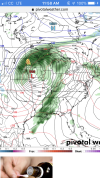
The 18z GFS had an absolutely incredible EML the morning of Wednesday. You're talking widespread very favorable thermodynamic profiles with something like this...

There is a pretty stout signal here across guidance for a possible widespread, multi day event. A large warm sector looks like it will be in place by Wednesday after at least two days of return flow following Sat-Sun's system. Evolution of the trough/timing is definitely a bit still up in the air, but a strong trough, assuming it isn't too linearly forced, interacting with a both a zonally and meridionally extensive warm sector like that could really yield something big. Still plenty of time for changes to either make it more or less volatile, but the ensemble guidance is pretty locked in and also the CIPS extended analogs have one of the strongest signals I've seen this far out for severe wx over quite a large chunk of real estate.
The 18z GFS had an absolutely incredible EML the morning of Wednesday. You're talking widespread very favorable thermodynamic profiles with something like this...
Last edited: