• Welcome to TalkWeather!
    We see you lurking around TalkWeather! Take the extra step and join us today to view attachments, see less ads and maybe even join the discussion.
    CLICK TO JOIN TALKWEATHER

Severe WX Wednesday/Thursday/Friday April 17th-19th Severe Threat

AL_ham_op

Member
Messages
135
Reaction score
44
Location
Clay, AL
And the bad thing about that is one of these days, they are going to write off the event and it is going to end up being one they should have been attentive to.
Absolutely.

I think another factor is that when people hear "outbreak" they immediately assume it will be nothing but EF-4s and EF-5s and often times it's not.
 

Kory

Member
Messages
4,928
Reaction score
2,119
Location
Tuscaloosa, Alabama
Absolutely.

I think another factor is that when people hear "outbreak" they immediately assume it will be nothing but EF-4s and EF-5s and often times it's not.
Yep, not everything will be 4/27. I’d say 20-30 tornadoes in one day with several strong is a solid outbreak (See Saturday/Sunday).
 

pritchlaw

Member
Messages
87
Reaction score
108
Location
Warrior, AL
It doesn't matter whether you call it an "outbreak." It is what it is. After the event especially, when we have actual numbers, there's no need to decide whether some event was an "outbreak."
 

Kory

Member
Messages
4,928
Reaction score
2,119
Location
Tuscaloosa, Alabama
One thing that makes me think thisnwont be a big event for N AL is the lack of a south wind right now.
This won’t be the case with a wide warm sector. This will be a narrow band of CAPE that works north just ahead of the QLCS. It may prove to be enough for a damaging wind/QLCS tornado threat.
 

RollTide18

Member
Messages
104
Reaction score
90
Location
Montgomery, AL
I was referring to the overall continual downplaying of last system which produced 2 EF-3s and 13 EF-2 with 63 and counting tornadoes. And several of those EF-2 falling just next door in Mississippi.

I think people get caught up in the ratings a bit and when the SPC or NWS mentions strong tornadoes people generally think EF4 or EF5 tornadoes and when systems don’t produce that then people tend to downplay. Even just an EF2 is a significant or strong tornado, and just last month during the March 3 outbreak, an EF1 did considerable damage in Eufaula, I just think we need to have a bit more respect for tornadoes that are not EF4 or EF5, sorry to go off topic.
 

Evan

Member
Messages
2,287
Reaction score
1,440
Location
McCalla, AL
This won’t be the case with a wide warm sector. This will be a narrow band of CAPE that works north just ahead of the QLCS. It may prove to be enough for a damaging wind/QLCS tornado threat.

It seems too narrow to me. I think dewpoints are a bit underdone, and that the models are showing way too much DP variability over rather small distances that don't really make geographic sense.

What I'm concerned about is instability being under forecasted, or at least, showing a narrower and shallower area of instability than will actually occur.

This is one of those events in which a small shift in instability, timing, positioning, etc could cause us to see anything from a lower end threat wind threat (and minimal tornado potential) to a much broader damaging wind event (and a heightened tornado risk including up to the possibility of a strong tornado).

I actually think that's possibly one of the reasons the SPC gambled a bit on the ENH. The level of uncertainty is quite significant, and risk of this system over-performing is quite real (same goes for under-performing). IMO, April events in the Southeast have a tendency to over-perform.
 

Kory

Member
Messages
4,928
Reaction score
2,119
Location
Tuscaloosa, Alabama
You also shouldn't take surface based instability values verbatim without checking other variables. For example, the GFS, as it always does, improperly decouples the boundary layer with a 40kt 925mb jet and 50-60kt 850mb jet between 21z and 03z. Just doesn't make sense. Thus, it is showing SBCAPE values for 68/66 instead of 71/66 (which make a difference in the grand scheme of things).
 
Last edited:

Evan

Member
Messages
2,287
Reaction score
1,440
Location
McCalla, AL
I think people get caught up in the ratings a bit and when the SPC or NWS mentions strong tornadoes people generally think EF4 or EF5 tornadoes and when systems don’t produce that then people tend to downplay. Even just an EF2 is a significant or strong tornado, and just last month during the March 3 outbreak, an EF1 did considerable damage in Eufaula, I just think we need to have a bit more respect for tornadoes that are not EF4 or EF5, sorry to go off topic.

Definitely agree in regards to lower-rated tornadoes. Sometimes there is a tendency to downplay the damage and consequences of anything less than an EF3. Also, especially with this type of system, there's been a recent tendency for the general public and others to underestimate the overall wind damage potential that a squall line/QLCS can do. Especially if you get the right amount of shear dialed-in at the right time.

There's a somewhat vocal minority of people who now think if we don't have discrete supercells and PDS TOR watches that the risk to life and property is minimal.
 

TornadoFan

Member
Messages
2,860
Reaction score
2,790
Location
Colorado
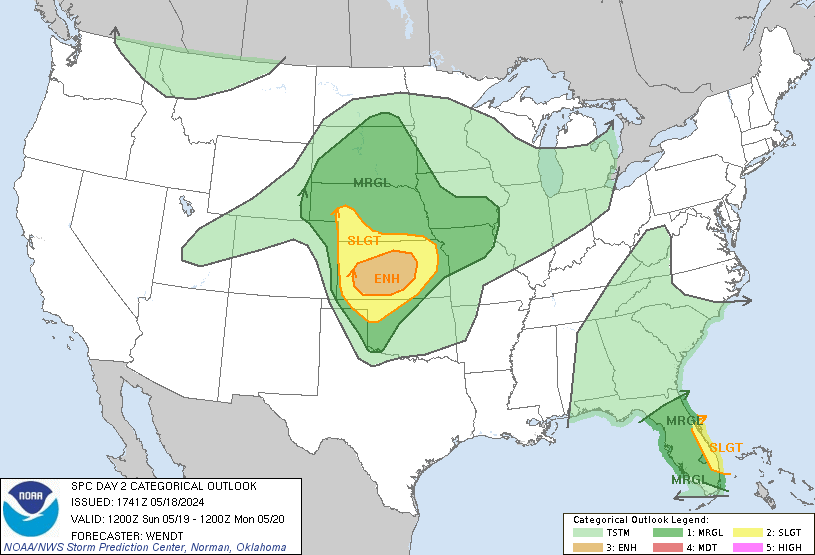
...THERE IS AN ENHANCED RISK OF SEVERE THUNDERSTORMS ACROSS MUCH OF
LOUISIANA...MISSISSIPPI...ALABAMA...AND THE FLORIDA PANHANDLE...

...SUMMARY...
Severe thunderstorms capable of tornadoes and extensive wind damage
are possible across parts of Louisiana, Mississippi and Alabama on
Thursday. Scattered severe storms are also possible as far east as
the Florida Panhandle, and as far north as western Tennessee.

...Synopsis...
An upper trough will amplify as it approaches the lower MS Valley
with mid to upper winds increasing to 60-80 kts. At the surface, a
cold front/outflow composite boundary will extend from eastern TX
into AR in the morning, and will shift east through the period.
Ahead of this early activity will be a deepening surface trough.
Preceding the front and early storms, southwesterly low-level winds
will create a surge of theta-e across LA, MS, and AL during the day,
with mean boundary layer dewpoints increasing to 68-70 F.

Very strong large-scale lift will develop over the lower MS Valley
during the day, with intense deep-layer differential divergence.
Cooling aloft will also accompany the cold front, further aiding
destabilization. The result will be widespread thunderstorms, with
corridors of damaging wind and tornadoes.

....LA...MS...AL...Western FL Panhandle...
Storms are expected to be ongoing Thursday morning along the cold
front/outflow, from southern AR into eastern TX. Some of these
storms could produce strong wind gusts or marginal hail.

Later in the day, a strong surge of deeper low-level moisture will
spread across LA and MS, coincident with 850 mb winds increasing to
over 50 kt. Both instability and shear will increase, and conditions
will become favorable for supercells and tornadoes. Forecast
soundings indicate effective SRH on the order of 300-400 m2/s2
across the entire area. Thus these midday storms may be severe with
a few tornadoes possible should they remain cellular.
 

South AL Wx

Member
Meteorologist
Messages
310
Reaction score
315
Location
Wetumpka, AL
Special Affiliations
  1. SKYWARN® Volunteer
The latest SPC outlook for tomorrow has expanded the Enhanced Risk a bit to the east, and also extended the hatched area. Also mentions the possibility of an upgrade to Moderate Risk:

day2otlk_1730.gif


day2probotlk_1730_any.gif


Early convection due to warm advection in the 15-18Z period lends
some uncertainty as to air mass quality for latter-day convection
with the front. If the rain is too widespread across LA and southern
MS, it could temper instability for the expected QLCS. On the other
hand, if the midday activity remains more cellular, several
tornadoes could occur. As such, will defer possible upgrade to
Moderate Risk to upcoming Day 1 updates.
 

Richardjacks

Member
Meteorologist
Messages
1,161
Reaction score
1,331
Location
Atop Red Mountain Birmingham, Al
You also shouldn't take surface based instability values verbatim without checking other variables. For example, the GFS, as it always does, improperly decouples the boundary layer with a 40kt 925mb jet and 50-60kt 850mb jet between 21z and 03z. Just doesn't make sense. Thus, it is showing SBCAPE values for 68/66 instead of 71/66 (which make a difference in the grand scheme of things).
Very true, that can make a significant difference. I am surprised to see the hatched area so far north and east but this will be a very dynamic storm with tons of energy. I wouldn't be surprised to see a derecho west of 65 Thu evening...it could be fairly far south and limit potential north of there.
 

Kory

Member
Messages
4,928
Reaction score
2,119
Location
Tuscaloosa, Alabama
Very true, that can make a significant difference. I am surprised to see the hatched area so far north and east but this will be a very dynamic storm with tons of energy. I wouldn't be surprised to see a derecho west of 65 Thu evening...it could be fairly far south and limit potential north of there.
Euro gets some solid 800-1,000 J/KG CAPE up toward the 20/59 corridor with a very cellular storm mode. Looking at shear vectors...they're WSW/SW...
 

AL_ham_op

Member
Messages
135
Reaction score
44
Location
Clay, AL
Very true, that can make a significant difference. I am surprised to see the hatched area so far north and east but this will be a very dynamic storm with tons of energy. I wouldn't be surprised to see a derecho west of 65 Thu evening...it could be fairly far south and limit potential north of there.
Hopefully that threat will remain west of 65. I've had more than my fair share of trees down this year. Not the same thing, but that 12/8/18 wind event was particularly rough on me.
 

Richardjacks

Member
Meteorologist
Messages
1,161
Reaction score
1,331
Location
Atop Red Mountain Birmingham, Al
One thing I am seeing is that the 2ndry low on the NAM is forming further south and moving northeast through Mississippi, this type of scenario will be more efficient at pumping higher thet e air further north as it gets wrapped into the low and moves with it...a bit different than a 2ndry low that forms over NE MS and then moves northeast. this kind of look makes me wonder if the local office will follow the SPC lead..in my eyes supports a enh risk, if it is correct
 
Logo 468x120
Back
Top