• Welcome to TalkWeather!
    We see you lurking around TalkWeather! Take the extra step and join us today to view attachments, see less ads and maybe even join the discussion.
    CLICK TO JOIN TALKWEATHER
  • April 2024 Weather Video of the Month
    Post your nominations now!

Svr Wx Threat Sun 2/26/2023 (KS, OK, TX, MO) & Mon 2/27/2023 (IL/IN/OH)

KevinH

Member
Messages
1,832
Reaction score
2,920
Location
West Central GA
Removed MS, AR from title

-I don’t remember adding them lol
-focusing on the areas with the HIGHEST risk
 
Last edited:

atrainguy

Member
Messages
882
Reaction score
1,263
Location
Linden, MI
Adam Lucio posted this on Facebook this morning. Enhanced is a bit slimmer, but basically same area. Trey from convective chronicles thinks that, based on past analogs, the main threat area could potentially shift west more into the TX panhandle by Sunday. Hopefully that's the case, seems like it's more rural out there, with Amarillo and some small towns being the exception.

Screen Shot 2023-02-24 at 10.40.53 AM.png
 

UncleJuJu98

Member
100,000th Post
Messages
3,940
Reaction score
5,119
Location
Birmingham
Post from the other thread for this thread on Monday. Sorry so many severe threats on the board I'm getting confused
What the heck is driving these analogs a more robust instability pool ahead of the high shear for Monday?

Wrong thread. This comment was intended for Monday lol
 

UncleJuJu98

Member
100,000th Post
Messages
3,940
Reaction score
5,119
Location
Birmingham
It maybe wise to sit down and look at this threqt more closely for the south, of course the plains threat will loom bigger and rightfully so than the souths but, still needs Watching
 

UncleJuJu98

Member
100,000th Post
Messages
3,940
Reaction score
5,119
Location
Birmingham
Definitely a prefrontal trough or some sort of kink in the line in a north south orientation from the surface low for Monday in Alabama, just checking with a quick glance at theta e. I could see around a 800-1200 sbcape range a high shear low cape event. Maybe from recent analogs it's picking up on the under forecasted instability for Alabama or portions of the south.
 

KevinH

Member
Messages
1,832
Reaction score
2,920
Location
West Central GA
ADDING INFO from former Feb 27 thread.

This forum will be busy the next few weeks.

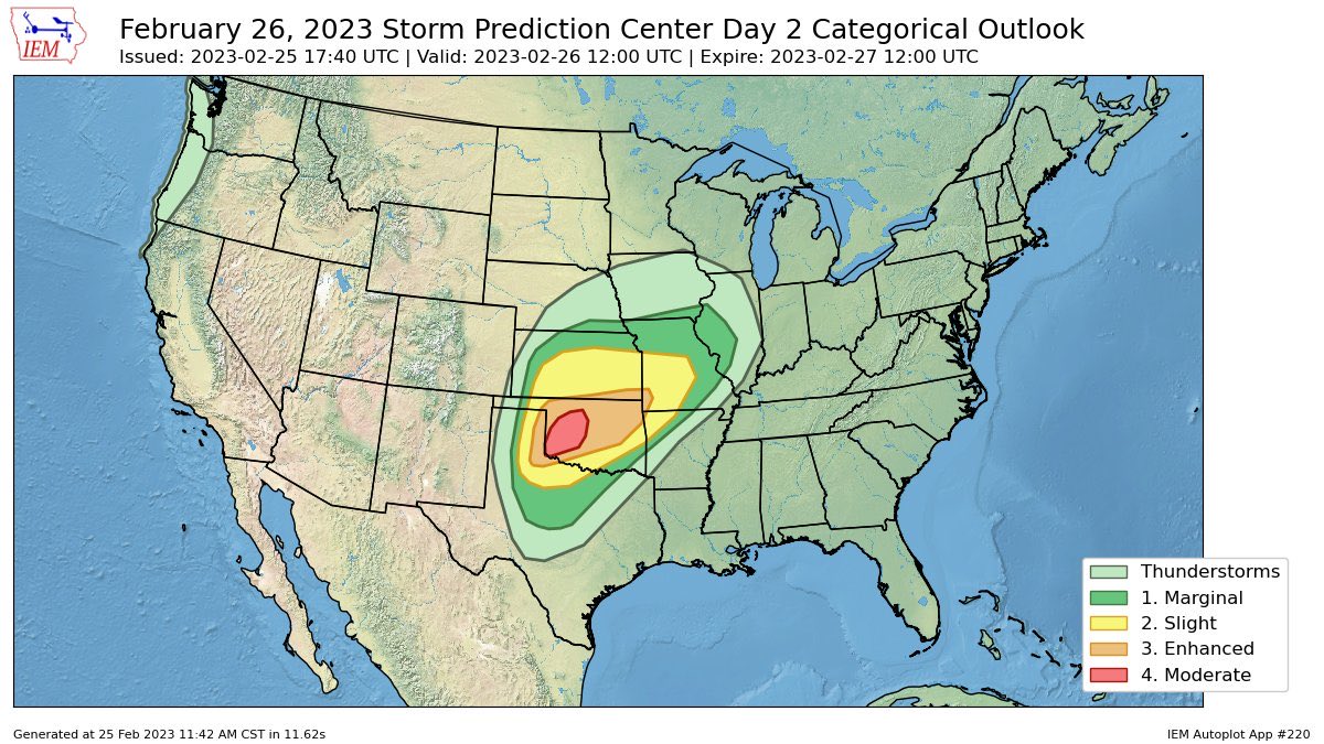
SPC now highlighting Monday, Feb 27. Per usual, I will adjust the title as needed based on what the SPC says).
1677263478555.png
ZCZC SPCSWOD48 ALL
ACUS48 KWNS 240954
SPC AC 240954

Day 4-8 Convective Outlook
NWS Storm Prediction Center Norman OK
0354 AM CST Fri Feb 24 2023

Valid 271200Z - 041200Z

...DISCUSSION...
...Monday/Day 4...
An upper-level trough and an associated 75 to 100 knot mid-level
jet, are forecast to move quickly east-northeastward into the Ohio
and Tennessee Valleys on Monday. Ahead of this feature, moisture
advection will likely increase surface dewpoints into the 50s F
across much of the region. Along the moist axis, weak instability
should develop. Any convection that can form ahead of the
upper-level trough will be supported by strong large-scale ascent
and lift associated with a 50 to 60 knot low-level jet. The
potential for convection is first expected to develop near the
Mississippi River around daybreak with convection moving quickly
eastward toward the Appalachians by midday. This convection is
forecast to remain low-topped and be embedded in a strong wind
field. For this reason, damaging wind gusts will be possible, mainly
due to downdrafts embedded in the strong surface pressure gradient.
A 15 percent area has been added to parts of eastern Kentucky and
eastern Tennessee, where the potential for severe winds appears to
be greatest.

...Tuesday/Day 5 to Friday/Day 8..
A cold front is forecast to move into the Gulf Coast states on
Tuesday, as a shortwave trough moves through the Rockies. Moisture
return on Tuesday is forecast to remain largely absent ahead of this
trough, suggesting the potential for severe thunderstorms will
remain low. On Wednesday, some moisture is forecast to advect
northward into the Gulf Coast states, where isolated to scattered
convection will be possible during the afternoon. However, model
solutions suggest that instability will remain weak, limiting the
severe weather potential. On Wednesday night into Thursday,
continued moisture advection should increase surface dewpoints up
into the 60s F from Georgia into the Carolinas. Although
thunderstorms will be possible near the axis of a low-level jet, the
weak instability that is currently forecast could be problematic.
From Thursday night into Friday, a shortwave trough is forecast to
move eastward from the southern Plains eastward across the Gulf
Coast states. Thunderstorms will be possible ahead of this feature
from the lower Mississippi Valley eastward to Florida. Although a
severe threat may develop across parts of the region, predictability
at this range remains low.
 
Last edited:

KevinH

Member
Messages
1,832
Reaction score
2,920
Location
West Central GA
Definitely a prefrontal trough or some sort of kink in the line in a north south orientation from the surface low for Monday in Alabama, just checking with a quick glance at theta e. I could see around a 800-1200 sbcape range a high shear low cape event. Maybe from recent analogs it's picking up on the under forecasted instability for Alabama or portions of the south.
I have moved Monday’s thread into this one. I dont know how to delete my own threads on here :(
 

UK_EF4

Member
Messages
573
Reaction score
1,327
Location
NW London
Fp1H0aDXsAELLOb
First moderate risk of the year apparently
 

ColdFront

Member
Messages
541
Reaction score
1,131
Location
Arctic
I think tomorrow will mainly be a wind/QLCS event, of course there could be a couple of embedded supercells before this completely forms into a line, I just don’t think it has that look.
 

KevinH

Member
Messages
1,832
Reaction score
2,920
Location
West Central GA
Posting this here in case people did not know and can go VOTE:


TornadoFan

Member
Messages
2,991
Reaction score
3,063
Location
Colorado
0600Z outlook. A 10% hatch for tornadoes has been added for Altus, OK and Vernon, TX.

...Synopsis...

A potent, negatively tilted midlevel trough will eject eastward into
the southern/central Plains late this afternoon and evening, and
become positioned over the Mid-MS Valley by Monday morning. Extreme
vertical shear will overspread the southern Plains vicinity ahead of
a deepening surface low and eastward-advancing cold front. Strong
forcing for ascent along the cold front and within a 100+ kt 500 mb
jet streak will aid in rapidly developing convection by late
afternoon across the eastern TX panhandle amid modest boundary-layer
moisture. Initially semi-discrete supercells will pose a risk for
tornadoes, a couple potentially strong (EF-2+ intensity) early in
the event across parts of western North TX into southwest OK.
Supercells are then expected to grow upscale into a fast-moving
linear convective system shifting east/northeast across much of OK
and southeast KS.

Linear convection and strong gusts are expected to continue
northeast overnight across MO and into western IL.

...TX/OK/KS...

Increasing southerly low-level flow will transport mid/upper 50s
dewpoints into far southern KS by 00z. Near-60 F dewpoints are
possible as far north as the I-40 corridor in OK by late afternoon.
While the main synoptic surface low is forecast to deepen and spread
east/northeast across the central Plains, several members of 00z
deterministic guidance suite suggest a meso-low may develop in
southwest OK, near the OK/TX border. A corridor of relatively
greater tornado potential will exist near this triple point feature
where a higher-quality warm sector will reside. Surface-based
instability will be maximized within this corridor, with SBCAPE
around 500-1000 J/kg forecast. A couple of strong tornadoes will be
possible within a corridor of enhanced low-level shear, very large,
favorably curved hodographs, and 0-1 km SRH values increasing to
near 500 m2/s2 as an 850 mb low-level jet strengthens to 65+ kt.

As initial convection spreads eastward across western OK, upscale
development into a fast moving line of storms is expected. Capping
will prevent open warm sector convection for the most part, with
strong forcing along the cold front overcoming the cap and being the
main forcing mechanism for convection. Intense mass flux along the
front, combined with extreme vertical shear is expected to be
sufficient for widespread severe and damaging gusts despite SBCAPE
values generally at or below 500 J/kg. Some threat for mesovortex
tornadoes will exist, but this threat may be mitigated by modest
low-level thermodynamics further east later in the evening.
 

UK_EF4

Member
Messages
573
Reaction score
1,327
Location
NW London
I think I've personally been underestimating the magnitude of today's severe threat.

Not only are we very likely to see a derecho, an outbreak of QLCS and embedded supercell tornadoes, including strong ones, does not seem out of the question to me.
 

UK_EF4

Member
Messages
573
Reaction score
1,327
Location
NW London
Latest HRRR continues to look pretty significant with a mix of QLCS and embedded supercells. I wouldn't be surprised to see the SPC put out a 15#% tornado risk next outlook.
 
Back
Top