• Welcome to TalkWeather!
    We see you lurking around TalkWeather! Take the extra step and join us today to view attachments, see less ads and maybe even join the discussion.
    CLICK TO JOIN TALKWEATHER
  • April 2024 Weather Video of the Month
    Post your nominations now!
Logo 468x120

Svr Wx Threat Sun 2/26/2023 (KS, OK, TX, MO) & Mon 2/27/2023 (IL/IN/OH)

TornadoFan

Member
Messages
3,191
Reaction score
3,436
Location
Colorado
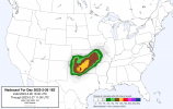
From the MD discussing the tornado watch:

Wind fields, which are already quite strong, are expected to further
strengthen as the system approaches. Current mesoanalysis estimates
the 0-6 km shear is already 70 kt, with forecast soundings
suggesting an increase to 85-90 kt is anticipated by 00Z. Forecast
hodographs also show robust low veering with height, supported by
50-60 kt flow around 1 km. Forecast soundings show surface to 500 m
storm-relative helicity is over 300 m2/s2 across the eastern TX and
OK Panhandles at 00Z.
 

UK_EF4

Member
Messages
573
Reaction score
1,329
Location
NW London
Any QLCS or embedded supercellular tornadoes are likely to be long tracked compared to usual QLCS tors, given just how fast the line is moving - in a similar sense to Dec 15th 2021. But I am now very concerned we could see an outbreak of strong-intense tornadoes across Oklahoma today given just how favourable the low level shear and the fact we still have 500-1000j/kg of CAPE in places coinciding with strong shear. Even without tornadoes, we are probably going to see a massive damaging wind threat. Could end up being pretty bad.
 

Austin Dawg

Member
Sustaining Member
Messages
900
Reaction score
1,394
Location
Leander, Texas
When's this event start, havent kept track, I'll probably tune in on my radarscope and see how things go
Looks like storms are firing northwest of Amarillo. I'm not sure if this is where it's going to begin, but there are a few severe warned cells in that area. If you're like me to give you a chance to get your RadarScope out and get it set up.
 

UncleJuJu98

Member
100,000th Post
Messages
4,078
Reaction score
5,351
Location
Birmingham
Seems like from what I've been reading these cells have a few hours of being semi discrete with a maximized tornado threat.. it'll be a interesting few hours.
 

UncleJuJu98

Member
100,000th Post
Messages
4,078
Reaction score
5,351
Location
Birmingham
Looks like storms are firing northwest of Amarillo. I'm not sure if this is where it's going to begin, but there are a few severe warned cells in that area. If you're like me to give you a chance to get your RadarScope out and get it set up.
Oh wow, it's about to kick off then that's the main initiator, seems a bit earlier than forecasted
 
Messages
2,905
Reaction score
4,811
Location
Madison, WI
It's interesting the CAMS have all been showing very strong capping where the obscene low-level shear is...HRRR also has the UH streaks displaced to the north of where the favorable parameters are. Hard to pull a good near-storm sounding that's not convectively contaminated.
 

UncleJuJu98

Member
100,000th Post
Messages
4,078
Reaction score
5,351
Location
Birmingham
It's interesting the CAMS have all been showing very strong capping where the obscene low-level shear is...HRRR also has the UH streaks displaced to the north of where the favorable parameters are. Hard to pull a good near-storm sounding that's not convectively contaminated.
Rap is your best bet for non contained close event soundings, or checking the SPC meso analysis to see what things look like.
 

SmokeEater

Member
Messages
463
Reaction score
680
Location
Folsom, NJ
Watch out, winds to 100 and a couple intense tornadoes likely.

* TORNADO WATCH FOR PORTIONS OF
FAR SOUTHWEST KANSAS
WESTERN OKLAHOMA
NORTHWEST TEXAS AND EASTERN PANHANDLE

* EFFECTIVE THIS SUNDAY AFTERNOON AND EVENING FROM 330 PM UNTIL
900 PM CST.

* PRIMARY THREATS INCLUDE...
A FEW TORNADOES LIKELY WITH A COUPLE INTENSE TORNADOES POSSIBLE
WIDESPREAD DAMAGING WINDS AND SCATTERED SIGNIFICANT GUSTS TO 100
MPH LIKELY
SCATTERED LARGE HAIL AND ISOLATED VERY LARGE HAIL EVENTS TO 2.5
INCHES IN DIAMETER POSSIBLE

SUMMARY...NUMEROUS SUPERCELLS ARE EXPECTED TO DEVELOP ACROSS THE
CENTRAL TO EASTERN TEXAS PANHANDLES AND SPREAD RAPIDLY
EAST-NORTHEAST ACROSS WESTERN OKLAHOMA AND FAR SOUTHWEST KANSAS, AS
THEY GROW UPSCALE INTO A FAST-MOVING SQUALL LINE.

Sent from my SM-S901U using Tapatalk
 

Tennie

Member
Messages
1,010
Reaction score
868
Location
Tennessee
Watch out, winds to 100 and a couple intense tornadoes likely.

* TORNADO WATCH FOR PORTIONS OF
FAR SOUTHWEST KANSAS
WESTERN OKLAHOMA
NORTHWEST TEXAS AND EASTERN PANHANDLE

* EFFECTIVE THIS SUNDAY AFTERNOON AND EVENING FROM 330 PM UNTIL
900 PM CST.

* PRIMARY THREATS INCLUDE...
A FEW TORNADOES LIKELY WITH A COUPLE INTENSE TORNADOES POSSIBLE
WIDESPREAD DAMAGING WINDS AND SCATTERED SIGNIFICANT GUSTS TO 100
MPH LIKELY
SCATTERED LARGE HAIL AND ISOLATED VERY LARGE HAIL EVENTS TO 2.5
INCHES IN DIAMETER POSSIBLE

SUMMARY...NUMEROUS SUPERCELLS ARE EXPECTED TO DEVELOP ACROSS THE
CENTRAL TO EASTERN TEXAS PANHANDLES AND SPREAD RAPIDLY
EAST-NORTHEAST ACROSS WESTERN OKLAHOMA AND FAR SOUTHWEST KANSAS, AS
THEY GROW UPSCALE INTO A FAST-MOVING SQUALL LINE.

Sent from my SM-S901U using Tapatalk

60/40 tornado probs on that watch.
 

UncleJuJu98

Member
100,000th Post
Messages
4,078
Reaction score
5,351
Location
Birmingham
About to start brewing me some java. We may see a show, potentially historic derecho, possibly up there with the great Midwest derecho in the early 2010s.
 
Top