TornadoFan
Member
Gonna need the cloud cover to really clear up to get any kind of instability. And the dew points are pretty low right now.
Follow along with the video below to see how to install our site as a web app on your home screen.
Note: This feature may not be available in some browsers.
Latest update:
...SUMMARY...
A derecho is forecast with widespread damaging winds and embedded
swaths of significant severe gusts from 80-110 mph, centered on
parts of Oklahoma this evening into tonight. Embedded tornadoes are
anticipated as well, with the greatest potential for strong
(EF2-EF3) tornadoes across southwest Oklahoma this evening.
...Southern Great Plains to the Mid-MS Valley...
Just-in-time moisture return from the western Gulf is still
anticipated ahead of a powerful shortwave trough ejecting from the
Southwest to the Lower MO Valley. 60+ F surface dew points remain
confined from the Piney Woods of east TX to the Concho Valley and
Edwards Plateau of west TX as of 16Z. Guidance continues to differ
with the northern extent of this richer moisture by evening in KS/OK
beneath a stout elevated mixed layer. Widespread cloudiness is also
evident over much of the southern Great Plains, although clearing
should occur from west to east across the High Plains. The net
result should be a narrow plume of surface-based instability along
the dryline from southwest KS to west TX between 21-00Z.
Scattered convection will break out after 21Z along the dryline and
become supercellular towards 00Z given very favorably enlarged low
to mid-level hodographs. Further moistening into the evening should
result in the most favorable potential for supercell tornadoes in
southwest OK between 00-03Z, in addition to very large hail.
Convection will likely grow quickly upscale into a solid QLCS,
accelerating east-northeast with embedded supercells and
mesovortices. Extreme low-level shear profiles in conjunction with
strengthening of 700-mb winds to around 90 kts behind the line
should result in widespread severe wind gusts. Embedded swaths of
80-110 mph winds both straightline and rotating are likely, with
stronger speeds into the EF2 range possible, until the QLCS outpaces
the richer moisture in the OK/KS/MO border area overnight. Scattered
damaging winds from strong to severe gusts may linger through the
early morning across MO towards the Mid-MS Valley, despite little to
no buoyancy, given the intense low-level wind fields.
The only one in February going back to 1877 was the one in 2008 on the 26th that affected Central Alabama. Outside of that, this would be the first one on record to affect Oklahoma.I can't really recall a February derecho.
@JPWX What is your source for “back to 1877”? I don’t think records are sufficiently dense to draw conclusions about relative frequency of derechos in February.The only one in February going back to 1877 was the one in 2008 on the 26th that affected Central Alabama. Outside of that, this would be the first one on record to affect Oklahoma.
There seems to be a stigma against wind driven high risks lately; certainly day one obs seeing where we are with surface instability before pulling the trigger is probably a good idea but with wording like that from the SPC you'd think a small 60% contour at 1630z or 2000z would verify.

@Taylor Campbell February 24th, 2000. 5 tornadoes, 12 wind reports, and 44 hail reports.


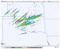
Looks like a cross between a "March of the Supercells" and a linear storm mode. Even after the primary storm mode shifts to a QLCS (if that indeed happens) I wouldn't be surprised if semi-discrete supercell structures within the line will remain capable of producing strong tornadoes.
HRRR has been trending more and more discrete for the past few hours. Surprised we haven't seen much attention to that

@MattPetrulli How high are the modelled LCLs over the southern, relatively discrete part of the line? HRRR sometimes, if not frequently, overestimates discrete mode in these highly-sheared, low-instability setups. If I recall correctly, weren’t there a number of times when this occurred in the fairly recent past? At this point I’m leaning toward a solid QLCS with very damaging winds rather than a semi-discrete or discrete mode. I think convection will grow upscale immediately rather than go through a brief semi-discrete stage.HRRR has been trending more and more discrete for the past few hours. Surprised we haven't seen much attention to that