• Welcome to TalkWeather!
    We see you lurking around TalkWeather! Take the extra step and join us today to view attachments, see less ads and maybe even join the discussion.
    CLICK TO JOIN TALKWEATHER

locomusic01

Member
Messages
1,350
Reaction score
3,758
Location
Pennsylvania
While I was researching New Richmond today, I came across a few reports of another tornado I haven't seen documented anywhere. Only problem is I can't pin down what day it actually happened because all of the reports mention either "yesterday" or "earlier this week" or whatever, but they're published on different days so there's no way to tell which specific day they're referencing. My guess would be either 6/11 (Salix F4) or 6/12 (New Richmond) but I don't know for sure yet.

Anywho, it struck north of Rock Rapids, up in the northwest corner of Iowa. Apparently it swept away at least two or three homes (granted, likely not well-built), threw a cow a quarter-mile to its death and - in the words of a few different reports - "scooped up earth in several places" in IA and just across the border in Rock County, MN. The funnel was also widely visible throughout the area, so there's no doubt it was a legit tornado.. whenever it happened.
 
Messages
1,004
Reaction score
766
Location
texas
found a video from salado that appears to show extensive debarking of low lying shrubbery.........yeah that thing was definitely stronger than an EF3
 
Messages
1,004
Reaction score
766
Location
texas
Greensburg was pretty similar to Joplin, large relatively slow moving wedges moving through populated areas and they both moved 20-25mph. However one thing noted in Joplin and has video evidence is that the most extreme damage occurred in just seconds by extremely intense subvortices, and survivor accounts from Greensburg tell the same story. While both tornadoes likely remained over a certain spot for 2-3 minutes the most extreme damage was done in seconds. Survivors in Greensburg describe the same thing as Joplin, the most intense part of the tornado lasted just a few moments. That being said Mayfield was undoubtedly an EF5 along with Tuscaloosa, but I just don’t see the damage or intensity matching quite up there with Greensburg.
Anywho, I also wish the quality was a lot better but that’s mainly why I used numerous aerial and ground photos to make sure it was as accurate as possible.
back home im guessing?
 
Messages
2,157
Reaction score
2,713
Location
Missouri
Dover would've been a big problem had it struck a more populated area. Even like a quarter-mile south would've been bad news, taking it straight through the middle of town.

nv8HjOF.jpg


FiL9bxc.jpg


PpIfvp6.jpg


gTbAh3G.jpg


B6zkaWP.jpg


60809629_10214025757894819_7038057307594293248_n.jpg


61584106_10214025757414807_4824565342309187584_n.jpg


kevin-harrison-home-destroyed-in-dover.jpg


kevin-harrison-son-collapsed-shelter.jpg
The shape and structure of the funnel is more or less identical to Bridge Creek-Moore, I have a feeling it would've been rated F5 had it tracked through the town directly.
 
Messages
1,004
Reaction score
766
Location
texas
1660469167101.png
theres new street view imagery showing the mayfield tornado along this highway. the one before the candle factory.
trees have already began to grow back leaves.
1660469225946.png
 
Messages
1,004
Reaction score
766
Location
texas
i'll just shut up forever i guess. cause apparently im not professional enough to chat on this site. i don't know how to find useful information or cool facts for this site that haven't already been posted before. so what am i supposed to do? have an account on this site that doesn't post anything??? apparently so.

like seriously. what the heck can i add to this whole thing that hasn't been brought up before? im pretty much useless here....
 
Last edited:

Sawmaster

Member
Messages
516
Reaction score
660
Location
Pickens SC
Special Affiliations
  1. SKYWARN® Volunteer
Well I know I'm not up to the level as most folks here, so I try to act accordingly. I only do replies and a few posts which may have something some others may not have seen or which may be of interest to them. Quietude has value.

Phil
 
Messages
1,004
Reaction score
766
Location
texas
Well I know I'm not up to the level as most folks here, so I try to act accordingly. I only do replies and a few posts which may have something some others may not have seen or which may be of interest to them. Quietude has value.

Phil
why do you always add phil...?
 

Sawmaster

Member
Messages
516
Reaction score
660
Location
Pickens SC
Special Affiliations
  1. SKYWARN® Volunteer
Call me old school, but it's proper etiquette to sign written messages. It also adds a personal touch which I like. Just how many of us old Southerners are :cool:

Phil
 

TH2002

Member
Sustaining Member
Messages
3,116
Reaction score
4,677
Location
California, United States
Special Affiliations
  1. SKYWARN® Volunteer
i'll just shut up forever i guess. cause apparently im not professional enough to chat on this site.
You have to remember that this is a forum, not Twitter. Low-effort five word posts don't cut it. Don't just SAY the damage from Holly Springs was bad for example. Actually tell us about and/or show us the specifics of what you found.

i don't know how to find useful information or cool facts for this site that haven't already been posted before. so what am i supposed to do? have an account on this site that doesn't post anything??? apparently so.

like seriously. what the heck can i add to this whole thing that hasn't been brought up before? im pretty much useless here....
It's really not that hard. One thing I like to do is use Tornado Archive and other similar sites. I pick a random year that peaks my interest, then pick a significant tornado and google the date (e.g. june 8 1995 tornado) and you can find a lot of information that way. Some tornadoes are obviously more loosely documented than others, but it's always worth it if you can uncover some damage photos and/or useful knowledge. This thread may be over 400 pages long but there's still A LOT of tornadoes that haven't been discussed here, or that haven't been discussed much.
 

TH2002

Member
Sustaining Member
Messages
3,116
Reaction score
4,677
Location
California, United States
Special Affiliations
  1. SKYWARN® Volunteer
Speaking of Holly Springs, I recently came across a collection of ground level photos from the Lamar Rd vicinity which may have not been posted before. The tornado was very likely at EF5 intensity in this area, though as previously mentioned, the NWS Memphis survey was... iffy, at best. Anyhow:
CXBW_heUkAAlR3E.jpg

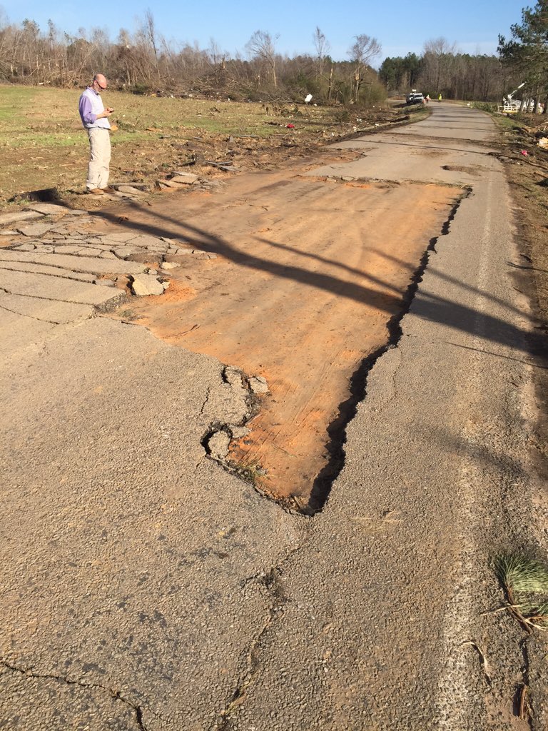
A large section of Lamar Rd itself was scoured away. Intense ground scouring is also evident in the background.


CRFLAA63GZEBBP5C5F7MSCRPQA.jpg

Well built homes away from the areas impacted by the most violent winds sustained roof and exterior wall loss. Poorly built homes were wiped out. Vehicles were thrown and mangled, and vast swaths of deforestation occurred. Note possible ground scouring in the bottom right photo, can't confirm this, although there was definite scouring elsewhere.

535304

Vehicle tossed and crushed.

The following photos are all of the same home, the only one in the area to be surveyed. It was a slab built, brick veneer frame home that was given a 165MPH EF3 rating, though I can't infer anything else about its construction. It is important to note that regardless of construction, this house didn't even sustain a direct hit, with the tornado's inner core passing between this house and another, though it was probably either on the edge of the violent damage core or hit by a subvortex.
535328

535306


Still the same home, but the vehicle damage gets much, MUCH worse:
535330

There's no way to pinpoint exactly where the vehicle originated, but it ended up here, in a completely mangled and unrecognizable heap. It may have originated from one of the destroyed homes on Cherry Brown Rd or Brown Apple Ln, roads that run perpendicular to Lamar Rd, with a possible distance range of 0.05 miles to a quarter mile. Approximately 2.25 miles to the southwest of this vicinity, another cluster of homes was destroyed on Hoover Rd, so it may have originated from as far as there, or any of the rural roads between the areas. Who knows?

Fig-16-ashland-google-earth-scouring-scaled.jpg

Between Cherry Brown Rd and Apple Ln, extreme ground scouring occurred, still plainly visible in this satellite view taken three months after the tornado.

holly-springs-diagram.jpg
The red line approximately marks the inner core of the tornado. Labels are as follows:

1. Home on the DAT, which the previous photos were of. The empty slab is from cleanup.
2. Home of unknown construction. The tornado's inner core just barely missed this home, though it likely still experienced winds of EF4+ intensity. It was destroyed (degree of damage unknown) and rebuilt after the tornado.
3. Was a mobile home before the tornado. Destroyed and replaced.
4. Home of unknown construction. Direct hit; it may have been a poorly constructed home, or a slab built home where the foundation was bulldozed during cleanup.

At least two mobile homes were eviscerated here; and multiple other homes sustained lesser degrees of damage. One of interest is a home out of frame at bottom left that probably sustained EF1 damage; it seems to have been abandoned after the tornado, as the 2021 satellite imagery showed it with the same degree of damage as in the March 2016 imagery.
 
Logo 468x120
Back
Top