• Welcome to TalkWeather!
    We see you lurking around TalkWeather! Take the extra step and join us today to view attachments, see less ads and maybe even join the discussion.
    CLICK TO JOIN TALKWEATHER
Messages
1,004
Reaction score
766
Location
texas
So far from almost hours of digging through the very depths of the internet I haven’t found any photos or videos from the 2008 Trousdale wedge, it occurred at night and was probably rainwrapped and huge like the Clark State Lake megawedge from the same family. Buttermilk would’ve been almost impossible to chase or photograph because it literally occurred in the middle of no where lol. While on the topic of the Buttermilk EF3, I’ve got to say I was really impressed by the damage it left behind, there was pretty clear ground scouring visible on aerial imagery even a month after the tornado. The tree and vehicle damage descriptions are on par with Quinter as well. I’d say Quinter, Clark State Lake, and Buttermilk were probably the top 3 most intense on May 23.
what other tornadoes are you think about mapping?
 

Western_KS_Wx

Member
Messages
207
Reaction score
586
Location
Garden City KS
what other tornadoes are you think about mapping?
Not quite sure yet, more focused on the current 3 of Greensburg, Tuscaloosa, and Mayfield but at some point I’ll probably see if I can do Vilonia or Washington. I decided to redo some of the Greensburg contour map and I’ve gotta say when you really look into the aerial imagery and ground/air photos it shows just how extremely intense the tornado really was, some of which I was very impressed with. I’m hoping to have that map finished by at the very latest tomorrow morning.
 
Messages
1,004
Reaction score
766
Location
texas
Not quite sure yet, more focused on the current 3 of Greensburg, Tuscaloosa, and Mayfield but at some point I’ll probably see if I can do Vilonia or Washington. I decided to redo some of the Greensburg contour map and I’ve gotta say when you really look into the aerial imagery and ground/air photos it shows just how extremely intense the tornado really was, some of which I was very impressed with. I’m hoping to have that map finished by at the very latest tomorrow morning.
yesh!
 
Messages
1,004
Reaction score
766
Location
texas
Oh also just to clarify the contour map for Greensburg does not include the entire track of the tornado, just the section where the aerial imagery begins on Google Earth and so on.
i'd like to see...like a zoomed out preview if you don't mind lol. just a screenshot or somethin heh
 

Western_KS_Wx

Member
Messages
207
Reaction score
586
Location
Garden City KS
unfortunate but alright. can only really map whats shown....
Yeah I don’t think there was really much to see out beyond Highway 183 to begin with, very rural areas. I do think the tornado was at EF5 intensity around the Highway but the corridor of EF5 winds didn’t hit any structures directly. There was one farm close to the center of the tornado that was completely destroyed and trees nearby were debarked and denuded that likely would’ve warranted an EF4 rating. Other than that there wasn’t too much out there.
 

Western_KS_Wx

Member
Messages
207
Reaction score
586
Location
Garden City KS
Well it’s finally done, here is the May 4, 2007 Greensburg tornado track map and the ‘Big 4’ track map as well. Greensburg also has a contour map which was created by meticulously (and I mean VERY meticulously) examining dozens upon dozens of aerial and ground photos/videos coupled with the aerial imagery, Tim Marshall’s survey, and eyewitness reports. Since this is the first EF5 I’ve mapped, I decided to do something a bit different. There are now two contours for the EF5 areas, one is light pink and is where ‘plausible EF5’ damage occurred or where EF5 winds may have occurred, then the dark purple, where the ‘offically rated EF5’ areas are, OR, where EF5 winds almost certainly occurred and where extreme damage occurred that’s synonymous with an EF5 tornado. I’ve got to say I was surprised how many intense areas of damage there was in Greensburg, especially in northern parts of the city where some of the most impressive damage I’ve seen occurred. A large Mennonite Church and multiple homes were swept completely away, trees were 100% debarked, wind-rowing occurred, and ground scouring was also evident. Anyways, here’s the map for you guys to check out (it’s a little messier than I expected). You can also click on the purple contour areas in the northern side of the city for a damage description.

 
Messages
1,004
Reaction score
766
Location
texas
Well it’s finally done, here is the May 4, 2007 Greensburg tornado track map and the ‘Big 4’ track map as well. Greensburg also has a contour map which was created by meticulously (and I mean VERY meticulously) examining dozens upon dozens of aerial and ground photos/videos coupled with the aerial imagery, Tim Marshall’s survey, and eyewitness reports. Since this is the first EF5 I’ve mapped, I decided to do something a bit different. There are now two contours for the EF5 areas, one is light pink and is where ‘plausible EF5’ damage occurred or where EF5 winds may have occurred, then the dark purple, where the ‘offically rated EF5’ areas are, OR, where EF5 winds almost certainly occurred and where extreme damage occurred that’s synonymous with an EF5 tornado. I’ve got to say I was surprised how many intense areas of damage there was in Greensburg, especially in northern parts of the city where some of the most impressive damage I’ve seen occurred. A large Mennonite Church and multiple homes were swept completely away, trees were 100% debarked, wind-rowing occurred, and ground scouring was also evident. Anyways, here’s the map for you guys to check out (it’s a little messier than I expected). You can also click on the purple contour areas in the northern side of the city for a damage description.


interesting....
 
Messages
1,004
Reaction score
766
Location
texas
Well it’s finally done, here is the May 4, 2007 Greensburg tornado track map and the ‘Big 4’ track map as well. Greensburg also has a contour map which was created by meticulously (and I mean VERY meticulously) examining dozens upon dozens of aerial and ground photos/videos coupled with the aerial imagery, Tim Marshall’s survey, and eyewitness reports. Since this is the first EF5 I’ve mapped, I decided to do something a bit different. There are now two contours for the EF5 areas, one is light pink and is where ‘plausible EF5’ damage occurred or where EF5 winds may have occurred, then the dark purple, where the ‘offically rated EF5’ areas are, OR, where EF5 winds almost certainly occurred and where extreme damage occurred that’s synonymous with an EF5 tornado. I’ve got to say I was surprised how many intense areas of damage there was in Greensburg, especially in northern parts of the city where some of the most impressive damage I’ve seen occurred. A large Mennonite Church and multiple homes were swept completely away, trees were 100% debarked, wind-rowing occurred, and ground scouring was also evident. Anyways, here’s the map for you guys to check out (it’s a little messier than I expected). You can also click on the purple contour areas in the northern side of the city for a damage description.

any more success on the process to begin mapping mayfield?
 
Last edited:

Western_KS_Wx

Member
Messages
207
Reaction score
586
Location
Garden City KS
any more success on the process to begin mapping mayfield?
Currently I’m out of town and away from my computer until Thursday, but still trying to get the files to overlay properly but it should start up soon.
interesting....
Very. I think it’s the strongest tornado I’ve mapped so far, I was able to find multiple instances of EF5 and probable EF5 damage throughout the city, structurally and contextually. Any thoughts or opinions?
 
Messages
1,004
Reaction score
766
Location
texas
Currently I’m out of town and away from my computer until Thursday, but still trying to get the files to overlay properly but it should start up soon.

Very. I think it’s the strongest tornado I’ve mapped so far, I was able to find multiple instances of EF5 and probable EF5 damage throughout the city, structurally and contextually. Any thoughts or opinions?
ehhhh........imo it was a jarrell situation with Greensburg. the tornado was over Greensburg for over 3 minutes. there was undoubtably very strong EF5 winds but i think the Mayfield and Tuscaloosa tornadoes were stronger. the damage they caused while moving very fast and not being very wide makes me think they were more powerful than Greensburg. though Greensburg might have the most violent and complete destruction of any tornado you've mapped. it's always possible the others you have were stronger. especially Mayfield with the trenching and extreme "extraordinary phenomenon" that occurred.

but besides all that its a great map...just wish that the google earth imagery was higher resolution...
 

Western_KS_Wx

Member
Messages
207
Reaction score
586
Location
Garden City KS
ehhhh........imo it was a jarrell situation with Greensburg. the tornado was over Greensburg for over 3 minutes. there was undoubtably very strong EF5 winds but i think the Mayfield and Tuscaloosa tornadoes were stronger. the damage they caused while moving very fast and not being very wide makes me think they were more powerful than Greensburg. though Greensburg might have the most violent and complete destruction of any tornado you've mapped. it's always possible the others you have were stronger. especially Mayfield with the trenching and extreme "extraordinary phenomenon" that occurred.

but besides all that its a great map...just wish that the google earth imagery was higher resolution...
Greensburg was pretty similar to Joplin, large relatively slow moving wedges moving through populated areas and they both moved 20-25mph. However one thing noted in Joplin and has video evidence is that the most extreme damage occurred in just seconds by extremely intense subvortices, and survivor accounts from Greensburg tell the same story. While both tornadoes likely remained over a certain spot for 2-3 minutes the most extreme damage was done in seconds. Survivors in Greensburg describe the same thing as Joplin, the most intense part of the tornado lasted just a few moments. That being said Mayfield was undoubtedly an EF5 along with Tuscaloosa, but I just don’t see the damage or intensity matching quite up there with Greensburg.
Anywho, I also wish the quality was a lot better but that’s mainly why I used numerous aerial and ground photos to make sure it was as accurate as possible.
 
Messages
1,004
Reaction score
766
Location
texas
Greensburg was pretty similar to Joplin, large relatively slow moving wedges moving through populated areas and they both moved 20-25mph. However one thing noted in Joplin and has video evidence is that the most extreme damage occurred in just seconds by extremely intense subvortices, and survivor accounts from Greensburg tell the same story. While both tornadoes likely remained over a certain spot for 2-3 minutes the most extreme damage was done in seconds. Survivors in Greensburg describe the same thing as Joplin, the most intense part of the tornado lasted just a few moments. That being said Mayfield was undoubtedly an EF5 along with Tuscaloosa, but I just don’t see the damage or intensity matching quite up there with Greensburg.
Anywho, I also wish the quality was a lot better but that’s mainly why I used numerous aerial and ground photos to make sure it was as accurate as possible.
heres a video that'll help you with mayfield. i'd say most of this is at least low end EF3 damage.
 

Sawmaster

Member
Messages
516
Reaction score
660
Location
Pickens SC
Special Affiliations
  1. SKYWARN® Volunteer
Just came across this on Parkersburg. Does better than usual covering the meteorology and has pics and some vids I hadn't seen before.


TH2002

Member
Sustaining Member
Messages
3,116
Reaction score
4,677
Location
California, United States
Special Affiliations
  1. SKYWARN® Volunteer
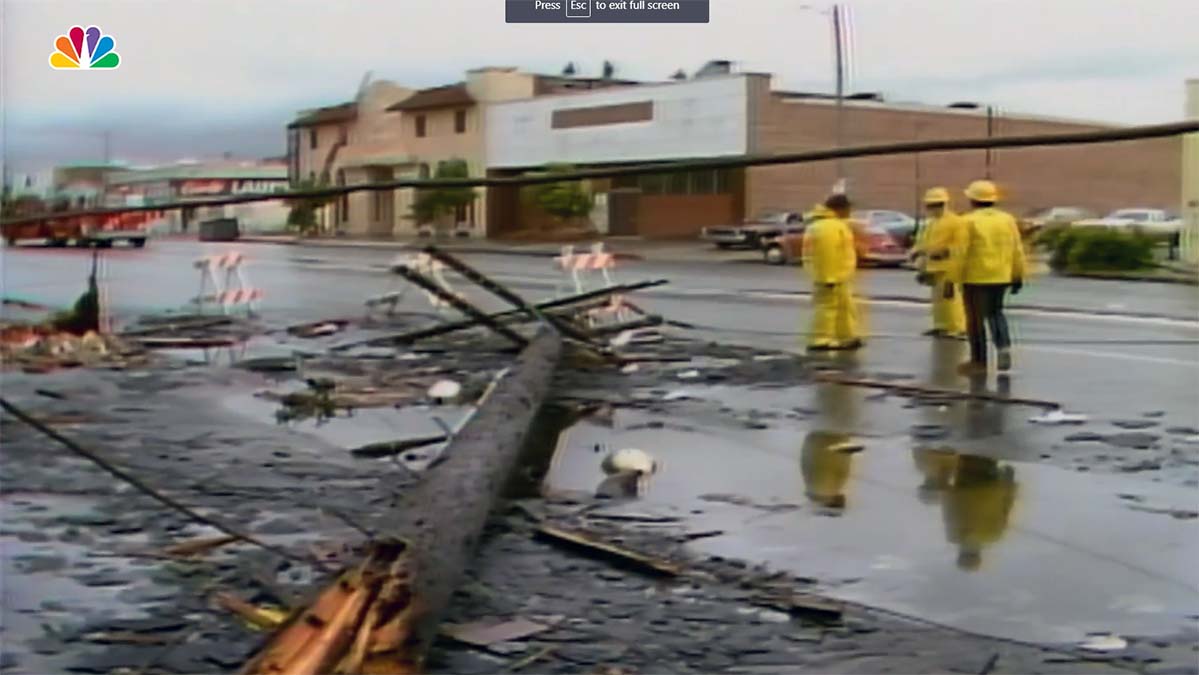
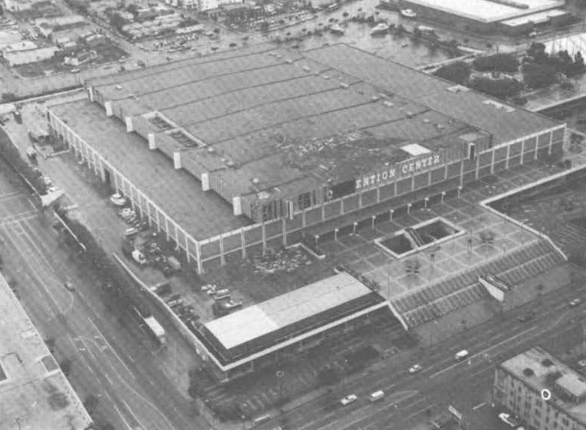
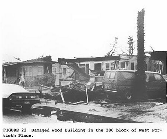
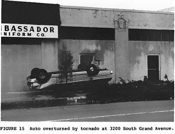
On March 1, 1983, a storm system fueled by the record setting El Nino event of the time spawned two tornadoes in Southern California. The more notable of the two is the infamous tornado that struck neighborhoods near Downtown Los Angeles. Sources greatly conflict as to when the tornado first touched down, but it was at some point from 7:40 to 10:15 AM, and tracked NNE for about 3.5 miles. Many vehicles including large trucks were overturned, many homes and businesses were severely damaged including some that had their roofs and some exterior walls torn off, power poles were snapped, and the Los Angeles Convention Center was severely damaged, with $2.5 million worth of damage occurring there alone. Thirty people were injured, mostly (but not exclusively) minor injuries from flying glass. A second tornado (rated F0) also touched down in Pasadena. Not much information is available on this tornado, though John Baker's car was reportedly lifted 15 feet into the air by the funnel; he luckily escaped serious injury. In Santa Ana, some residents reported a third tornado struck that town, though this was never confirmed. The National Weather Service in Kansas City was enlisted to conduct damage surveys, with the Los Angeles tornado ultimately receiving an F2 rating.

Damage in Los Angeles
Los-Angeles-Building-Destroyed-by-Tornado.png

Los-angeles-damage-1983.jpg
Car-Overturned-by-Tornado.png

1983-la-tornado-pole.jpg

1983-la-tornado-convention-center-1-1.jpg


Many sources erroneously claim the Los Angeles tornado resulted in nine fatalities. This is untrue, although nine people were killed by massive flooding brought on by the same storm system that spawned the tornadoes. Grazulis does not list any fatalities and Tom Bradley, the mayor of L.A. at the time, stated no one was killed, although it is possible one person may have died from tornado-related injures after the event (need more information to confirm this, however). One indirect fatality can be definitively attributed to the tornado; an LAPD helicopter crashed at 51st and Broadway while surveying the damage path, resulting in the death of police officer Stuart Taira.
 
Back
Top