
Marshal79344
Member
Wall cloud of the Great Smoky EF4I don't think there are any pictures of the Great Smoky Mountains tornado as it occurred at night and was rainwrapped.

Follow along with the video below to see how to install our site as a web app on your home screen.
Note: This feature may not be available in some browsers.
Wall cloud of the Great Smoky EF4I don't think there are any pictures of the Great Smoky Mountains tornado as it occurred at night and was rainwrapped.
That's the closest we're gonna get to a photo of that thing, I guess. Where'd you find the photo of Hackleburg near Carter Gin and that photo of Cullman crossing the river?Wall cloud of the Great Smoky EF4
View attachment 5826
Some rare 4.27 photos I've found
End of the Cullman Tornado. The tornado dissipated immediately after it had finished crossing this river.
View attachment 5815
The formation of the Flat Rock Tornado
View attachment 5816
The formation of the Rainsville Tornado
View attachment 5817
The Ringgold Tornado at EF4 strength in the Apison, TN area
View attachment 5818
A view under the wall cloud of the Bridgeport, AL EF4
View attachment 5819
The Hackleburg Tornado near the Carter Gin Subdivision (the final area of EF4+ damage along the path)
View attachment 5820
The Cordova Tornado's wall cloud structure
View attachment 5821
The Shoal Creek Tornado approaching the Ohatchee area
View attachment 5822
A view of the Rainsville Tornado in its mature stage, as seen from Fort Payne, AL
View attachment 5824
The horrific Tuscaloosa Tornado
View attachment 5825
Pretty sure that second pic is of Tuscaloosa, not Flat Rock.Some rare 4.27 photos I've found
End of the Cullman Tornado. The tornado dissipated immediately after it had finished crossing this river.
View attachment 5815
The formation of the Flat Rock Tornado
View attachment 5816
The formation of the Rainsville Tornado
View attachment 5817
The Ringgold Tornado at EF4 strength in the Apison, TN area
View attachment 5818
A view under the wall cloud of the Bridgeport, AL EF4
View attachment 5819
The Hackleburg Tornado near the Carter Gin Subdivision (the final area of EF4+ damage along the path)
View attachment 5820
The Cordova Tornado's wall cloud structure
View attachment 5821
The Shoal Creek Tornado approaching the Ohatchee area
View attachment 5822
A view of the Rainsville Tornado in its mature stage, as seen from Fort Payne, AL
View attachment 5824
The horrific Tuscaloosa Tornado
View attachment 5825
Collection of lesser-known vids from 4/27/11:
Two videos of Smithville when it was in the Shottsville, AL area after crossing the state line. As can be seen, it narrowed quite a bit but was still fairly strong:
1.
2.
3.
Another video of Smithville when it was in the Hamilton, AL area (heads up for annoying music):
These next 2 are of Cullman:
These 2 videos of Cullman demonstrate how it had a shifting appearance when it was going through Cullman, by the time it got to Arab it was a more traditional Dixie wedge. The horizontal vortices and multiple vortices are clearly visible on this thing, a rarity for Dixie Alley. Also, it one of the videos it appears to lack a visible condensation funnel for a brief period, simialr to the DePauw, IN F5 of 1974 and the Henryville, IN EF4 of 2012.
1.
2.
Those are some great pictures. I think that I’ve only seen about two of them... and I thought that I’d seen just about every picture from 4/27/2011.Some rare 4.27 photos I've found
End of the Cullman Tornado. The tornado dissipated immediately after it had finished crossing this river.
View attachment 5815
The formation of the Flat Rock Tornado
View attachment 5816
The formation of the Rainsville Tornado
View attachment 5817
The Ringgold Tornado at EF4 strength in the Apison, TN area
View attachment 5818
A view under the wall cloud of the Bridgeport, AL EF4
View attachment 5819
The Hackleburg Tornado near the Carter Gin Subdivision (the final area of EF4+ damage along the path)
View attachment 5820
The Cordova Tornado's wall cloud structure
View attachment 5821
The Shoal Creek Tornado approaching the Ohatchee area
View attachment 5822
A view of the Rainsville Tornado in its mature stage, as seen from Fort Payne, AL
View attachment 5824
The horrific Tuscaloosa Tornado
View attachment 5825
It was rated high-end EF3 in the Hamilton area. In fact there was a frame home at the bottom of a ravine that was swept clean from its foundation but lack of road access prevented close inspection of the home's construction, precluding a potential higher rating at that location. So it was likely at least EF4 at that point.I hadn’t seen the third video there of the Smithville Tornado near Hamilton, AL. It was still pretty robust at that point. I know that tornado only caused EF3 damage in AL... but I wonder if, at that point in the third video if it was still capable of producing EF5 damage if it had hit some sufficient DI’s.
I don’t know if I’ve mentioned this or not, but I really appreciate your contributions to this thread. I usually come here every day to see what else is here. So thanks for what you do here.
In fact, I thank everyone who helps keep this thread active. It is much appreciated to all.
It's from Flat Rock. Flat Rock formed on the other side of the river of Scottsboro, which is a pretty big city. This is where the image was taken. I did reverse search, which yielded nothing.Pretty sure that second pic is of Tuscaloosa, not Flat Rock.
Ok gotcha. Looks identical to Tuscaloosa as it entered the city. I guess a lot of the tornadoes that day were very similar in appearance at certain points.It's from Flat Rock. Flat Rock formed on the other side of the river of Scottsboro, which is a pretty big city. This is where the image was taken. I did reverse search, which yielded nothing.


Definitely some wind-rowing and debris granulation in that field picture. Tupelo 1936 was by all accounts, an extremely violent tornado. I just wish there were more clear pictures available.Surprised a substantial post about this tornado hasn't been made yet, so given we're discussing Dixie Alley events yet again I figured I might as well put up some information involving the 1936 Tupelo tornado, which is easily one of the worst Dixie events. Also, a one-year old baby with name of Elvis Aaron Presley was among the survivors.
Some damage pics:
1. Aerial views of damage in Tupelo. At left, the devastation around Gum Pond. Possible vegetation scouring is visible atop the mound at right center. At right, looking northeast at the tornado’s path through the city.
View attachment 5828
2. Views of damage in Tupelo. At left, the remains of homes and a tree that was stripped bare by Gum Pond. At bottom right, only sections of baseboard remain where a home once stood.
View attachment 5829
3. At left, complete devastation in the eastern section of town. At right, a heavily damaged mansion that was similar to nearby residences that were reduced to their foundations. The three-story Hoffman house at 365 North Church Street was swept completely away, leading to several fatalities.
View attachment 5830
4. At left, the remains of the Hoffman mansion, which was swept down to its baseboards. Homes across the street suffered relatively modest damage. At right, a field that was “stripped bare” just east of town. (Mississippi State Geological Survey, 1936)
View attachment 5831
5. This next two speak for themselves:
View attachment 5833 View attachment 5834
Sources:
1. https://www.tornadotalk.com/tupelo-ms-f5-tornado-april-5-1936/
2. https://extremeplanet.wordpress.com...est-tornadoes-ever-recorded-pre-1970-part-ii/
3. https://www.mdeq.ms.gov/geology/wor...ategories/bulletins/the-tupelo-tornado-18398/
Another bad Dixie Alley outbreak.Surprised a substantial post about this tornado hasn't been made yet, so given we're discussing Dixie Alley events yet again I figured I might as well put up some information involving the 1936 Tupelo tornado, which is easily one of the worst Dixie events. Also, a one-year old baby with name of Elvis Aaron Presley was among the survivors.
Some damage pics:
1. Aerial views of damage in Tupelo. At left, the devastation around Gum Pond. Possible vegetation scouring is visible atop the mound at right center. At right, looking northeast at the tornado’s path through the city.
View attachment 5828
2. Views of damage in Tupelo. At left, the remains of homes and a tree that was stripped bare by Gum Pond. At bottom right, only sections of baseboard remain where a home once stood.
View attachment 5829
3. At left, complete devastation in the eastern section of town. At right, a heavily damaged mansion that was similar to nearby residences that were reduced to their foundations. The three-story Hoffman house at 365 North Church Street was swept completely away, leading to several fatalities.
View attachment 5830
4. At left, the remains of the Hoffman mansion, which was swept down to its baseboards. Homes across the street suffered relatively modest damage. At right, a field that was “stripped bare” just east of town. (Mississippi State Geological Survey, 1936)
View attachment 5831
5. This next two speak for themselves:
View attachment 5833 View attachment 5834
Sources:
1. https://www.tornadotalk.com/tupelo-ms-f5-tornado-april-5-1936/
2. https://extremeplanet.wordpress.com...est-tornadoes-ever-recorded-pre-1970-part-ii/
3. https://www.mdeq.ms.gov/geology/wor...ategories/bulletins/the-tupelo-tornado-18398/


I did some research into the 1936 Tupelo Tornado not too long ago. The supercell thunderstorm that produced the Tupelo Tornado was hugging the warm front (according to Jonathan Finch's analysis), and benefiting from enhanced conditions along there. It's likely that other supercells existed further south in the warm sector, but were not tornadic. The supercell was filled with heavy rain, not surprised as the supercell was riding the warm front. This means that the tornado would have been more low-based than other supercells that day, and hard to see, which I did not confirm. The precipitation generated by the supercell would also have been higher than usual, due to its proximity to the front. The rain surrounding the tornado and directly succeeding it was unusually heavy, but not before. Eyewitnesses described multiple funnels spinning around a common center shortly after the Tupelo Tornado formed, and described large pieces of debris being chucked into the air within a minute of touchdown.
The tornado then grew into what I estimate to have been a low based wedge tornado, not too big, but of EF5 intensity as it began to move right into the heart of Tupelo, leveling entire brick businesses to the ground. So much debris filled the Tupelo Tornado as it moved through town at maximum intensity, that it was described as a rotating ball of fire, filled with terrible flashes (tons of power flashes.) Another eyewitness said, "I looked out the door and saw it coming. It looked like a ball of fire was whirling toward us. The air roared like a cannon. Then it struck. The roof came off, the walls came down, and we were buried under wreckage. The roar died down, and then I heard by neighbors groaning. My next-door neighbor died in my arms."
There was so much debris in the tornado that farm fields outside of Tupelo were strewn with debris for miles. The same supercell produced one more tornado after the Tupelo Tornado lifted.
Higher Quality aerial of the Gum Pond area, which was worst hit
View attachment 5835
Phenomenal destruction along some road in Tupelo
View attachment 5836
Tree Debarked
View attachment 5837
Another view of Gum Pond
View attachment 5838
View attachment 5839
View attachment 5840
View attachment 5841
Aerial of Tupelo
View attachment 5842


.jpg")
.jpg")

.jpg")
Probably because of how the newspaper was scanned.Those images have a surreal kind of quality to them, with the stark contrast levels. They almost look like charcoal drawings rather than photographs.
Making the issue worse is that many damage pics from Gainesville, Georgia tornado that occurred the next day are often incorrectly identified as being from Tupelo.Definitely some wind-rowing and debris granulation in that field picture. Tupelo 1936 was by all accounts, an extremely violent tornado. I just wish there were more clear pictures available.

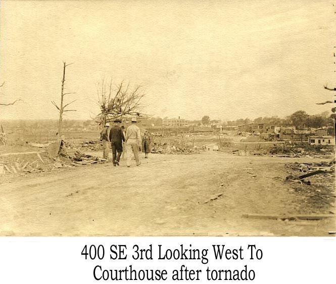
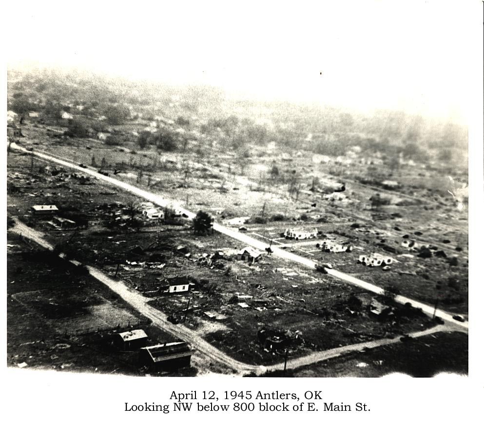
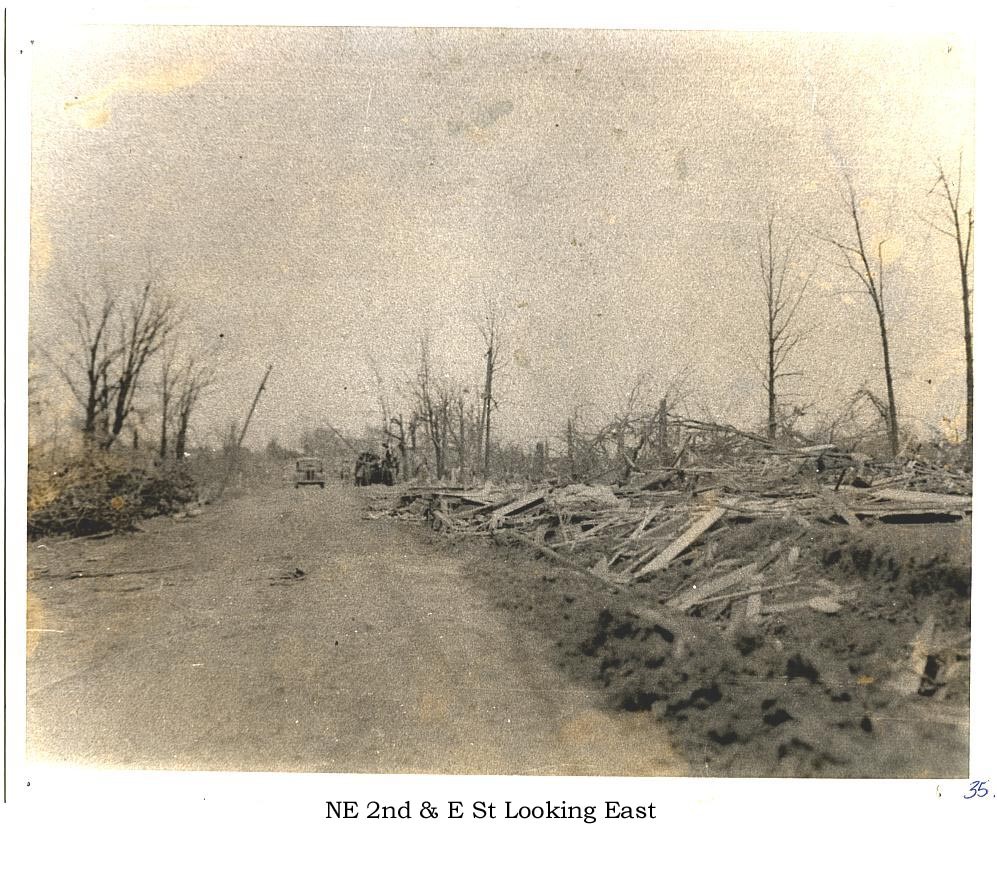
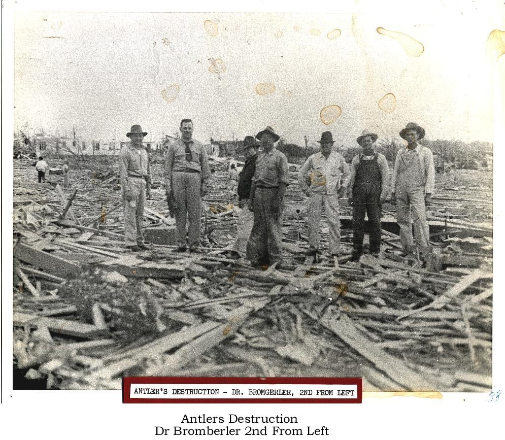
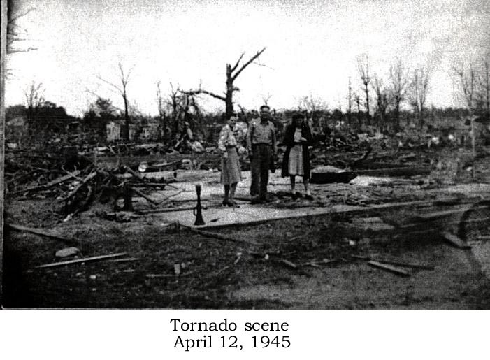
It looks like a bunch of the photos you uploaded aren't showing up, at least on my end. Not sure why.One tornado that has always interested me was the Antlers, OK F5 of of 1945. There aren't many photos available, though the descriptions of the damage that I have heard suggest that this was an extremely violent tornado. Not only were sections of some neighborhoods reportedly completely swept clean, but four brick businesses at an intersection in downtown Antlers were entirely swept away as well. Several other brick buildings were leveled, and a tractor trailer was thrown one mile and severely mangled. Debris from Antlers was strewn for up to 10 miles outside of town, and the bodies of victims were thrown long distances as well.
Another interesting note, is that I found one account indicating that the roar of the tornado was audible for up to 25 miles away! Not sure how accurate that is though.