
Thanks for the info.The second and seventh photo was from the first photo area and the third photo was from airport. The last two photo were probably from this area, west of Sullivan.
View attachment 22263
View attachment 22264
I am not sure about the fourth and fifth photo but it's likely near the first picture area.
Navigation
Install the app
How to install the app on iOS
Follow along with the video below to see how to install our site as a web app on your home screen.
Note: This feature may not be available in some browsers.
More options
-
Welcome to TalkWeather! We see you lurking around TalkWeather! Take the extra step and join us today to view attachments, see less ads and maybe even join the discussion. CLICK TO JOIN TALKWEATHER
You are using an out of date browser. It may not display this or other websites correctly.
You should upgrade or use an alternative browser.
You should upgrade or use an alternative browser.
Significant Tornado Events
- Thread starter locomusic01
- Start date
This feature reminds me of Mayfield. It had a pretty well defined core before entering into townSatellite imagery like that image shows a well pronounced vortex and centerline (along with some very impressive wind-rowing as it enters town) but then when it gets to Greensburg it kind of just disappears I guess lol.

When it entered into town, it suddenly became very complex and wide multivortex structure.


- Thread starter
- #9,983
locomusic01
Member
Sorta given up hope of any of it ever turning up, but I still reach out to some of the people who supposedly have them every now and then. Most just don't answer, or if they do it's usually with some kind of excuse. Same thing happened with a few people who had photos (or said they did, at least) from the non-Moore tornadoes on 5/3/99. I dunno why people do that but I've kinda come to expect it at this point.Sorry if beating a dead horse but did you get any more photos from 5/31/85? Anything more of Niles-Wheatland, videos of Kane/Atlantic/Albion or the holy grail; a photo of Moshannon State Forest. Or is that stuff pretty much gone the way of the buffalo?
That actually reminds me though - I did randomly get a message a couple weeks ago from one of the emergency management people in Niles I'd contacted back when I was researching the article. I don't think I replied to him at the time because I wasn't feeling very well so I'll have to make a note of it. From what I understand one of the EM guys had a pretty big collection of photos so I'm hoping either it's him or he knows who it is.
Incidentally, I did come across a couple random pics from the Atlantic tornado recently. Not the tornado itself unfortunately, but IIRC these are from the area around Lake Creek Rd. just north of Cooperstown. I believe one of the cars came from the property of Betty Zinz, who I mentioned briefly in the article. I know at least one vehicle in that area was hurled something like 300 or 400 yards.


joshoctober16
Member
so question to anyone here, any one have the link to the tweet or post or paper that states el reno 2011 would not be rated EF5 today?
and the one paper that talks about the 2 EF4 from that same day that state bridge creek may 1999 would only be rated a 200 mph EF4 today? i wish i could re find them.
and the one paper that talks about the 2 EF4 from that same day that state bridge creek may 1999 would only be rated a 200 mph EF4 today? i wish i could re find them.
so question to anyone here, any one have the link to the tweet or post or paper that states el reno 2011 would not be rated EF5 today?
and the one paper that talks about the 2 EF4 from that same day that state bridge creek may 1999 would only be rated a 200 mph EF4 today? i wish i could re find them.

joshoctober16
Member
oh well ty i guess i sort of found it a hour ago but im looking for the presentation of this as i clearly remember seeing a clip of this. but hey thanks anyhow
Western_KS_Wx
Member
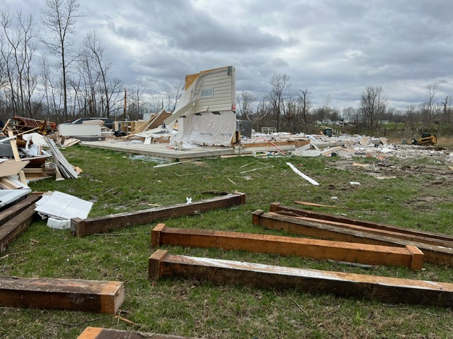
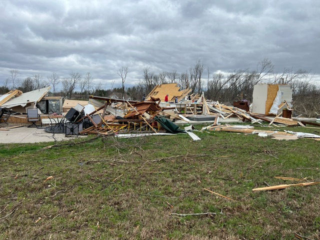
Those Sullivan photos, good lord. I’ve never actually looked into the tornado that much but knew it was probably stronger than its official rating, however I had no clue it was that violent. Glad they’re looking into it again because there’s clearly EF4+ damage in several locations, kind of makes me wonder how they didn’t catch all of that the first time.The second and seventh photo was from the first photo area and the third photo was from airport. The last two photo were probably from this area, west of Sullivan.
View attachment 22263
View attachment 22264
I am not sure about the fourth and fifth photo but it's likely near the first picture area.
TH2002
Member
- Messages
- 4,973
- Reaction score
- 11,113
- Location
- California, United States
- Special Affiliations
- SKYWARN® Volunteer
@bowecho7 I picked up on a property located about a quarter mile south of the EF3/160 home DI on IL-1. In the attached video, the property can be seen best at the 19:20-19:25 mark, and again at the 19:47 mark. Photo for reference:

Coordinates: 38°59'47.69"N 87°41'6.92"W
Another property off East 1150th Ave (coordinates: 39° 1'7.62"N 87°37'18.54"W) that got slabbed can be seen at about 13:19 in the video. I don't know what the buildings were (they may have all been outbuildings) but it may be worth checking out.
Coordinates: 38°59'47.69"N 87°41'6.92"W
Another property off East 1150th Ave (coordinates: 39° 1'7.62"N 87°37'18.54"W) that got slabbed can be seen at about 13:19 in the video. I don't know what the buildings were (they may have all been outbuildings) but it may be worth checking out.
Last edited:
Juliett Bravo Kilo
Member
Those Sullivan photos, good lord. I’ve never actually looked into the tornado that much but knew it was probably stronger than its official rating, however I had no clue it was that violent. Glad they’re looking into it again because there’s clearly EF4+ damage in several locations, kind of makes me wonder how they didn’t catch all of that the first time.
They probably did catch them all the first time, they were just pressured to go with a lower rating....
Juliett Bravo Kilo
Member
Sorta given up hope of any of it ever turning up, but I still reach out to some of the people who supposedly have them every now and then. Most just don't answer, or if they do it's usually with some kind of excuse. Same thing happened with a few people who had photos (or said they did, at least) from the non-Moore tornadoes on 5/3/99. I dunno why people do that but I've kinda come to expect it at this point.
That actually reminds me though - I did randomly get a message a couple weeks ago from one of the emergency management people in Niles I'd contacted back when I was researching the article. I don't think I replied to him at the time because I wasn't feeling very well so I'll have to make a note of it. From what I understand one of the EM guys had a pretty big collection of photos so I'm hoping either it's him or he knows who it is.
Incidentally, I did come across a couple random pics from the Atlantic tornado recently. Not the tornado itself unfortunately, but IIRC these are from the area around Lake Creek Rd. just north of Cooperstown. I believe one of the cars came from the property of Betty Zinz, who I mentioned briefly in the article. I know at least one vehicle in that area was hurled something like 300 or 400 yards.
Atlantic, Albion or Kane? Was at least one these taped from a distance? Was it the same one or another one where the multivortex structure of it was visible while touching down?
Also what was the Moshannon photo reputedly like? Was it when the tornado was first touching down or was it when it was fully wedged out while going through the forest areas?
Marios Wallace
Member
The last two are just SW of SullivanI've seen most of these pics, however I do not recognize the last two. The small picture is from the airport. However, are the rest of them from the same location, the house across the street from the college on Hwy 1? Are the last two from the same house across from the college or from Sullivan? Any help appreciated.
Side note, but I can't tell you how pleasing it is to see NWS mets chime in here and wanting to gather/exchange information about tornado damage that has been documented by the posters in this thread.Thanks for the info.
@bowecho7 I picked up on a property located about a quarter mile south of the EF3/160 home DI on IL-1. In the attached video, the property can be seen best at the 19:20-19:25 mark, and again at the 19:47 mark. Photo for reference:
View attachment 22285
Coordinates: 38°59'47.69"N 87°41'6.92"W
Another property off East 1150th Ave (coordinates: 39° 1'7.62"N 87°37'18.54"W) that got slabbed can be seen at about 13:19 in the video. I don't know what the buildings were (they may have all been outbuildings) but it may be worth checking out.
22:06 into this video, there's a home that looks to have been completely swept away south of Robinson that I believe was not able to be accessed by survey teams. Off N White Tail Hollow Road.
Juliett Bravo Kilo
Member
Sounds like another Vilonia....22:06 into this video, there's a home that looks to have been completely swept away south of Robinson that I believe was not able to be accessed by survey teams. Off N White Tail Hollow Road.
TH2002
Member
- Messages
- 4,973
- Reaction score
- 11,113
- Location
- California, United States
- Special Affiliations
- SKYWARN® Volunteer
If I'm not mistaken, the White Tail Hollow home is this one on the DAT, which was given a 165MPH wind speed estimate due to being poorly anchored:22:06 into this video, there's a home that looks to have been completely swept away south of Robinson that I believe was not able to be accessed by survey teams. Off N White Tail Hollow Road.
TH2002
Member
- Messages
- 4,973
- Reaction score
- 11,113
- Location
- California, United States
- Special Affiliations
- SKYWARN® Volunteer
The fact that someone from NWS Lincoln is actually listening to our critiques of the Robinson survey puts this in a more reasonable tier than Vilonia IMO. To this day NWS Little Rock has taken absolutely no initiative to reanalyze Vilonia, much less upgrade it - and I'd imagine any email sent to them with "Vilonia" or "EF5" in the subject line goes straight to the trash folder.Sounds like another Vilonia....
Ah ok that one was added retroactively, good stuff.If I'm not mistaken, the White Tail Hollow home is this one on the DAT, which was given a 165MPH wind speed estimate due to being poorly anchored:
- Thread starter
- #9,998
locomusic01
Member
Yeah, that was Albion. Richard Bomboy got it on a camera mounted atop a high-gain antenna just after it tore through Jumbo Woods (now State Game Lands 101). It was rather large and intense with a pronounced multivortex structure. The path at that point was just under half a mile wide (marked the location of the antenna/camera from memory so it's prolly not exact):Atlantic, Albion or Kane? Was at least one these taped from a distance? Was it the same one or another one where the multivortex structure of it was visible while touching down?
Also what was the Moshannon photo reputedly like? Was it when the tornado was first touching down or was it when it was fully wedged out while going through the forest areas?

Re: Moshannon, I'll have to go back and check the woman's messages, but I don't remember her ever saying exactly where the photo was taken or what it looked like. Well, other than it was very big obviously. I think she said her parents took it from the highway (maybe?) which would presumably be either PA 153 near Penfield (where it was transitioning from a half-mile-wide stovepipe to a mile-wide wedge), Quehanna Hwy near the PermaGrain facility (~1.25 miles wide) or PA 144 east of Keating (over 2 miles wide). Quehanna Hwy seems most likely if I'm remembering it right but I dunno.
Juliett Bravo Kilo
Member
Yeah, that was Albion. Richard Bomboy got it on a camera mounted atop a high-gain antenna just after it tore through Jumbo Woods (now State Game Lands 101). It was rather large and intense with a pronounced multivortex structure. The path at that point was just under half a mile wide (marked the location of the antenna/camera from memory so it's prolly not exact):
Re: Moshannon, I'll have to go back and check the woman's messages, but I don't remember her ever saying exactly where the photo was taken or what it looked like. Well, other than it was very big obviously. I think she said her parents took it from the highway (maybe?) which would presumably be either PA 153 near Penfield (where it was transitioning from a half-mile-wide stovepipe to a mile-wide wedge), Quehanna Hwy near the PermaGrain facility (~1.25 miles wide) or PA 144 east of Keating (over 2 miles wide). Quehanna Hwy seems most likely if I'm remembering it right but I dunno.
Was the multivortex structure taken shortly after this? FYI this pic is only accessible if you click on the Jumbo Woods aerial, not in your article itself. Also, I found the guy's obituary; seems like he died over a decade ago so likely this footage he captured is lost to time. Shame.
Re: Moshannon. I'm amazed someone was able to get a pic of it so far out in the boonies (assuming what this woman told you is true) but why they told you they'd give it to you then don't is a mystery. Maybe some staff who work for the forestry department in the areas might have some pics of it but who knows?
I'd love to find color aerials and ground-level views of the forest damage done by Kane, although that's likely a loosing proposition as well.

- Thread starter
- #10,000
locomusic01
Member
His family apparently still has the tape, I just haven't been able to get my hands on it yet. And that's one of a few photos I didn't include in my article because I got conflicting info on them and wasn't able to 100% confirm where or when they were taken. I originally got it from a librarian in Albion and she said it was taken down near the OH/PA border, which is a few miles SW of Jumbo Woods. Another local guy said it was taken just outside of Cranesville. And then I've also seen it labeled as being the long-track F2 that struck near Beaver Center on June 22. The latter may actually be most likely since it closely resembles some of the other photos from that tornado.Was the multivortex structure taken shortly after this? FYI this pic is only accessible if you click on the Jumbo Woods aerial, not in your article itself. Also, I found the guy's obituary; seems like he died over a decade ago so likely this footage he captured is lost to time. Shame.
Re: Moshannon. I'm amazed someone was able to get a pic of it so far out in the boonies (assuming what this woman told you is true) but why they told you they'd give it to you then don't is a mystery. Maybe some staff who work for the forestry department in the areas might have some pics of it but who knows?
I'd love to find color aerials and ground-level views of the forest damage done by Kane, although that's likely a loosing proposition as well.
View attachment 22497