• Welcome to TalkWeather!
    We see you lurking around TalkWeather! Take the extra step and join us today to view attachments, see less ads and maybe even join the discussion.
    CLICK TO JOIN TALKWEATHER
  • April 2024 Weather Video of the Month
    Post your nominations now!

Nightking2021

Member
Messages
66
Reaction score
29
Location
Wichita, Kansas
Some more Andover pics from Storm Data and assorted documentaries:


Claus Steueve's is on your blog article, but I've never seen the rest of these before. I'm always looking for more photos from the Missouri portion of the path, partly cuz I'm a Missouri native and partly because this portion of the path wasn't as well
The Tri-State 1925 tornado is probably one of the most violent tornadoes especially pre 1970s.
 

MNTornadoGuy

Member
Messages
1,625
Reaction score
2,599
Location
Apple Valley, MN
One of the strangest Plains tornado outbreaks was the November 4, 1922 Mid-Plains tornado outbreak. Not only did the outbreak occur late in the year and early in the day (the first tornado occurred at 5 am), the tornadoes themselves were very intense. The first event was a very long-tracked F3+ tornado family that tore across Crowley and Lincoln Counties in Colorado. Buildings were swept away from over a dozen farms and four people were killed in one farm-house. The second event was an F3 that struck rural areas near Amherst CO. A school and farm were destroyed resulting in one fatality. The third event was an F2+ that struck SE of Minneola KS that destroyed farmhouses and swept a roadside "clean of grass and weeds." The 5th event was a violent F4 tornado that struck near Shamrock OK. Frail homes and pieces of over 130 oil rigs were scattered for miles. 11 people were killed by this tornado, mostly oil workers. There was also an F2 tornado in Nebraska that destroyed one barn.
https://www.tornadotalk.com/shamrock-drumright-ok-f4-tornado-november-4-1922/
 

locomusic01

Member
Messages
1,361
Reaction score
3,793
Location
Pennsylvania
Same here, although I have seen photographs with intense damage in the background so it could be a case of the extreme damage wasn't photographed all that much which seems to be a common problem with older events.
It's extremely common, to the point that I'd actually say it's fairly rare for the most intense damage to be extensively photographed (if at all). Which makes sense when you think about it: the most extreme damage is often going to consist of structures being completely swept away and/or debris being granulated. Unless you know what you're looking at, that doesn't tend to make a very compelling visual. To the average person, it's way more intriguing to see homes ripped in half, big heaps of debris, random projectiles stuck into things, etc.

On the other hand, stuff being swept cleanly away and smashed to tiny bits does make a compelling story, which is why you can usually at least find accounts of the worst damage written down somewhere.
 
Messages
2,235
Reaction score
2,825
Location
Missouri
It's extremely common, to the point that I'd actually say it's fairly rare for the most intense damage to be extensively photographed (if at all). Which makes sense when you think about it: the most extreme damage is often going to consist of structures being completely swept away and/or debris being granulated. Unless you know what you're looking at, that doesn't tend to make a very compelling visual. To the average person, it's way more intriguing to see homes ripped in half, big heaps of debris, random projectiles stuck into things, etc.

On the other hand, stuff being swept cleanly away and smashed to tiny bits does make a compelling story, which is why you can usually at least find accounts of the worst damage written down somewhere.
Stuff like this makes me wonder about accounts of older events, particularly Dixie events. I once used to always think that accounts of plantations or large farms and villages either 'vanishing', 'obliterated' or 'blown to atoms' were mere exaggeration. Of course with the funeral home vanishing at Smithville it clearly isn't an exaggeration to say that it literally vanished. I'm sure a photographer a century ago may not recognize these impressive feats as damage anyways or, if they were from a neighboring town over or far away city wouldn't have recognized the proper locations for these landmarks and thus didn't think to visit or photograph them. Who knows?
Even today, media coverage of tornadoes typically doesn't show anything higher than EF3, at least usually. The more extreme instances of damage you have to track down via storm surveys and the like.
 

Marshal79344

Member
Messages
361
Reaction score
1,066
Location
Chicago, IL
Hurricane Tornado setups are always a hit or miss. It's always a question if mesoscale-wise, can tornadic supercells form along with the outer bands of the hurricane at the perfect time before they become too weak? Instability is usually the missing factor, but if warm air, in general, is present ahead of an approaching hurricane, that will serve to boost the outbreak's potential. Hurricane-spawned tornadoes can also last pretty long too, some of which have tracked over 40 miles. This post will take a look at some hurricane-spawned tornadoes I have in my archives.

By far the worst hurricane-spawned tornado that I know of occurred on October 3rd, 1964, when the landfalling hurricane Hilda generated a tornadic supercell from its bands, which dropped a violent tornado right of Larose, Louisiana. The quick-hitting tornado was only down for less than two miles, but in that time span, it leveled several homes and killed 22 people. ERA5 reanalysis depicts some unusually high instability for a hurricane setup. It takes some time to get used to the weird hodograph and the wind profiles, but that's typical of northeastern flow tornado setups, such as the 1987 Edmonton Tornado, and tropical cyclones. There were likely more tornadoes, but Larose is the only city located in what mostly is a marshy area. Although the lower level lapse rates are marginal, the kinematics associated with a hurricane, especially a Category 4 like Hilda, is easily strong enough to sustain storms in weaker thermodynamic environments.

19641003.png

As typical with most hurricane setups, the tornado would have been very low based and hard to see coming. Here are some of the damage photos I have from that tornado.

19641003LAROSE10.PNG19641003LAROSE.PNG19641003LAROSE8.PNG

Another significant tornado event occurred with the famous "wrong-way" hurricane, also known as Lenny, off of Puerto Rico in 1999. All tropical cyclones are constantly evolving new bands and supercells throughout their lifespans, which makes it a guarantee that there were several, possibly even hundreds of waterspouts generated by tropical cyclones that thankfully hit nothing. Here are some radar pictures of some likely strong waterspouts off of Puerto Rico in association with Lenny. I am going to dive further into the world of offshore tornadoes in a later post.

19991117LENNY2.png
19991117.png

The third of the five events I am going to talk about occurred in association with Hurricane Ivan on September 17th, 2004. A long-tracked, cyclic supercell dropped two noteworthy tornadoes. The first touched down in a rural area, but the rotational signature associated with that tornado was very, very high-end. I am GLAD it remained in rural areas. Here is the radar scan of the first tornado below.

20040915IVAN.png

The next tornado touched down near the city of Blountstown, FL, which is no stranger to both non-tropical cyclone-related and tropical cyclone-related tornadoes. It passed very close to the city, striking two mobile homes and killing two people.

Radar scan of that tornadic storm:

20040915BLOUNTSTOWN.png


Scar left behind from that tornado:

20040915BLOUNTSTOWN.PNG
 

Marshal79344

Member
Messages
361
Reaction score
1,066
Location
Chicago, IL
It's a proven fact that tropical cyclone-related tornadoes can occur with any tropical cyclone anywhere in the world. This was never more true than on October 4, 2015, when the landfalling Typhoon Mujigae spawned a long-tracked and intense EF3 Tornado that did severe damage to several buildings in the Foshan, China area. This tornado was caught on video and displayed a very cool horizontal vortex, a testament to the high shear levels that tropical cyclones generate.

Photos of the tornado itself:

20151004TCEF3FUNNEL6.jpg
20151004TCEF3FUNNEL.PNG

China has become very, VERY good at documenting recent intense tornadoes, conducting in-depth surveys, and actually making an effort to understand more about their tornadoes.

Here are two survey pictures (Edit: One of them refuses to load onto this site for some reason)

20151004TCEF3TRACK.PNG

China also has a non-public NEXRAD radar system, which can read data into programs such as GR2Analyst. Here is a scan of the supercell responsible for the Foshan Tornado.

20151004TCEF3RADAR3.PNG

The final event occurred last year, with Hurricane Isaias. Due to warm air already invading the USA prior to the hurricane's occurrence, instability values were aided, helping to increase the severity of the outbreak. In addition, the hurricane moved north in a manner that would constantly allow it to regenerate tornadic supercells from its outer bands. The first major tornado was this large spout near Cape May:

20200804A.png

There was also another MAJOR waterspout offshore that occurred later that day. A supercell to the northeast of this one with a much weaker rotational signature dropped a wedge EF1 at Strathmere, NJ.

20200804.png

However, there were two supercells that were onshore that dropped very high-end tornadoes for hurricanes. The first occurred south of Windsor, NC. A lone, discrete supercell produced a very intense EF3 Tornado at nighttime that rampaged through a mobile home park, killing two people. A poorly built frame home was also swept away nearby. The mobile homes were in such bad condition that their frames had been thrown across the road or badly mangled. The same area also saw the effects of a violent tornado on April 16th, 2011.

The supercell on radar:

20200804TCEF3.png

Aerial view of the worst-hit area:

20200804WINDSOR4.png

The final of the two high-end tornadoes occurred southeast of Suffolk, VA, in a swamp. The supercell dropped a very large wedge tornado, with a 400 yard-wide contour of significant tree damage and clear sub vortex action, doing massive damage as it transversed through the forest. The tornado immediately weakened upon exiting the forest and did EF1 damage at Suffolk.

The supercell on radar:

20200804SUFFOLK.png

The MASSIVE tree scar left behind by the tornado:

20200804SUFFOLK.PNG
 

Marshal79344

Member
Messages
361
Reaction score
1,066
Location
Chicago, IL
Every year, there are countless high-end tornadoes and outbreaks that occur out of the reach of radar detection. However, radars will sometimes see some very intense velocity couplets every year, which likely indicates the presence of a high-end waterspout. Here are some of my best examples:

February 2, 1998. Had this thing been onshore, with a GTG velocity of 220+ mph instead of the Kissimmee Tornadoes 21 days later, there would have been so much more damage. I have a feeling that this tornado, had it been onshore, would not have been too far behind the Tennessee Tornado Family of April 16th in intensity, or possibly on par. Only one tornado of any significance occurred ashore that day, it was an EF2 at Miami with a much weaker velocity signature than any of these other tornadoes.

19980202VIOLENTTORNADO.png

The same supercell cycled a new tornado:

SpinningCell15B(ALSOVIOLENT).png

Another waterspout from the same event I found VERY impressive:

SpinningCell20.png

This one off of Bald Head Island, NC on May 29, 2001

20010529.png

This one in the Louisiana Marshes on April 6th, 2005

20050406A.png

This cyclic monster produced several likely intense tornadoes off of Alabama on February 23, 2016. The supercell complex produced one tornado ashore. That was an EF3 at Pensacola with a weaker velocity signature than several of those seen offshore.

20160223WORST2.png

This one off of Florida on June 6, 2016

20160606.png

This one off of Louisiana on April 25, 2019

20190425.png


This comma head had a very high-end velocity signature offshore (195.5 mph GTG) as it exited over the Tybee Island area. It even had a BWER, something RARELY seen in embedded supercells like this one.

20200413.png
 

Marshal79344

Member
Messages
361
Reaction score
1,066
Location
Chicago, IL
Here are a few more recent examples

April 20th, 2020 off of Florida:

20200420INTENSE.png

May 28, 2020 off of Galveston, TX. This had a large stovepipe waterspout with it.

20200528.png


August 25, 2020, in association with Tropical Storm Marcos

20200824.png

December 24, 2020 off of North Carolina
20201224.jpg

February 15, 2021 off of Florida

20210215F.png

20210215H.png
20210215D.png

March 18, 2021 off of North Carolina

20210318B.png20210318CA.png20210318.png
 

MNTornadoGuy

Member
Messages
1,625
Reaction score
2,599
Location
Apple Valley, MN
Oct/Nov is not usually associated with intense-violent tornadoes in Minnesota but it has happened multiple times in the past before. I will list the most notable of these events in chronological order (oldest to latest.)

1. Oct 6, 1900 Biwabik F3

This tornado not only occurred during October, but it also occurred in northern Minnesota. The tornado moved NW and N through the mining community of Biwabik. Railcars were thrown hundreds of feet, multiple homes (mostly owned by miner's families) were leveled or swept away with furniture being scattered for miles, mining buildings were blown down, and trees were ripped up and tossed through the air. The path through forests was reported as an "impassable pile of interlaced tree trunks and branches." This is also one of the deadliest tornadoes in Minnesota history with 10 deaths. 6 members of one family were killed in a single home that was swept away.

-
2. Oct 3, 1903 St Charles F4

This long-tracked violent tornado family moved NE from 3 miles W of Chatfield and passed through the town of St Charles. Seven people were killed as 50 buildings including homes were damaged or destroyed. Some homes in town were leveled, multiple brick buildings in downtown partially collapsed and trees were snapped/uprooted. The tornado(es) was probably more intense in Wisconsin where homes were swept away and 2 people died.

-
3. Nov 2, 1938 Nashwauk F2+

This is another significant Northern MN tornado to occur in Oct/Nov. This long-tracked tornado moved NE for 32 miles, moving a cabin 50 ft off its foundation, unroofing one home and blowing down thousands of trees. A railroad trestle was destroyed and a 3-inch plank was carried a half-mile. This tornado was likely stronger than an F2 at one point.

19381102_tornado_duluth_herald.jpg
 

buckeye05

Member
Messages
3,314
Reaction score
5,071
Location
Colorado
Where do you see these phenomena? Looking at available imagery, including aerial photography, I would concur that Fargo was certainly a violent tornado, but contextual evidence for (E)F5 damage is borderline at best. Ground scouring, wind-rowing, and vegetative impact(s) are relatively unimpressive, even compared to faster-moving, borderline (E)F5s such as Washington IL (11/17/2013). Plus, severe damage to vehicles and machinery is notably lacking, and a lot of debris remained in the vicinity of homesites. I think Fargo is a low-end, questionable F5 at best and would probably not be rated higher than a mid-range EF4 today.
I have nothing to say to you; besides what I already have. You lack the ability to accurately and objectively analyze tornado damage photographs, and any further discussion with you always has been and always will be, a waste of time.
 

speedbump305

Member
Messages
495
Reaction score
140
Location
Cypress Texas
I have nothing to say to you; besides what I already have. You lack the ability to accurately and objectively analyze tornado damage photographs, and any further discussion with you always has been and always will be, a waste of time.
saying fargo is a low end questionable F5 is such bullshit to me. like bruh. the images clearly show a very intense F5 that was well into the range.
 

Marshal79344

Member
Messages
361
Reaction score
1,066
Location
Chicago, IL
saying fargo is a low end questionable F5 is such bullshit to me. like bruh. the images clearly show a very intense F5 that was well into the range.
To be fair I think that person was looking at Fargo in the perspective as if would it be rated EF5 today. Fargo definitely deserves the F5 threshold, but I think they weren't too sure about an EF5 rating.
 
Messages
2,235
Reaction score
2,825
Location
Missouri
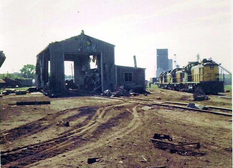
Damage from the 1968 Tracy MN tornado. The F5 damage might have occurred on farms instead of in town. Also included are some color photographs of the funnel itself. Some of these photos were taken after a bit of cleanup had occurred.
View attachment 7944


img


img

Amazed it took this long in the thread for Tracy to get a mention. I think the F5 rating may also be based on the damage it did at the train station/depot area on the edge. The buildings are still standing but a ton of heavy train cars were rolled/thrown some distances and the ground looks a bit torn up in some spots but not sure. Might be wrong.

 
Logo 468x120
Back
Top