• Welcome to TalkWeather!
    We see you lurking around TalkWeather! Take the extra step and join us today to view attachments, see less ads and maybe even join the discussion.
    CLICK TO JOIN TALKWEATHER
  • April 2024 Weather Video of the Month
    Post your nominations now!
Logo 468x120

Severe WX Severe Weather Threat - February 15-16, 2023

UncleJuJu98

Member
100,000th Post
Messages
4,079
Reaction score
5,354
Location
Birmingham
Was not expecting no tornado or even severe thunderstorm warnings in MS/AL/TN at 2120Z based this morning's HRRR runs, that's for sure.

Sent from my Pixel 4a using Tapatalk
I'm ready to hear treys breakdown , I've learned a lot by his videos alone.

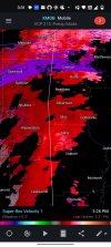
We still arent out of the woods yet. I'd watch for a sneaky tornado threat in south central / south Alabama moving forward.
 

Richardjacks

Member
Meteorologist
Messages
1,161
Reaction score
1,331
Location
Atop Red Mountain Birmingham, Al
Storm mode in central/south MS and into Alabama seems pretty messy right now. Wonder if that’s going to hinder things?
I am still concerned that as the low level jet ramps up a bit this evening, there will be enough instability remaining. We are still in February, so it doesn't take as much.
 

UncleJuJu98

Member
100,000th Post
Messages
4,079
Reaction score
5,354
Location
Birmingham
This cell near Silas is intriguing.. moving forward it may be one a issue.
 

Attachments

  • Screenshot_2023-02-16-15-32-02-52_d742e5e24846c0b0ac98c1cecc909937.jpg
    Screenshot_2023-02-16-15-32-02-52_d742e5e24846c0b0ac98c1cecc909937.jpg
    1.3 MB · Views: 0
  • Screenshot_2023-02-16-15-31-57-15_d742e5e24846c0b0ac98c1cecc909937.jpg
    Screenshot_2023-02-16-15-31-57-15_d742e5e24846c0b0ac98c1cecc909937.jpg
    1.3 MB · Views: 0

UncleJuJu98

Member
100,000th Post
Messages
4,079
Reaction score
5,354
Location
Birmingham
Extremely weak low level lapse rates may be some of our issue today. I remember them being forecasted to be around 6.5 to 7 for a good portion of central Alabama if I'm correct. Need more high lapse rates than that for any substantial rotation or storms.
 
Top