- Thread starter
- #541
Lake Martin EF4
Member
Awwwwwwwwwwwwwwww crumbs.For some reason I'm sensing a repeat of Southaven 2008 tonight...
Oops! We ran into some problems.
edit: gosh darnit
View attachment 17870
Follow along with the video below to see how to install our site as a web app on your home screen.
Note: This feature may not be available in some browsers.
Awwwwwwwwwwwwwwww crumbs.For some reason I'm sensing a repeat of Southaven 2008 tonight...
Oops! We ran into some problems.
edit: gosh darnit
View attachment 17870
What's a Southaven 2008?Awwwwwwwwwwwwwwww crumbs.
TW is finicky when attaching PNG's for some reason. It seems to work fine with JPG's so I usually use those despite the slightly lower quality.Awwwwwwwwwwwwwwww crumbs.
The Southaven-Memphis EF2 during the Super Tuesday outbreak.What's a Southaven 2008?
EF2 on February 5, 2008. Narrowly missed us. Killed 3 people at a warehouse and then severely damaged a mall.What's a Southaven 2008?
The "crumbs" comment was not directed at the PNG. I'd rather not get a midnight TOR-E on a school night.TW is finicky when attaching PNG's for some reason. It seems to work fine with JPG's so I usually use those despite the slightly lower quality.

The Southaven-Memphis EF2 during the Super Tuesday outbreak.
EF2 on February 5, 2008. Narrowly missed us. Killed 3 people at a warehouse and then severely damaged a mall.
I'm an idiot... my bad.The "crumbs" comment was not directed at the PNG. I'd rather not get a midnight TOR-E on a school night.
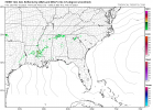
that's what is going to likely determine how the day goes..for Alabama.....that could be above the cap, but could also increase backing...a troublesome look if the cap breaks in timeSeems like a boudnary / confluence or something trains over the i59 corridor. May lead to erosion of the capping inversion sooner for that area. View attachment 17871
Memphis going live in 15 minutes
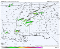
Seems like a overdone capping inversion by models. May mean a little further south initiation of some severe storms.Is it just me or has anyone else noticed how the short term model guidance particularly the HRRR appears to be lacking on the current activity south/west of Columbus, MS.
21z HRRR modeled vs. actual
Cape in most west Tennessee pushing 1500I'm an idiot... my bad.
Off hand I'm not sure what kind of parameters the 2008 tornado formed in, but it's looking increasingly like the Memphis metro could be in the bullseye of a high shear, low CAPE threat tonight (50-60 knts of shear and 300+ m2s2 spell bad news) if a storm can manage to root itself in the boundary layer. Definitely a perfect night to keep the weather radio close by...
Just curious - what site are you using to view the current parameters in place over that area? My body is still sore and mind still mush after having to deal with a bunch of 600-900 lb pallets by hand at work yesterday...Cape in most west Tennessee pushing 1500
Just noticed; was checking the simulated satellite imagery some of the semi decaying storms over Tennessee push out a outflow boundary or something. and kindve merges along the confluence band. Probably have a extreme amount localized shear along the i59 corridor area.that's what is going to likely determine how the day goes..for Alabama.....that could be above the cap, but could also increase backing...a troublesome look if the cap breaks in time

Short range I get off pivotJust curious - what site are you using to view the current parameters in place over that area? My body is still sore and mind still mush after having to deal with a bunch of 600-900 lb pallets by hand at work yesterday...
Interesting, the GFS model is showing some CAPE breaking 1,000 J/kg in extreme SW TN (in other words, the Memphis metro) but everywhere else in west TN seems to be in the 600-800 range. Or maybe I'm looking at the wrong page?Short range I get off pivot
Seems like a overdone capping inversion by models. May mean a little further south initiation of some severe storms.