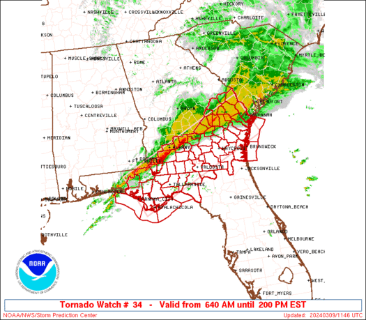
A bit surprised the hook + couplet to its immediate northeast is only SVR warned given it looks just as impressive on radar.Double twister
School night for me, gotta bend some rules to get past the 10pm bedtime so I can track this darn thing. I'm usually up by 7 regardless...Not sure that’s good think or bad thing be honest … good thing currently . But could get ugly quick later if or. When cap erides
I'm in middle Tennessee, so I'm unlikely to get severe weather my way. I'd still keep my phone and tablet charged and within easy reach tonight just in case, though.Depending on where in TN you are, you will probably want to have a weather radio ready to go at your bedside tonight...although if you're on this forum, you probably don't need to be told that.
Tonight no but tomorrow may be another storyI'm in middle Tennessee, so I'm unlikely to get severe weather my way. I'd still keep my phone and tablet charged and within easy reach tonight just in case, though.
It's definitely try to pick up speed in that spinning spot of the storm.Putting an eye on that storm NW of Oxford Miss
Read the MD for this area:Why is there no active Tornado Watch over the Mid South? Lots of cells are picking up activity, with the cell near Oxford especially looking nasty.
URGENT - IMMEDIATE BROADCAST REQUESTED
TORNADO WATCH NUMBER 34
NWS STORM PREDICTION CENTER NORMAN OK
920 PM CST WED FEB 15 2023
THE NWS STORM PREDICTION CENTER HAS ISSUED A
* TORNADO WATCH FOR PORTIONS OF
CENTRAL AND EASTERN ARKANSAS
NORTHERN LOUISIANA
MISSOURI BOOTHEEL
WESTERN AND NORTHERN MISSISSIPPI
WESTERN AND MIDDLE TENNESSEE
* EFFECTIVE THIS WEDNESDAY NIGHT AND THURSDAY MORNING FROM 920 PM
UNTIL 500 AM CST.
* PRIMARY THREATS INCLUDE...
A FEW TORNADOES AND A COUPLE INTENSE TORNADOES POSSIBLE
SCATTERED DAMAGING WIND GUSTS TO 70 MPH LIKELY
ISOLATED LARGE HAIL EVENTS TO 1.5 INCHES IN DIAMETER POSSIBLE
SUMMARY...SEVERE WEATHER POTENTIAL INCLUDING A RISK FOR SUPERCELLS
CAPABLE OF TORNADOES ALONG WITH DAMAGING WIND POTENTIAL IS EXPECTED
TO INCREASE THROUGH LATE EVENING AND OVERNIGHT ACROSS THE REGION.