Mesoscale Discussion 2023
NWS Storm Prediction Center Norman OK
0831 PM CST Tue Dec 13 2022
Areas affected...Northeast Louisiana...Western Mississippi...Far
Southeast Arkansas
Concerning...Tornado Watch
583...
584...
Valid 140231Z - 140430Z
The severe weather threat for Tornado Watch 583, 584 continues.
SUMMARY...The severe threat is expected to gradually increase across
far southeast Arkansas, northeast Louisiana and western Mississippi.
Wind damage, tornadoes and hail will be possible with the more
intense storms.
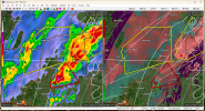
DISCUSSION...The latest WSR-88D radar out of Jackson, Mississippi
and Fort Polk, Louisiana show two lines of strong convection. The
two lines are parallel to each other, both oriented from southwest
to northeast across northeast Louisiana and southeast Arkansas. The
western most line, which is located along and near the instability
axis, has been the most severe. But the line further east has been
gradually intensifying. These storms are located along and near the
axis of an 850 mb jet with winds at between 50 and 60 knots. The
strong low-level flow is contributing to 0-3 km storm relative
helicities of over 500 m2/s2, evident on RAP forecast soundings.
This shear environment will continue to be favorable for supercells
and tornadoes for the remainder of the evening. This threat, along
with a potential for wind damage, should move gradually eastward
toward the Mississippi River over the next few hours.
..Broyles.. 12/14/2022


/cloudfront-us-east-1.images.arcpublishing.com/gray/EVL42VLARFF3LDKEWM3SJONZQE.png)
/cloudfront-us-east-1.images.arcpublishing.com/gray/5E4FR75YSJH5LPRPQPG4FENXCE.png)
/cloudfront-us-east-1.images.arcpublishing.com/gray/AZA26L7WGVHJTIGDEP6OPCHOYQ.png)


