• Welcome to TalkWeather!
    We see you lurking around TalkWeather! Take the extra step and join us today to view attachments, see less ads and maybe even join the discussion.
    CLICK TO JOIN TALKWEATHER

Severe WX Severe Weather Event April 13-14, 2019

Fred Gossage

Member
Meteorologist
PerryW Project Supporter
Messages
596
Reaction score
2,095
Location
Florence, AL
@Fred Gossage what are your thoughts as the show starts in AL?

@Breezy Sorry I wasn't able to answer this last night. I'm not as free as I used to be back in my hay-day here on TalkWeather. I was in live coverage at the time last night for our operation Shoals Weather, where we provide weather information for northwest Alabama, northeast Mississippi, and adjacent Tennessee counties. We provide live streaming tornado coverage, and I wasn't able to keep an eye on the forum.
 

warneagle

Member
Messages
3,729
Reaction score
3,208
Location
Arlington, VA
Special Affiliations
  1. SKYWARN® Volunteer
There's a warning up to my north near Frederick, MD. Nothing on the ground but someone reported a visible wall cloud
 

warneagle

Member
Messages
3,729
Reaction score
3,208
Location
Arlington, VA
Special Affiliations
  1. SKYWARN® Volunteer
Possible TOG moving into Westminster, MD, the CC data is a bit cluttered but it's a strong couplet. (this is nowhere close to me, we haven't even gotten any rain yet)
 

Argus

Member
Messages
297
Reaction score
141
Location
Athens, Georgia
We went outside this evening to watch the line of storms, and got a bonus treat. Lots of airliners were flying over us inbound to Atlanta going around those storms. We posted on the Twitter feed a few pictures. Brit was excited about planespotting in literally our backyard.
 
F

Former Member

Guest
We went outside this evening to watch the line of storms, and got a bonus treat. Lots of airliners were flying over us inbound to Atlanta going around those storms. We posted on the Twitter feed a few pictures. Brit was excited about planespotting in literally our backyard.
If you enjoy planespotting, https://www.flightradar24.com is fun. I have the app on my phone and enjoy sitting out seeing what comes over.
 

WesL

"Bill, I'm talkin' imminent rueage"
Staff member
Administrator
Moderator
Sustaining Member
Messages
3,344
Reaction score
2,614
Location
Fayetteville, AR
Special Affiliations
  1. SKYWARN® Volunteer
Damage from Shelby, OH.
Fox 8 - Cleveland


Drone footage -

 
  • Like
Reactions: KoD

bjdeming

Member
Sustaining Member
Messages
1,512
Reaction score
1,231
Location
Corvallis, Oregon
There are no watches up yet, and I'm probably just being gloomy -- and it's a different meteorological environment -- but I was in upstate New York for the 1998 tornadoes and know that people aren't prepared for such weather. And I really hate to see this ugly squall line, quite large for that region, coming at so many people in the middle of the night under conditions that have spurred this current MD, including:

The severe threat is likely to develop eastward into southeast New York, eastern Pennsylvania and New Jersey over the next few hours. A tornado and wind damage threat will be likely. Weather watch issuance will be needed to the east of the current watches over the next hour or so.

Weather events are much rarer but can happen up there, and few of those millions of sleeping people right now have weather radios, let alone tornado sirens (which can't be heard very well indoors anyway). I hope there's no problem tonight.

PS: I'm trying to attach an image of the radar GIF image that I downloaded and keep getting a message that it's not an image (it is). ???
 

bjdeming

Member
Sustaining Member
Messages
1,512
Reaction score
1,231
Location
Corvallis, Oregon
Right now, no watch [update: watch just went up, one of many in the east]; just potential for severe T-storms later tonight per the Teterboro, NJ, NWS website.

000
FXUS61 KOKX 150356
AFDOKX

Area Forecast Discussion
National Weather Service New York NY
1156 PM EDT Sun Apr 14 2019

.SYNOPSIS...
A cold front approaches tonight and moves through late at night into
Monday morning. High pressure returns Tuesday into Wednesday
and then gradually gives way to a warm front approaching from
the southwest. The warm front lifts north Friday morning,
followed by a cold frontal passage late Saturday into Sunday.

&&

.NEAR TERM /THROUGH MONDAY/...
Quick update to trend temperatures/dew points more towards hi
res data to account for mesoscale details as the warm front
begins to move through the area. Main concern in the overnight
apart from fog will be convection nearing the area. With a
strengthening low-level jet and warm advection, there is
potential for at least a brief window of strengthening as the
line moves into our area, with increasing surface-based
instability allowing potential for damaging wind gusts to reach
the surface. Will need to monitor closely.
 
Last edited:

bjdeming

Member
Sustaining Member
Messages
1,512
Reaction score
1,231
Location
Corvallis, Oregon
Edit: Never mind; canceled per National Weather Service Watch Warning Advisory Summary https://forecast.weather.gov/wwamap/wwatxtget.php?cwa=usa&wwa=Tornado%20Warning

I hope that's all there is tonight! (Lots of wind damage reports on the SPC website from this whole area, and into Virginia and North Carolina -- guess many people aren't slumbering after all.)

Severe Weather Statement
National Weather Service Binghamton NY
118 AM EDT Mon Apr 15 2019

PAC015-115-150530-
/O.CON.KBGM.TO.W.0001.000000T0000Z-190415T0530Z/
Susquehanna PA-Bradford PA-
118 AM EDT Mon Apr 15 2019

...A TORNADO WARNING REMAINS IN EFFECT UNTIL 130 AM EDT FOR
SOUTHWESTERN SUSQUEHANNA AND SOUTHEASTERN BRADFORD COUNTIES...

At 118 AM EDT, a severe squall line capable of producing both
tornadoes and extensive straight line wind damage was located over
Sugar Run, or near Wyalusing, moving northeast at 50 mph.

HAZARD...Tornado.

SOURCE...Radar indicated rotation.

IMPACT...Flying debris will be dangerous to those caught without
shelter. Mobile homes will be damaged or destroyed. Damage
to roofs, windows, and vehicles will occur. Tree damage is
likely.
dit:
These dangerous storms will be near...
Rush around 130 AM EDT.
 
Last edited:

bjdeming

Member
Sustaining Member
Messages
1,512
Reaction score
1,231
Location
Corvallis, Oregon
There's a warning up for parts of east central Virginia, too -- am just focusing on the areas where tornados are not so common, especially overnight ones. Sorry to be posting so much, but guess I should (and the true TW experts here are probably getting some very well-deserved rest in preparation for another work week - thank you for your coverage here to help the rest of us understand and follow these events better)..[Update: They're going to let it expire but maintain the severe T-storm warning; meanwhile, the tornado warning in east central Virginia continues..]

Tornado Warning
NYC007-017-025-150600-
/O.NEW.KBGM.TO.W.0002.190415T0535Z-190415T0600Z/

BULLETIN - EAS ACTIVATION REQUESTED
Tornado Warning
National Weather Service Binghamton NY
135 AM EDT Mon Apr 15 2019

The National Weather Service in Binghamton has issued a

* Tornado Warning for...
Southeastern Broome County in central New York...
West central Delaware County in central New York...
Southeastern Chenango County in central New York...

* Until 200 AM EDT.

* At 134 AM EDT, severe thunderstorms capable of producing both
tornadoes and extensive straight line wind damage were located
along a line extending from near Sanitaria Springs to near
Kirkwood, moving east at 40 mph.

HAZARD...Tornado.

SOURCE...Radar indicated rotation.
 
Last edited:

bjdeming

Member
Sustaining Member
Messages
1,512
Reaction score
1,231
Location
Corvallis, Oregon
The Virginia warning is still on {correction: 2 warnings in VA], and there's another one in south central New York, too.

For those, like me, who have no other sources, most up-to-date information on warnings in all areas are here. Eastern Virginia and extreme southern Maryland are under the gun now.

Tornado Warning
MDC009-017-033-150645-
/O.NEW.KLWX.TO.W.0009.190415T0611Z-190415T0645Z/

BULLETIN - EAS ACTIVATION REQUESTED
Tornado Warning
National Weather Service Baltimore MD/Washington DC
211 AM EDT Mon Apr 15 2019

The National Weather Service in Sterling Virginia has issued a

* Tornado Warning for...
Northwestern Calvert County in southern Maryland...
Southeastern Prince Georges County in central Maryland...
Northeastern Charles County in southern Maryland...

* Until 245 AM EDT.

* At 211 AM EDT, a severe thunderstorm capable of producing a tornado
was located 7 miles northwest of Hallowing Point, moving east at 60
mph.

HAZARD...Tornado.

SOURCE...Radar indicated rotation.

IMPACT...For those in the direct path of a tornado touchdown,
flying debris will be dangerous to those caught without
shelter. Damage to roofs, siding, and windows may occur.
Mobile homes may be damaged or destroyed. Tree damage is
likely.

* This dangerous storm will be near...
Prince Frederick around 220 AM EDT.
Chesapeake Beach around 225 AM EDT.

Other locations impacted by this tornadic thunderstorm include Lower
Marlboro, Eagle Harbor, Aquasco, Huntingtown, Sunderland, Dares
Beach, Owings, Hughesville and Baden.

PRECAUTIONARY/PREPAREDNESS ACTIONS...

TAKE COVER NOW! Move to a basement or an interior room on the lowest
floor of a sturdy building. Avoid windows. If you are outdoors, in a
mobile home, or in a vehicle, move to the closest substantial shelter
and protect yourself from flying debris.

Tornadoes are extremely difficult to see and confirm at night. Do not
wait to see or hear the tornado. TAKE COVER NOW!
 
Last edited:

bjdeming

Member
Sustaining Member
Messages
1,512
Reaction score
1,231
Location
Corvallis, Oregon
Not good. BTW, can't find any mention of damage or confirmation other than radar in online news for any of these warnings; this area is not exactly ideal storm spotting country. Lots of wind damage reports, including fallen trees blocking every road in one Pennsylvania city (Duclose, I think). Also, heavy rains with this system are causing flooding.

Tornado Warning
DEC003-NJC005-007-015-033-PAC045-091-101-150745-
/O.NEW.KPHI.TO.W.0002.190415T0719Z-190415T0745Z/

BULLETIN - EAS ACTIVATION REQUESTED
Tornado Warning
National Weather Service Mount Holly NJ
319 AM EDT MON APR 15 2019

The National Weather Service in Mount Holly NJ has issued a

* Tornado Warning for...
Northeastern New Castle County in northern Delaware...
North central Salem County in southern New Jersey...
Northwestern Camden County in southern New Jersey...
Northwestern Gloucester County in southern New Jersey...
Northwestern Burlington County in southern New Jersey...
Southeastern Montgomery County in southeastern Pennsylvania...
Philadelphia County in southeastern Pennsylvania...
Delaware County in southeastern Pennsylvania...

* Until 345 AM EDT.

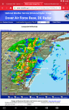
* At 318 AM EDT, a severe thunderstorm capable of producing a tornado
was located near Chester Township, or 8 miles northeast of
Wilmington, moving northeast at 55 mph.

HAZARD...Tornado.

SOURCE...Radar indicated rotation.

IMPACT...Flying debris will be dangerous to those caught without
shelter. Mobile homes will be damaged or destroyed.
Damage to roofs, windows, and vehicles will occur. Tree
damage is likely.

* Locations impacted include...
Philadelphia, Camden, Wilmington, Gloucester City, Cherry Hill,
Chester, Deptford, West Deptford, Bellmawr, Yeadon, Woodbury,
Carneys Point, Palmyra, Folcroft, Swarthmore, Paulsboro, Penns
Grove, Jenkintown, Magnolia and Westville.

PRECAUTIONARY/PREPAREDNESS ACTIONS...

TAKE COVER NOW! Move to a basement or an interior room on the lowest
floor of a sturdy building. Avoid windows. If you are outdoors, in a
mobile home, or in a vehicle, move to the closest substantial shelter
and protect yourself from flying debris.

Heavy rainfall may hide this tornado. Do not wait to see or hear the
tornado. TAKE COVER NOW!

Tornadoes are extremely difficult to see and confirm at night. Do not
wait to see or hear the tornado. TAKE COVER NOW!

To report severe weather contact your nearest law enforcement agency.
They will send your report to the National Weather Service office in
Mount Holly NJ.

&&

LAT...LON 3966 7541 3983 7556 4015 7514 3990 7491
TIME...MOT...LOC 0718Z 234DEG 48KT 3981 7541

TORNADO...RADAR INDICATED
HAIL...<.75IN

$$

MPS
 

bjdeming

Member
Sustaining Member
Messages
1,512
Reaction score
1,231
Location
Corvallis, Oregon
Not sure if this is correct, but it looks like the line of storms is dying out in the more stable air by the coast. Still finding no news reports of tornados -- don't know which TV stations to check in that area -- but a lot of people there are going to have a very difficult morning commute today. . . so glad it wasn't worse. Good night. :)
 

akt1985

Member
Messages
1,009
Reaction score
508
Location
Madison, Alabama
The squall line just went through Boston. At least now there won’t be any concerns with severe weather happening during the Boston Marathon today.
 

Equus

Member
Messages
3,290
Reaction score
3,368
Location
Jasper, AL
Special Affiliations
  1. SKYWARN® Volunteer
So. I'm gonna have to be 'that guy' and highly disagree with the Hamilton tornado rating. To get a 130mph EF2 from the house with only a single small interior room standing, poorly built or not, requires turning the EF scale DI slider to literally the very bottom end, which WFOs are seemingly defaulting to now. BMX rated a home with similar degree of exterior walls standing (albeit with much stronger contextual evidence and brick construction) EF4 at Beauregard.
 
Logo 468x120
Back
Top