- Moderator
- #761
We dodged a bullet here in NW Alabama. That monster storm was headed right up this way.
Follow along with the video below to see how to install our site as a web app on your home screen.
Note: This feature may not be available in some browsers.
Are we in the clear?We dodged a bullet here in NW Alabama. That monster storm was headed right up this way.
Are we in the clear?
Glad to hear it is sparsely populated. Even more glad to hear you are okay.'s
That's 30 miles north of me and a sparsely populated area....
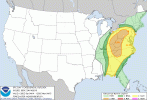
Day 1 is out and I did not see it posted here yet. , As a complete newbie who lives in Georgia right below Atlanta, how much confidence is there in this panning out to being a 'less severe' threat as they are predicting, as they just dropped my area from the enhanced risk to slight risk? I hope all of you are staying safe this evening.