• Welcome to TalkWeather!
    We see you lurking around TalkWeather! Take the extra step and join us today to view attachments, see less ads and maybe even join the discussion.
    CLICK TO JOIN TALKWEATHER

Severe WX Severe Weather Event April 13-14, 2019

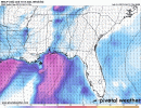
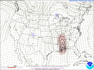
Last few times we had a high end setup in this part of the country (north LA) we got MORE convection than was expected that choked things off. Is this a possibility here? Is that part of the uncertainty with this setup?

I'd say it's very possible in western portions of the risk area.

I would not be surprised AT ALL if E TX and W LA Forecasted Convective Amplification Deficiency but we get a major event along and E of the MS River. Matter of fact, I think that may be the most likely outcome.. messy convection in LA before it gets organized into a handful of dominant supercells in MS.
 
After digging in the 12z nam a little more, I really think there is a chance of the cells moving in to west Alabama will start to crawl or even stall in the 5-7am timeframe. If you look closely, pressures actually drop behind it...unlike your typical prefrontal trough when pressures tend to rise and recoup before the frontal wind shift.
 

Attachments

  • floop-nam-2019041212.sfcwind_mslp.us_se.gif
    floop-nam-2019041212.sfcwind_mslp.us_se.gif
    656.9 KB · Views: 0
After digging in the 12z nam a little more, I really think there is a chance of the cells moving in to west Alabama will start to crawl or even stall in the 5-7am timeframe. If you look closely, pressures actually drop behind it...unlike your typical prefrontal trough when pressures tend to rise and recoup before the frontal wind shift.
That would completely change the game for areas east of there right? I'm in West GA 30 min north of ATL and we have a forecast high of 77 Sunday.
 
FFC put out a video briefing this afternoon for the event in GA on Sunday. They are "downplaying the tornado threat" with a bunch of caveats.


I sure hope that’s the case. Glenn burns was saying the last couple runs of the Euro showed convection on the coast robbing us of energy.
 
I sure hope that’s the case. Glenn burns was saying the last couple runs of the Euro showed convection on the coast robbing us of energy.
I don't have access to Euro precip data. I would be more inclined to agree if some big MCS was down near the gulf. To me it looks like the line extends south to the gulf, but the other models don't show a larger cluster down south. Time will tell..... I did note however an apparent drop in CAPE for North GA on the last NAM run, so that could possibly be a result of less transport from down south.
 
I have a question for you guys in here that are much smarter than me when it comes to weather: Can there be TOO MUCH shear when there is moderate instability that could tear things apart?
 
  • Like
Reactions: KoD
I don't have access to Euro precip data. I would be more inclined to agree if some big MCS was down near the gulf. To me it looks like the line extends south to the gulf, but the other models don't show a larger cluster down south. Time will tell..... I did note however an apparent drop in CAPE for North GA on the last NAM run, so that could possibly be a result of less transport from down south.

The 3km NAM kinda hinted at coastal storms being possible, but it's the only model showing this and is not exactly known for its accuracy.. it's a possibility, but I don't know if it's a high one at least right now.
 
I have a question for you guys in here that are much smarter than me when it comes to weather: Can there be TOO MUCH shear when there is moderate instability that could tear things apart?

It certainly is possible. The answer to this question lies in storm relative flow, and how the vertical wind shear within a given layer relates to storm motion. You may have extreme wind shear, however, if the majority of said shear lies within the storm motion layer (density weighted mean wind), with much lighter shear above that layer, then there typically aren't major issues. I remember back in March when 75 knot upper level storm relative winds were ripping storms apart in eastern New Mexico in an area that was originally expected to get an abundance of strong tornadoes.

Basically, it all comes down to the layer in which the powerful shear is found in relation to the layer which determines storm motion. I'm learning more and more that ratios of varying wind layers in the troposphere are an excellent way to help predict severe convective potential. I'm currently working on something called a "stepped-ratio wind analysis" that could help identify these environments. At least that is how I understand it.
 
Last edited:
3k NAM is putting a nail in the coffin of the threat for AL tomorrow night into Sunday.
Some day we may be able to confidently say that, based on a single computer model. Today is not that day...that's why there are a "boat load" of models and it's an art & science of looking at them all and trying to spot consistencies over time. Even when there is consistency, sometimes mother nature throws us a curve ball. Isn't weather great !!!!! Good news is....we won't have to wait long now to find out what is in store.
 
Right now, it looks like the only thing standing between us and an outbreak tomorrow is the possibility of too many storms firing in the warm sector and the storm mode getting messy--am I missing something else?
 
Back
Top