
Navigation
Install the app
How to install the app on iOS
Follow along with the video below to see how to install our site as a web app on your home screen.
Note: This feature may not be available in some browsers.
More options
-
Welcome to TalkWeather! We see you lurking around TalkWeather! Take the extra step and join us today to view attachments, see less ads and maybe even join the discussion. CLICK TO JOIN TALKWEATHER
You are using an out of date browser. It may not display this or other websites correctly.
You should upgrade or use an alternative browser.
You should upgrade or use an alternative browser.
Severe Weather 2024
- Thread starter KevinH
- Start date
Pretty robust look as well. A bigger warm sector but looks a tad pinched.GFS still signalling activity 1/12-1/13.
I've been holding off looking at it but it is next in the pipeline. After this significant event.
CheeselandSkies
Member
Instability seems to be ticking up a bit, and over a larger area of MS/AL on recent GFS runs with the Friday system, especially tonight's 00Z. For some reason, hodographs/SRH are consistently not as impressive on forecast soundings as with the early week system, despite the 500mb trough and surface low being just as if not more intense. Still ample SRH for a tornado threat, though. This is near Birmingham:

- Thread starter
- #204
KevinH
Member
SPC has highlighted risk areas of severe LATER this week January 11th-12th.
A new thread has been created.
A new thread has been created.
- Thread starter
- #206
tornado examiner
Member
Tornado in Florida on a general thunderstorm day

- Moderator
- #209
Fairly impressive supercell south of Pt. St. Lucie now.
View attachment 23435
My ex lives in Port Saint Lucie. And that's all I'm going to say about that...
- Thread starter
- #210
KevinH
Member
Accurate lolGFS still signalling activity 1/12-1/13.
- Thread starter
- #211
KevinH
Member
My ex lives in Port Saint Lucie. And that's all I'm going to say about that...
 lol
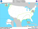
lolIn other news, watch for a potential heavy rain/severe weather risk across the Deep South (Dixie Alley) around the 24/25th of the month. Just a gut feeling plus this map. I admit. I enjoy forecasting severe weather/heavy rain threats more than snow threats. Much easier. LOL!
Attachments
I knew you would be the first to like this @KevinH! LOL!
- Thread starter
- #214
TH2002
Member
- Messages
- 4,974
- Reaction score
- 11,116
- Location
- California, United States
- Special Affiliations
- SKYWARN® Volunteer
Someone: I like calm weatherIn other news, watch for a potential heavy rain/severe weather risk across the Deep South (Dixie Alley) around the 24/25th of the month. Just a gut feeling plus this map. I admit. I enjoy forecasting severe weather/heavy rain threats more than snow threats. Much easier. LOL!
Dixie: Oh, I'm sorry, did you say you want some Severe Weather?
Someone: NO, I SAID-
Dixie: Okay. Here's some Severe Weather.
Someone: "Oh sh-"
EXACTLY!!!!!Someone: I like calm weather
Dixie: Oh, I'm sorry, did you say you want some Severe Weather?
Someone: NO, I SAID-
Dixie: Okay. Here's some Severe Weather.
Someone: "Oh sh-"
- Thread starter
- #217
KevinH
Member
BasicallySomeone: I like calm weather
Dixie: Oh, I'm sorry, did you say you want some Severe Weather?
Someone: NO, I SAID-
Dixie: Okay. Here's some Severe Weather.
Someone: "Oh sh-"
- Moderator
- #218
I would rather dodge tornadoes in the hills of North Alabama than deal with this mess again. At least if it's warm enough for severe I can get out of my house!
Gail
Member
In other news, watch for a potential heavy rain/severe weather risk across the Deep South (Dixie Alley) around the 24/25th of the month. Just a gut feeling plus this map. I admit. I enjoy forecasting severe weather/heavy rain threats more than snow threats. Much easier. LOL!
Hopefully we are able to get our shelter by then! I’m not sure how long it takes once they start.
I’ll take snow anyday, but I’m not a fan of the ice chances. At least with severe weather, it’s here and there and not everywhere like the sleet/ice. I’m just glad it seems like the power lines held up well in this so far!
SPC Day 4-8 Discussion:
"The beginning of the period will see an upper trough over the
eastern states and an upper ridge over the West. The upper ridge
will weaken as it slides east over the Plains on Day 5/Sat, with a
lower-amplitude pattern emerging east of the Rockies through Day
6/Sun. During the latter half of the period, an upper trough is
forecast to develop over the western U.S. Strong surface high
pressure over the Plains on Day 4/Fri will shift east through the
period, and another frontal intrusion into the Gulf of Mexico will
result in a generally dry/stable airmass for much of the Day 4-8
period. As the western upper trough develops late in the period,
surface lee troughing will promote southerly low-level flow over the
southern Plains and some Gulf moisture return is expected. As this
occurs, thunderstorm potential may increase across parts of the
southern Plains around Days 7-8/Mon-Tue. Modest deep-layer flow over
the region, and the upper trough remaining well west, will likely
limit severe potential until perhaps just beyond Day 8/Tue."