
Navigation
Install the app
How to install the app on iOS
Follow along with the video below to see how to install our site as a web app on your home screen.
Note: This feature may not be available in some browsers.
More options
-
Welcome to TalkWeather! We see you lurking around TalkWeather! Take the extra step and join us today to view attachments, see less ads and maybe even join the discussion. CLICK TO JOIN TALKWEATHER
You are using an out of date browser. It may not display this or other websites correctly.
You should upgrade or use an alternative browser.
You should upgrade or use an alternative browser.
Severe Weather 2024
- Thread starter KevinH
- Start date
Casuarina Head
Member
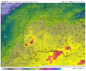
For the record: an 8-mi-long EF0 tornado was confirmed in association with this cell. Results of the official survey:Fairly impressive supercell south of Pt. St. Lucie now.
View attachment 23435
A National Weather Service Melbourne damage survey confirms that
an EF-0 tornado impacted the communities of Palm City and Stuart
on Monday, January 15, 2024.
The tornado touched down to the south and west of I-95 before
crossing the interstate around 4:43 PM EST. The system moved to
the north-northeast into Palm City, where numerous trees were
felled on properties between I-95 and SW Martin Hwy. The
circulation continued to the northeast in Stuart where numerous
residents submitted videos of the tornado impacting portions of
the Canopy Creek residential subdivision, though little in the way
of damage was noted. Additional intermittent reports of downed
trees were reported along the path as it moved across Florida's
Turnpike and into Stuart.
The circulation eventually went on to produce a waterspout over
the St. Lucie River that then pushed onshore and into the North
River Shores subdivision before lifting and dissipating. The
tornado produced minor damage here, including a few fallen trees
near the intersection of NW Pine Lake Dr and NW Fork Rd.
There are no known direct injuries or fatalities as a result of
the wind damage. Thank you to Martin County Emergency Management
and Fire Rescue officials, as well as local broadcast media,
trained spotters, as well as local residents for providing
information before and during the storm survey.
- Moderator
- #223
Day 4-8 Convective Outlook
NWS Storm Prediction Center Norman OK
0313 AM CST Thu Jan 18 2024
Valid 211200Z - 261200Z
...DISCUSSION...
An upper-level trough over the western U.S. early in the period will
slowly shift east toward the Rockies and adjacent High Plains
through at least Day 6/Tue. Beyond Tuesday, most medium-range
guidance depicts a mean upper trough roughly over the High Plains,
with a series of shortwave ejecting east/northeast into the
Mid-South/Midwest vicinity Days 7-8/Wed-Thu. This overall pattern
will support long-duration deep-layer southwesterly flow across the
southern Plains, Lower MS Valley/Gulf coast states and the
Mid-South. As a result, Gulf moisture is expected to return
northward, first across the Texas coastal vicinity on Day 4/Sun
before also increasing across much of the rest of the Gulf coast
states the remainder of the period.
Given increased southwesterly flow overspreading returning Gulf
moisture, at least some low-end severe potential appears possible
across coastal TX early in the period. Some severe potential could
then shift east across the Gulf Coast states later in the period,
(around Day 7 or 8/Wed or Thu) when some guidance shows a stronger
shortwave trough ejecting over the Lower MS/TN Valley vicinity in
conjunction with a deeper surface low and cold front.
Severe potential appears too low early in the period to include 15
percent probabilities. Uncertainty in timing and latitudinal
position of the possible late-period shortwave trough also precludes
probabilities at this time. Nevertheless, this pattern change could
support increasing severe potential with time across Gulf coast
areas, which may necessitate probabilities in the coming days.

tennessee storm chaser
Member
- Messages
- 1,877
- Reaction score
- 4,288
- Location
- jackson tennessee
- Special Affiliations
- SKYWARN® Volunteer
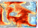
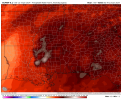
It’s going take little time for the atmosphere to recover . This artic air has done a number on it … not to sold on this idea just yetCIPS extended-range analogs show an elevated signal for convective potential near the end of medium-range.
View attachment 23511
It will take a while, but if the GFS is right, something could be up by next weekend.It’s going take little time for the atmosphere to recover . This artic air has done a number on it … not to sold on this idea just yet


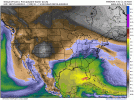
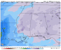
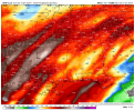
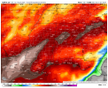
Impressive for mid/late JanuaryGFS and ECMWF show a bountiful supply of moisture for a rather protracted period during the next week. Folks in flood-prone areas definitely ought to keep a close eye out, at least.
View attachment 23516View attachment 23517
- Moderator
- #229
It’s going take little time for the atmosphere to recover . This artic air has done a number on it … not to sold on this idea just yet
It will take a while, but if the GFS is right, something could be up by next weekend.
Not just the GFS. Multiple models with a good inland push of upper 60 to low 70 dew points.
GFS has a lot of little disturbances that come up through the gulf and give Dixie alley a shot at being in the warm sector coming up next week
One thing you can nearly guarantee is that there's gonna be a heavy rain/flash flood threat. NWS Jackson mentioned this as a concern in their morning outlook. At this juncture, the severe weather risk would likely be confined to the Gulf Coast. But being honest, it is the Gulf we are talking and it doesn't take much to get warmer/moist dewpoints further north. Plus you might have moisture from the Pacific getting involved as well.
TH2002
Member
- Messages
- 4,974
- Reaction score
- 11,116
- Location
- California, United States
- Special Affiliations
- SKYWARN® Volunteer
)
HILARIOUS!!!!!! But honestly true especially the last one unfortunately
TH2002
Member
- Messages
- 4,974
- Reaction score
- 11,116
- Location
- California, United States
- Special Affiliations
- SKYWARN® Volunteer
I'll never understand the mindset of people like that, hence why I made fun of it. Those who think crappy reality shows are more important than life-saving severe weather coverage could certainly use a reality check, to put it lightly.HILARIOUS!!!!!! But honestly true especially the last one unfortunately
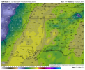
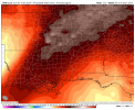
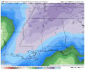
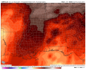
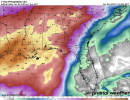
12z Euro,12z Canadian, and 18z GFS PWAT/Precipitation Anomalies for within the 24th thru 28th timeframe.
Attachments
-
 gem-all-alms-pwat-6205600.png143.1 KB · Views: 0
 -
 gfs-deterministic-alms-pwat-6400000.png141.5 KB · Views: 0
 -
 gfs-deterministic-alms-pwat_norm_anom-6400000.png132.8 KB · Views: 0
 -
 gfs-deterministic-alms-pwat_anom-6400000.png121.1 KB · Views: 0
 -
 gem-all-alms-pwat_norm_anom-6205600.png132.8 KB · Views: 0
 -
 gem-all-alms-pwat_anom-6205600.png119.3 KB · Views: 0
 -
 ecmwf-deterministic-alms-pwat-6140800.png138 KB · Views: 0
 -
 ecmwf-deterministic-alms-pwat_norm_anom-6140800.png135.4 KB · Views: 0
 -
 ecmwf-deterministic-alms-pwat_anom-6140800.png118.8 KB · Views: 0
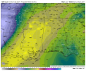
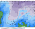
Updated 7 day precip totals from WPC and total precip thru 180 hours off the 18z GFS, 12z Euro, 12z Canadian.
Attachments

Wednesday looks to be active.


- Moderator
- #239
Models look mixed on when the best day of severe weather will come next week.
for now this has a look of the cold front rushing and catching up and cutting off the storms aheadSaturday-ish (1/27ish) showing signs for activity on the last few runs of the GFS, in addition to Wednesday.
View attachment 23573View attachment 23574View attachment 23575