
Somebody is going to absolutely get flooded next week and my best bet is a long the Mississippi river. There maybe enough shear and instability for a severe/tornado event. But it's not going to be the best setup ever lol
Navigation
Install the app
How to install the app on iOS
Follow along with the video below to see how to install our site as a web app on your home screen.
Note: This feature may not be available in some browsers.
More options
-
Welcome to TalkWeather! We see you lurking around TalkWeather! Take the extra step and join us today to view attachments, see less ads and maybe even join the discussion. CLICK TO JOIN TALKWEATHER
You are using an out of date browser. It may not display this or other websites correctly.
You should upgrade or use an alternative browser.
You should upgrade or use an alternative browser.
Severe Weather 2024
- Thread starter KevinH
- Start date
Jackson MS, morning discussion.

wx_guy
Member
- Messages
- 1,237
- Reaction score
- 4,443
- Location
- United States
- HAM Callsign
- KO4ZGH
- Special Affiliations
- SKYWARN® Volunteer
- ARRL Member
A GFS forecast sounding for NOLA for Wednesday. Temperatures of almost 80 degrees, surface CAPE of nearly 3000, strong Theta-E change with height, lapse rates of almost 7...seems ripe for some severe weather in the Louisiana/Missisippi Gulf Coast region. Not the best hodographs, but there is pretty good curvature in the 0-3 km (red) range.

Seems like surface based convection is limited to the coastal region like the sounding you showed, probably will change as we get closer. But I was checking soundings and as soon as you get into southern Mississippi past Louisiana; convection goes elevated in a hurry. Would further limit tornado potential to just coastal areas I'm not sure why exactly it's doing that I don't understand a whole lot when it comes to why some environments are more elevated than surface based even with adequate moisture. Maybe some more knowledge guys can explainA GFS forecast sounding for NOLA for Wednesday. Temperatures of almost 80 degrees, surface CAPE of nearly 3000, strong Theta-E change with height, lapse rates of almost 7...seems ripe for some severe weather in the Louisiana/Missisippi Gulf Coast region. Not the best hodographs, but there is pretty good curvature in the 0-3 km (red) range.
View attachment 23579
wx_guy
Member
- Messages
- 1,237
- Reaction score
- 4,443
- Location
- United States
- HAM Callsign
- KO4ZGH
- Special Affiliations
- SKYWARN® Volunteer
- ARRL Member
Yeah, even with that sounding, I'm not convinced that either setup (Wednesday or Saturday) this coming week presents itself as any sort of outbreak. At the moment, it feels more likely to be flooding threats in isolated areas all week long than explosive severe weather. But I guess we'll see.Seems like surface based convection is limited to the coastal region like the sounding you showed, probably will change as we get closer. But I was checking soundings and as soon as you get into southern Mississippi past Louisiana; convection goes elevated in a hurry. Would further limit tornado potential to just coastal areas I'm not sure why exactly it's doing that I don't understand a whole lot when it comes to why some environments are more elevated than surface based even with adequate moisture. Maybe some more knowledge guys can explain
wx_guy
Member
- Messages
- 1,237
- Reaction score
- 4,443
- Location
- United States
- HAM Callsign
- KO4ZGH
- Special Affiliations
- SKYWARN® Volunteer
- ARRL Member
The SPC in their Day 4-8 outlook today also paints the severe weather this next week in a very iffy light:
...DISCUSSION...
...Tuesday/Day 4 to Thursday/Day 6...
Southwest flow at mid-levels is forecast to shift from the Great
Plains and Mississippi Valley on Tuesday to the Ohio and Tennessee
Valleys by Thursday, as an upper-level trough remains in the
vicinity of the Four Corners and southern Rockies. Ahead of the
trough on Tuesday, a moist airmass is expected to be in place over
the Texas Coastal Plain and lower Mississippi Valley. The moist
airmass is forecast to move eastward across the Gulf Coast states on
Wednesday and Thursday. Scattered thunderstorms will likely develop
over parts of the moist sector each day. However, instability is
forecast to be weak, suggesting that any severe threat will be
isolated and marginal.
...Friday/Day 7 and Saturday/Day 8...
On Friday, the moist airmass is forecast to shift eastward to the
southern Atlantic Seaboard, where isolated to scattered
thunderstorms will be possible on Friday and Saturday. Instability
is expected to be very weak suggesting convection will remain
unorganized Friday into Saturday.
- Moderator
- #247
The big area of 500-2000 sb cape on the GFS runs is not very weak.
Last edited:
That's what I was thinking haha. I was thinking maybe there seeing something I'm not.The big area of 500-2000 sb cape on the GFS runs is not very weak.
tennessee storm chaser
Member
- Messages
- 1,877
- Reaction score
- 4,288
- Location
- jackson tennessee
- Special Affiliations
- SKYWARN® Volunteer
GFS is an outlier at the moment....The big area of 500-2000 sb cape on the GFS runs is not very weak.
Time to bring out a golden oldie...


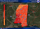
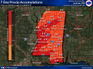
To be honest, next week's pattern and heavy rain event reminds me of what we dealt with in January and February 2020.
Ended January 2020 with 10.25 inches
Ended February 2020 with 15.10 inches
Ended January 2020 with 10.25 inches
Ended February 2020 with 15.10 inches
wx_guy
Member
- Messages
- 1,237
- Reaction score
- 4,443
- Location
- United States
- HAM Callsign
- KO4ZGH
- Special Affiliations
- SKYWARN® Volunteer
- ARRL Member
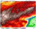
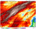
Yeah, here's the NWS National Blend of Models forecast for the next 10 days rainfall. Louisiana, Mississippi, and Alabama look to be socked with lots of rain. A couple of the models (mainly the GFS) still wants to put severe weather in the extreme southerly Coastal regions of Louisiana/Mississippi Wednesday and over the Big Bend and Georgia next Saturday...but I agree with Clancy that lots of rain with occasional isolated embedded strong-to-severe thunderstorms and maybe a one-off tornado is the call. I suspect the SPC to have a lot of Marginal risk areas this week but not much else.

Having enjoyed our free trial of Alaskan weather, we are now scheduled for a free trial of an Indian monsoon.
I don't recall signing up for either.Having enjoyed our free trial of Alaskan weather, we are now scheduled for a free trial of an Indian monsoon.
As long the road don't get wash out again like 2020, I be happyTo be honest, next week's pattern and heavy rain event reminds me of what we dealt with in January and February 2020.
Ended January 2020 with 10.25 inches
Ended February 2020 with 15.10 inches
Got me a new thermometer setup outside under my front deck. A balmy 24 degrees here lol. 