
Looks like gulf convection maybe the reason the instability is stunted to the gulf for Wednesday. I like the kinematics though for a severe/tornado risk. Worth watching if this gulf convection doesn't materialize.
Navigation
Install the app
How to install the app on iOS
Follow along with the video below to see how to install our site as a web app on your home screen.
Note: This feature may not be available in some browsers.
More options
-
Welcome to TalkWeather! We see you lurking around TalkWeather! Take the extra step and join us today to view attachments, see less ads and maybe even join the discussion. CLICK TO JOIN TALKWEATHER
You are using an out of date browser. It may not display this or other websites correctly.
You should upgrade or use an alternative browser.
You should upgrade or use an alternative browser.
Severe Weather 2024
- Thread starter KevinH
- Start date
Austin Dawg
Member
We may have been down to 23 degrees with gusty north winds last night but we are supposed to be moving toward 60 degrees with a rare heavy rain event late tomorrow night thru most of the week.
- Moderator
- #263
Time to bring out a golden oldie...
View attachment 23582
Is that the dude that yells "John!"
IT IS!!!! LOL!Is that the dude that yells "John!"
wx_guy
Member
- Messages
- 1,237
- Reaction score
- 4,443
- Location
- United States
- HAM Callsign
- KO4ZGH
- Special Affiliations
- SKYWARN® Volunteer
- ARRL Member
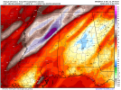
Here's the MMFS (from Andrew Brady, the Developer of StormNet) STP forecasted values at 15z Wednesday and 0z Wednesday night, using Deep Learning AI. It obviously expects some level of severe threat for Louisiana and Mississippi.


wx_guy
Member
- Messages
- 1,237
- Reaction score
- 4,443
- Location
- United States
- HAM Callsign
- KO4ZGH
- Special Affiliations
- SKYWARN® Volunteer
- ARRL Member
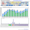
Meh, looks like even if the STP may be elevated, there may not be enough energy/instability. The HazCast (also by Andrew Brady) gives between a 2-5% chance for the Louisiana/Mississippi area on Wednesday for tornado within 25 miles. I snapshotted the 21z below. So still looking a low-end threat, at least for tornadoes.

wx_guy
Member
- Messages
- 1,237
- Reaction score
- 4,443
- Location
- United States
- HAM Callsign
- KO4ZGH
- Special Affiliations
- SKYWARN® Volunteer
- ARRL Member
And the HazCast at 18z Wednesday for severe wind, also a low-end threat:

If that verified that would be a slight risk, about what I thought would happen for this event. With a enchanched as a low possibility.Meh, looks like even if the STP may be elevated, there may not be enough energy/instability. The HazCast (also by Andrew Brady) gives between a 2-5% chance for the Louisiana/Mississippi area on Wednesday for tornado within 25 miles. I snapshotted the 21z below. So still looking a low-end threat, at least for tornadoes.
View attachment 23596
I'm waiting to see what some of the mesoscale models show, a few questions on the atmosphere to be had and I don't think the global models will help in figuring it out lol
Saturday gives me some sneaky event thoughts though, albeit the theta e doesn't look to impressive so I don't expect instability to be anything above meager... But if that changes I know what I'll be doing Saturday lol.
@Clancy ready for a deeping low to shunt any storms south of your area again haha. I'm seriously suspicious on Saturday a few tweaks in one direction and ...
Just look at the 500mb for Saturday!
*Realized the GFS is the only one that shows this the euro doesn't lol

@Clancy ready for a deeping low to shunt any storms south of your area again haha. I'm seriously suspicious on Saturday a few tweaks in one direction and ...
Just look at the 500mb for Saturday!
*Realized the GFS is the only one that shows this the euro doesn't lol
Last edited:
tennessee storm chaser
Member
- Messages
- 1,877
- Reaction score
- 4,288
- Location
- jackson tennessee
- Special Affiliations
- SKYWARN® Volunteer
Think our next legit area wide severe threat comes first week February , when mjo goes through phases 4 and 5…. Pna goes slightly negative
euro is showing a similar solution for Saturday like the GFS was
- Moderator
- #273
Day 4-8 Convective Outlook
NWS Storm Prediction Center Norman OK
0355 AM CST Sun Jan 21 2024
Valid 241200Z - 291200Z
...DISCUSSION...
...Wednesday/Day 4 to Friday/Day 6...
On Wednesday and Thursday, an upper-level trough is forecast to move
from northern Mexico to the mid Mississippi Valley, becoming
considerably less amplified with time. At the surface, a cold front
is forecast to move eastward across the Gulf Coast states. Ahead of
the front on Wednesday, a moist airmass is forecast to be in place
with scattered thunderstorms developing across much of the region.
As the front progresses eastward Wednesday night and Thursday, model
forecasts suggest that a line could gradually organize in the
central Gulf Coast states. An isolated severe threat would be
possible as cell coverage and low-level moisture gradually increase,
but the greatest threat will probably be confined to areas near the
Gulf Coast where instability is forecast to be the strongest. At
this time, model forecast parameters suggest any severe threat will
remain localized at best.
On Friday, southwest flow at mid-levels is forecast across the
Southeast, as an upper-level trough moves toward the southern
Plains. Ahead of this trough, thunderstorms will again be possible
Friday afternoon along the Gulf Coast, with the possibility of a
localized severe threat over parts of the Florida Panhandle.
However, differences in model solutions suggest uncertainty is
substantial.
...Saturday/Day 7 and Sunday/Day 8...
On Saturday and Sunday, a strong mid-level jet is forecast to move
northeastward from the southern Plains to the Eastern Seaboard.
Ahead of this feature, a moist airmass is forecast to be in place in
the central Gulf Coast states. Thunderstorm development will be
possible ahead of the jet within the moist airmass. However,
instability is forecast to remain relatively weak across the region
suggesting that any potential severe threat will remain relatively
confined. Uncertainty is substantial concerning the magnitude of any
severe threat on Saturday, mainly due to model differences regarding
the timing of the upper-level trough and the strength of moisture
return. The potential for thunderstorms is expected to decrease on
Sunday as a large area of surface high pressure moves into the
central and eastern U.S.
"Uncertainty is substantial concerning magnitude of any severe threat Saturday" lolDay 4-8 Convective Outlook
NWS Storm Prediction Center Norman OK
0355 AM CST Sun Jan 21 2024
Valid 241200Z - 291200Z
...DISCUSSION...
...Wednesday/Day 4 to Friday/Day 6...
On Wednesday and Thursday, an upper-level trough is forecast to move
from northern Mexico to the mid Mississippi Valley, becoming
considerably less amplified with time. At the surface, a cold front
is forecast to move eastward across the Gulf Coast states. Ahead of
the front on Wednesday, a moist airmass is forecast to be in place
with scattered thunderstorms developing across much of the region.
As the front progresses eastward Wednesday night and Thursday, model
forecasts suggest that a line could gradually organize in the
central Gulf Coast states. An isolated severe threat would be
possible as cell coverage and low-level moisture gradually increase,
but the greatest threat will probably be confined to areas near the
Gulf Coast where instability is forecast to be the strongest. At
this time, model forecast parameters suggest any severe threat will
remain localized at best.
On Friday, southwest flow at mid-levels is forecast across the
Southeast, as an upper-level trough moves toward the southern
Plains. Ahead of this trough, thunderstorms will again be possible
Friday afternoon along the Gulf Coast, with the possibility of a
localized severe threat over parts of the Florida Panhandle.
However, differences in model solutions suggest uncertainty is
substantial.
...Saturday/Day 7 and Sunday/Day 8...
On Saturday and Sunday, a strong mid-level jet is forecast to move
northeastward from the southern Plains to the Eastern Seaboard.
Ahead of this feature, a moist airmass is forecast to be in place in
the central Gulf Coast states. Thunderstorm development will be
possible ahead of the jet within the moist airmass. However,
instability is forecast to remain relatively weak across the region
suggesting that any potential severe threat will remain relatively
confined. Uncertainty is substantial concerning the magnitude of any
severe threat on Saturday, mainly due to model differences regarding
the timing of the upper-level trough and the strength of moisture
return. The potential for thunderstorms is expected to decrease on
Sunday as a large area of surface high pressure moves into the
central and eastern U.S.


wx_guy
Member
- Messages
- 1,237
- Reaction score
- 4,443
- Location
- United States
- HAM Callsign
- KO4ZGH
- Special Affiliations
- SKYWARN® Volunteer
- ARRL Member
Wednesday's possible situation is coming into focus on the NAM now finally. Here's the F084 sounding from New Orleans:

Really messy hodo, but some low-level curvature. Storm Slinky shows storms are relatively vertical. Theta-E profile shows a steep decrease in temperature in the lowest 200 mb of the atmosphere, which shows potential energy is high there. Storm Relative Winds are not very high, though, so HP supercells if any forms are likely. Very modest Supercell, STP, and SHIP parameters, but noteworthy.
The SARS analogue for this event (the only one that shows up, the "WEAK" tornado cell from October 9, 2003 at 23z, is shown in its sounding below:

This sounding honestly isn't a super good match, I don't believe (Critical Angle is very different, Storm Slinky/Theta-E are very different, etc.), so take with a grain of salt.
Setup generally looks favorable for weak rain-wrapped spin-ups, so we'll see. The next 24 hours will give a lot more info.
Really messy hodo, but some low-level curvature. Storm Slinky shows storms are relatively vertical. Theta-E profile shows a steep decrease in temperature in the lowest 200 mb of the atmosphere, which shows potential energy is high there. Storm Relative Winds are not very high, though, so HP supercells if any forms are likely. Very modest Supercell, STP, and SHIP parameters, but noteworthy.
The SARS analogue for this event (the only one that shows up, the "WEAK" tornado cell from October 9, 2003 at 23z, is shown in its sounding below:
This sounding honestly isn't a super good match, I don't believe (Critical Angle is very different, Storm Slinky/Theta-E are very different, etc.), so take with a grain of salt.
Setup generally looks favorable for weak rain-wrapped spin-ups, so we'll see. The next 24 hours will give a lot more info.
atrainguy
Member
cheestaysfly
Member
I'm supposed to drive from NW Alabama to St.Louis this Thursday. Do y'all think weather conditions are looking okay for traveling around then? I know it's a little early to tell for sure, but I don't know if I should be prepared for leftover snow and ice or storms. Typically I go a sort of back way that leads me through Savannah, TN, up to Dyersburg and then Jackson and on into Missouri.
wx_guy
Member
- Messages
- 1,237
- Reaction score
- 4,443
- Location
- United States
- HAM Callsign
- KO4ZGH
- Special Affiliations
- SKYWARN® Volunteer
- ARRL Member
So the SREF is in range now, and it also is not sold on any severe threat Wednesday. This ensemble sounding is from New Orleans at 18z on Wednesday afternoon.

The mean of the ensembles surface CAPE is only 564, STP is low, and just overall not a very conducive setup. Another view of the SREF, showing the probability of STP of 1 or more, at 18z on Wednesday afternoon.

With only a small area of 50%+ probability of STP of 1, this seems more of a heavy rain threat (with Precipitable Water values of 1.5-2 inches common throughout the area).
The mean of the ensembles surface CAPE is only 564, STP is low, and just overall not a very conducive setup. Another view of the SREF, showing the probability of STP of 1 or more, at 18z on Wednesday afternoon.
With only a small area of 50%+ probability of STP of 1, this seems more of a heavy rain threat (with Precipitable Water values of 1.5-2 inches common throughout the area).
wx_guy
Member
- Messages
- 1,237
- Reaction score
- 4,443
- Location
- United States
- HAM Callsign
- KO4ZGH
- Special Affiliations
- SKYWARN® Volunteer
- ARRL Member
Rainy, but no concerns with winter precipitation or ice. If you don't mind the rain, you'll be fine.I'm supposed to drive from NW Alabama to St.Louis this Thursday. Do y'all think weather conditions are looking okay for traveling around then? I know it's a little early to tell for sure, but I don't know if I should be prepared for leftover snow and ice or storms. Typically I go a sort of back way that leads me through Savannah, TN, up to Dyersburg and then Jackson and on into Missouri.