OHWX97
Member
Debris ball is very much evident on reflectivity. This is a bad situation. Honestly, the overall radar presentation is a bit reminiscent of Rochelle 2015.
Follow along with the video below to see how to install our site as a web app on your home screen.
Note: This feature may not be available in some browsers.

Unexpected, but not surprising looking at the environment. The supercell is riding a warm front and wind profiles are quite impressive.View attachment 10063
Not too often something like this pops up out of virtually NOWHERE. The area wasn't even under a SVR TSTM watch!
In the most recent Mesoscale Discussion about 15 minutes ago the SPC did finally highlight a small corridor favorable for tornado development. The cell is moving into that corridor.Unexpected, but not surprising looking at the environment. The supercell is riding a warm front and wind profiles are quite impressive.
The same area is also under a Moderate Risk in the WPC Excessive Rainfall Outlook.In the most recent Mesoscale Discussion about 15 minutes ago the SPC did finally highlight a small corridor favorable for tornado development. The cell is moving into that corridor.
Might be getting ready to drop again if it hasn’t already. Velocity signature is very impressive.Looks like the tornado has lifted for now. The National Weather Service has changed the warning wording back to "a severe thunderstorm capable of producing a tornado" and the CC drop is gone.
Despite the CC drop disappearing the velocity signature has hardly weakened at all. It's one of the most persistent mesocyclones I've seen in a long time.Might be getting ready to drop again if it hasn’t already. Velocity signature is very impressive.


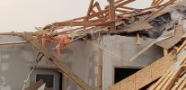
Boscobel WI tornado rated EF3, 150 mph.
So the tornado was the one who walked in on the homeowner "having some fun"? Geez that must be embarassing.One of the photographers at the local TV station I work for found a little humor in the Boscobel damage...
As of late morning, the Chicago Metro area is under a severe threat this afternoon, with tornadoes being possible.