• Welcome to TalkWeather!
    We see you lurking around TalkWeather! Take the extra step and join us today to view attachments, see less ads and maybe even join the discussion.
    CLICK TO JOIN TALKWEATHER

This severe weather season will be?

  • Much Above Average

    Votes: 4 9.3%
  • Above Average

    Votes: 26 60.5%
  • Average

    Votes: 6 14.0%
  • Below Average

    Votes: 5 11.6%
  • Much Below Average

    Votes: 2 4.7%

  • Total voters
    43
  • Poll closed .
Status
Not open for further replies.

South AL Wx

Member
Meteorologist
Messages
309
Reaction score
311
Location
Wetumpka, AL
Special Affiliations
  1. SKYWARN® Volunteer
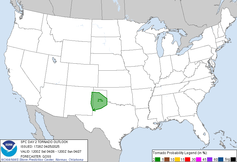
SPC has added a small slight risk for tomorrow across parts of MS/AL:
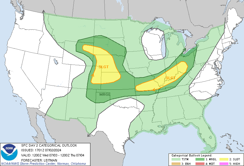
day2otlk_1730.gif


day2probotlk_1730_torn.gif
 
Messages
2,752
Reaction score
4,288
Location
Madison, WI
I want to watch how this all progresses another 4 to maybe 6 weeks. I want to see what kind of surface and sub-surface response we get to those enhanced trades with that standing IO wave in place since the strongest winds shown there look to be centered over the western and central ENSO regions. That will be important to the flavor of how the La Niña ends later down the road. I also want to see how the PDO continues to behave over the coming few weeks. The August PDO value was -1.25, but it's taken a short-term small step back when looking at the anomaly placement visually. I do expect that to be short-lived, however, as the large scale pattern continues to respond to the La Niña, and we had a peak of -1.75 last winter despite unfavorable ENSO. PDO seems to be pretty important to all this, and 2020's early season and spring severe showed that, especially January-April. Despite having an El Niño background state to work from, we mainly had polar jet-driven systems and ended up with a La Niña type system around Easter that produced one of the largest tornado outbreaks in U.S. history. I want to wait a few weeks to make sure the PDO is going to continue to respond to everything else going on.

But if all stays on the current course, color me very concerned. I've talked elsewhere about how the idea of the Niña ending west-based or Modoki is a big red flag because of the +TNI pattern it will set up. Overall, if everything stays on course, this is the large scale global pattern you historically look for in order for big things to happen in Dixie Alley during the late winter and spring. I have some disturbing statistics that a couple on here have privately heard IF we get a combo of this being a Niña at or below -1.0C, the PDO at or below -1.5, and a +TNI (and I think we exceed those conditions, as of now)... but I want to wait a little while longer before dropping things publicly in front of a larger audience.

So, it has now been about six weeks since this post. What say you, @Fred Gossage?
 

Fred Gossage

Member
Meteorologist
PerryW Project Supporter
Messages
596
Reaction score
2,095
Location
Florence, AL
So, it has now been about six weeks since this post. What say you, @Fred Gossage?
Give me a couple more weeks to watch how the coastal North Pacific continues to cool. That drives the -PDO. I have a decent handle on the ENSO, but I want to make sure I nail the North Pacific. That will be critical. So far, I see no reason to change my thoughts. I just want to watch this a little longer and make sure before I start trying to sound an alarm.

1603907270050.png

If the cooling in these areas continue, even though the overall North Pacific is warm, we end up with a significantly -PDO, which has a significant impact on the placement and intensity of the polar jet and also holding back any significant subtropical jet influences. All things still seem "go". I just want to make sure.
 
Messages
1,029
Reaction score
1,216
Location
jackson tennessee
Special Affiliations
  1. SKYWARN® Volunteer
This thread may be quite for now... but later look out ... looking like top analog with this Niña this winter is 98 99. Which was extremely active and violent severe wx wise that winter . The qbo looks to continue going more positive as winter rolls through .
 
Messages
2,752
Reaction score
4,288
Location
Madison, WI
This thread may be quite for now... but later look out ... looking like top analog with this Niña this winter is 98 99. Which was extremely active and violent severe wx wise that winter . The qbo looks to continue going more positive as winter rolls through .

'07-'08 has been thrown around as a possible analog, too. That winter featured the early January upper Midwest outbreak and the early February Super Tuesday outbreak across the mid-South and Dixie (the following late spring was also very active in the central Plains and upper Midwest).

However, 2007 didn't have the crazy active hurricane season and 2020 didn't have the Midwest flooding in August.
 
Last edited:

JayF

Technical Administrator
Staff member
Administrator
Moderator
Sustaining Member
Technical Admin
Messages
1,624
Reaction score
878
Location
Hartselle, al
HAM Callsign
KB4JCS

warneagle

Member
Messages
3,729
Reaction score
3,208
Location
Arlington, VA
Special Affiliations
  1. SKYWARN® Volunteer
Tornado watch is up in Missouri and Arkansas and a warning has already popped up in Missouri south of the Joplin area.
 

warneagle

Member
Messages
3,729
Reaction score
3,208
Location
Arlington, VA
Special Affiliations
  1. SKYWARN® Volunteer
We're about to get some severe thunderstorms here in the DC area. Hashtag second season.
 

MichelleH

Moderator
Moderator
Messages
860
Reaction score
1,174
Location
Cullman, AL
From Spann this morning. Thoughts?

THANKSGIVING WEEK: For now the chance of rain looks very low Monday and Tuesday, but models are beginning to agree on the potential for a fairly dynamic storm system to form over the Central U.S. that would bring rain and thunderstorms to Alabama on Wednesday.

The synoptic scale pattern would suggest potential for strong storms (this is the core of the late fall severe weather season in Alabama), but the amount of instability remains in question. Just too early to know if severe storms will be an issue, but clearly something to watch as we get closer. Dry air returns for Thanksgiving Day and "Black Friday" with highs in the 60s
 

bwalk

Member
Messages
597
Reaction score
291
Location
Prattville, Al
Well, Reed Timmer is getting stirred up re next week.


Reed Timmer Extreme Meteorologist
WATCHING DIXIE ALLEY for outside chance of a severe weather even including threat of tornadoes on the Wednesday before Thanksgiving. 12z Euro has the severe weather event unfolding across MS/AL, while GFS has a progressive system thru the Carolina Piedmont. Euro has a negatively tilted trough with surface low lifting through southern IL, with 60s dew points mostly holding in MS/AL south of TN border. GFS has oscillated between Dixie severe potential and a too progressive system run-to-run.

1605905670216.png


1605905708890.png


Status
Not open for further replies.
Back
Top