• Welcome to TalkWeather!
    We see you lurking around TalkWeather! Take the extra step and join us today to view attachments, see less ads and maybe even join the discussion.
    CLICK TO JOIN TALKWEATHER

This severe weather season will be?

  • Much Above Average

    Votes: 4 9.3%
  • Above Average

    Votes: 26 60.5%
  • Average

    Votes: 6 14.0%
  • Below Average

    Votes: 5 11.6%
  • Much Below Average

    Votes: 2 4.7%

  • Total voters
    43
  • Poll closed .
Status
Not open for further replies.
Messages
2,752
Reaction score
4,288
Location
Madison, WI
Day 3 outlook seems to represent a bit of a walk-back from the large Day 4 area outlooked yesterday. More in line with what the GFS/NAM were showing with the warm sector not getting as far inland. "King" EURO has been awfully over-bullish on both severe weather and winter storm potential in the medium range of late. I'm used to expecting that more so from the GFS.
 

Kory

Member
Messages
4,928
Reaction score
2,119
Location
Tuscaloosa, Alabama
Actually, the GFS has trended toward the Euro synoptically and the euro is far superior verification wise in the medium range...even still. GFS for several days now has had convective feedback and dragging the SLP south of 20/59 and is no longer doing that.

What we are seeing now is some entrainment of a small disturbance in the southern stream that kicks off a lot of convection across the warm sector and just forcing with the positive tilt trough fires off a lot of convection and we get wonky lapse rates and surface destabilization.

Storm mode will be messy but this feels like we get a storm or two that overperforms. Similar to the Hattiesburg 2013 storm day.
 

Kory

Member
Messages
4,928
Reaction score
2,119
Location
Tuscaloosa, Alabama
Yeah it’s hard to look past Wednesday’s event even though it will probably be marginal for some members on here. There is a decent parameter space setting up over LA/MS/AL for Wednesday and Southern half of Alabama into Florida Panhandle and South/Western GA into Thursday for severe wx. I think a convective mess is one of the larger inhibiting factors we need to keep an eye on especially as CAMs get into range.
 
Messages
1,029
Reaction score
1,216
Location
jackson tennessee
Special Affiliations
  1. SKYWARN® Volunteer
LOL. 10 Day is serious voodoo land. I hear you , but the odds are seriously stacked on a look completely different. :)


Sent from my iPhone using Tapatalk
Agree with fantasy land part... but the teleconnections r lining up for a big system that time frame ... h5 pattern on the euro is looking quite viotale to be honest
 

Mike S

Administrator
Staff member
Administrator
Moderator
PerryW Project Supporter
Messages
1,991
Reaction score
1,115
Location
Meridianville, Al
Special Affiliations
  1. SKYWARN® Volunteer
WAFF48's Brad Travis is warning of excessive rain next week, 5"-10" with strong storms possibly next Wednesday. Looks like we're in for another extremely wet February.

1580959155584.png
 
  • Thread starter
  • Moderator
  • #49

Taylor Campbell

Moderator
Moderator
PerryW Project Supporter
Messages
2,102
Reaction score
2,189
Location
Wedowee, AL
Special Affiliations
  1. SKYWARN® Volunteer
The last two runs of the EURO were aggressive for next Wednesday and Thursday. However, there still appears to be a lot of uncertainty for how next week’s pattern evolves. I’ll be keeping a close eye.
 

Kory

Member
Messages
4,928
Reaction score
2,119
Location
Tuscaloosa, Alabama
The last two runs of the EURO were aggressive for next Wednesday and Thursday. However, there still appears to be a lot of uncertainty for how next week’s pattern evolves. I’ll be keeping a close eye.
Yes, Euro and UKMET are notable threats. GFS is a lot of rain but not much of anything. CMC is in between. One things for sure. Lots of rain.
 

Kory

Member
Messages
4,928
Reaction score
2,119
Location
Tuscaloosa, Alabama
Are we looking at Wednesday 2/12 or Thursday 2/13?
The timing is fluctuating but it’ll be a Wednesday evening through Thursday midday threat. The problem with cut off lows is they meander and timing becomes a pain in the rear.

The rainfall next week will be the biggest story. I am afraid we will have very bad flooding per guidance. Looks like a band of rain stall over and just north of 20/59.
 

Kory

Member
Messages
4,928
Reaction score
2,119
Location
Tuscaloosa, Alabama
122 confirmed tornadoes now after this past event. 79 of those tornadoes occurring with the January 10-11th event. 2nd most active start to the year...right behind 2008 in the last 20 years.

We might add to that number with Wednesday’s system per the Euro
 
Last edited:

Weatherphreak

Member
Messages
351
Reaction score
336
Location
Huntsville
The Tennessee River here in South Huntsville is already very high. This may be TVA trying to get ahead of the next system but 5-10 inches will cause major problems over the next week if the river doesn’t drop before then.
 
  • Like
Reactions: KoD

Equus

Member
Messages
3,290
Reaction score
3,368
Location
Jasper, AL
Special Affiliations
  1. SKYWARN® Volunteer
unknown-27.png
I'm in Addison, Texas for the weekend totally unrelated to the weather aand here's a forecast sounding for central TX tomorrow. Neat
 

Bevo

Member
Messages
241
Reaction score
201
Location
Dallas, TX
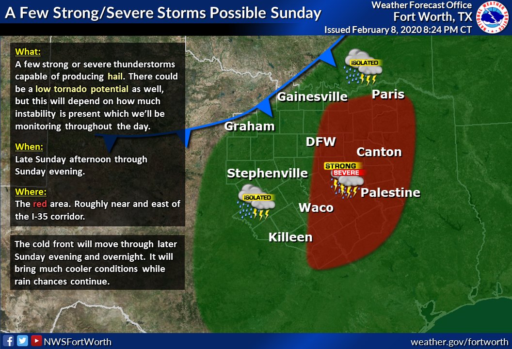
I feel like the potential for some severe weather has been downplayed for Texas over the past few days and now some media outlets have begun to take notice. Might be a "day of" scenario, though probably not widespread.

EQTQFJxU0AI9kco.jpg
 
Status
Not open for further replies.
Logo 468x120
Back
Top