• Welcome to TalkWeather!
    We see you lurking around TalkWeather! Take the extra step and join us today to view attachments, see less ads and maybe even join the discussion.
    CLICK TO JOIN TALKWEATHER

This severe weather season will be?

  • Much Above Average

    Votes: 4 9.3%
  • Above Average

    Votes: 26 60.5%
  • Average

    Votes: 6 14.0%
  • Below Average

    Votes: 5 11.6%
  • Much Below Average

    Votes: 2 4.7%

  • Total voters
    43
  • Poll closed .
Status
Not open for further replies.
  • Thread starter
  • Moderator
  • #22

Taylor Campbell

Moderator
Moderator
PerryW Project Supporter
Messages
2,102
Reaction score
2,189
Location
Wedowee, AL
Special Affiliations
  1. SKYWARN® Volunteer
The storm southeast of Hohenwald, TN has a 74dbz return, half dollar size hail, and 60 mph wind gust, but no frequent lightning. That’s different.
 

Peter Griffin

Member
Messages
95
Reaction score
68
Location
Newport, NC
The storms that rolled through NC yesterday resulted in a microburst that caused some damage to a school.


rolltide_130

Member
Messages
828
Reaction score
378
Location
Harvest, Alabama
Special Affiliations
For whatever it's worth, I think it's worth bringing attention back to this with the fires that have been going on in Australia.
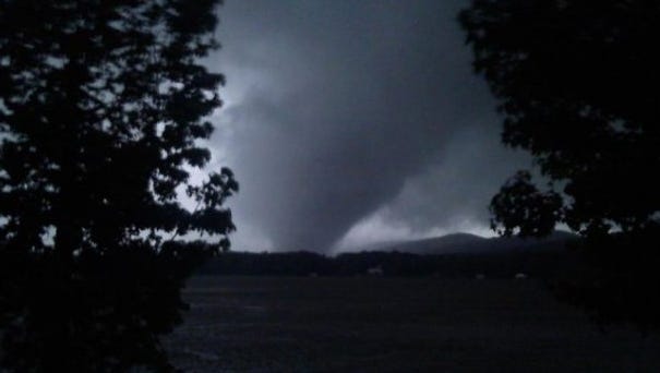

It's an interesting article but the smoke effect really needs to be studied more in detail. This study found it enhanced the effects while the general consensus is smoke played a huge part in the now infamous 45% bust back in May across OK. That's an area of study that needs to be explored more.
 

Peter Griffin

Member
Messages
95
Reaction score
68
Location
Newport, NC
It's an interesting article but the smoke effect really needs to be studied more in detail. This study found it enhanced the effects while the general consensus is smoke played a huge part in the now infamous 45% bust back in May across OK. That's an area of study that needs to be explored more.
Agreed I am pretty skeptical TBH. It says itself in the article that the models don't take into account things like smoke particles in the air. Even without that in the models all of the major tornado parameters we are aware of were pretty much off the charts leading up to this breakout. That day was going to be historical any way you slice it. I find it hard to believe some smoke had much if anything to do with it.
 

Jonathan Burleson

Member
Meteorologist
Messages
14
Reaction score
19
Location
Brilliant, AL
Special Affiliations
  1. SKYWARN® Volunteer
Next Tuesday/Wednesday looks like a potential severe wx threat across the Southeast. SPC is already entertaining an idea of introducing a severe wx risk for day 6 on tomorrow’s outlook should trends continue today.
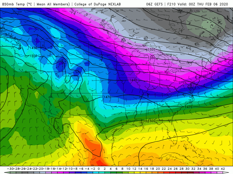
I look forward to seeing the new "Day 6" as it comes out, along with all the 0z model data tonight.
 
Messages
150
Reaction score
204
Location
Flowery Branch, GA
HAM Callsign
KM4JKH
Special Affiliations
  1. SKYWARN® Volunteer
BHM has decided to put a small stake in the ground...... of course that's a long way's out :) and probably will change.
1580510260717.png
 
  • Thread starter
  • Moderator
  • #35

Taylor Campbell

Moderator
Moderator
PerryW Project Supporter
Messages
2,102
Reaction score
2,189
Location
Wedowee, AL
Special Affiliations
  1. SKYWARN® Volunteer
Impressive adjustments on the GFS ensembles continue.
 
  • Thread starter
  • Moderator
  • #36

Taylor Campbell

Moderator
Moderator
PerryW Project Supporter
Messages
2,102
Reaction score
2,189
Location
Wedowee, AL
Special Affiliations
  1. SKYWARN® Volunteer
Impressive adjustments on the GFS ensembles continue.

AE390-DB3-4-EED-4-AAF-87-BD-A98-A082-B8839.gif
 

Kory

Member
Messages
4,928
Reaction score
2,119
Location
Tuscaloosa, Alabama
Some of the GEFS members are downright nasty. UKMET has come in with an extended threat from Wednesday into Thursday.
 

bwalk

Member
Messages
597
Reaction score
291
Location
Prattville, Al
Valid for Wednesday, 2/5/20. Clearly LOOKS like a really big tornado (image from Charles Edwards).

1580582153372.png
 
Last edited:
Messages
150
Reaction score
204
Location
Flowery Branch, GA
HAM Callsign
KM4JKH
Special Affiliations
  1. SKYWARN® Volunteer
Looks like a big timing difference between the 12z Euro & GFS. Euro is slower with more apparent CAPE for a longer period of time.
Will be interesting to see how the timing trends. The Euro would also increase storm threat in Georgia IMO.

2020-02-01_13-56-06.jpg

e 2020-02-01_13-58-47.jpg
 
Last edited:

Kory

Member
Messages
4,928
Reaction score
2,119
Location
Tuscaloosa, Alabama
Big question is how far south the front sags south on Tuesday/Tuesday night will determine the northward extent of surface instability. Euro/UKMET is keeping nearly all of Alabama in the warm sector where as the GFS and long range NAM sags it quite far south eliminating the threat for the northern 1/2 to 1/3 of Alabama Wednesday/Wednesday night. Unfortunately, model consistency isn't quite there yet...
 
Status
Not open for further replies.
Logo 468x120
Back
Top