MattPetrulli
Member
HRRR/NAM look very interesting, especially for the southern threat area.
Follow along with the video below to see how to install our site as a web app on your home screen.
Note: This feature may not be available in some browsers.


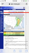
https://www.spc.noaa.gov/products/outlook/day1otlk.htmlThunderstorms should redevelop or intensify in advance of the cold
front this afternoon as large-scale ascent within the left exit
region of a 100-kt jet streak approaches the OH/TN Valley region.
Farther south, forcing becomes a bit more nebulous however a more
favorable thermodynamic environment with lower CINH will be in
place. Most CAM guidance maintains discrete or semi discrete storms
initially, with a transition to a more linear structure across
northern portions of the risk area with time due to stronger
large-scale forcing. Primary storm modes for storms that can persist
within the strong shear environment will be supercells and bowing
segments, with a risk for damaging winds, tornadoes, and large hail.
Should a corridor of stronger heating/greater instability develop,
confidence would increase regarding introduction of a significant
tornado risk area given the very favorable background environment.
This may be needed in later outlooks as the effects of ongoing
precipitation is assessed.
Definitely think the HRRR is worse case scenario. NAM isn’t as robust but still would cause some trouble.Something of note: BMX said in their morning AFD that the HRRR is the most aggressive of the CAMs, but it has run “too hot” in previous events.
I also like the southern target area more, but we'll see how it plays outIt looks to me that TN has the best dynamics and heating. I will be curious to see how the next few hours evolve. I figure if we can get in the mid 70’s we will have issues.
Definitely think the HRRR is worse case scenario. NAM isn’t as robust but still would cause some trouble.