• Welcome to TalkWeather!
    We see you lurking around TalkWeather! Take the extra step and join us today to view attachments, see less ads and maybe even join the discussion.
    CLICK TO JOIN TALKWEATHER

Severe WX Multi-day Severe Weather Threat 3/12-3/14/2019

Curious as to why we're seeing supercells going tornado warned so quickly this morning. Is there just that much shear for the storms to play with or what?
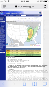
Yes. The ESRH in the area where those storms are popping is over 300 m2s2 (and much higher near the Paducah area, over 500 in some places) and the effective bulk shear is 60+ kt according to mesoanalysis.
 
Another confirmed tornado near Morganfield, KY. This storm will approach Evansville, IN soon.

..A TORNADO WARNING REMAINS IN EFFECT UNTIL 1045 AM CDT FOR
SOUTHEASTERN GALLATIN AND CENTRAL UNION COUNTIES...

At 1027 AM CDT, a confirmed tornado was located near Morganfield,
moving northeast at 60 mph.
 
Henderson County EMA reports a rain wrapped tornado near Smith Mills, KY. This is the same cell to the Southwest of Evansville.
 
There is some strong wording in here
 

Attachments

  • 3CB9B0D9-639A-4CFF-8D3E-29A028D84CB5.png
    3CB9B0D9-639A-4CFF-8D3E-29A028D84CB5.png
    503.4 KB · Views: 0
Isolated strong tornadoes
 

Attachments

  • 366BCB82-FA55-42A4-805B-DEA31754849F.png
    366BCB82-FA55-42A4-805B-DEA31754849F.png
    387.6 KB · Views: 0
Back
Top