- Admin
- #121
- Messages
- 3,618
- Reaction score
- 3,431
- Location
- Fayetteville, AR
- Special Affiliations
- SKYWARN® Volunteer
Memphis radar is down. They have techs onsite and working the issue.
Follow along with the video below to see how to install our site as a web app on your home screen.
Note: This feature may not be available in some browsers.
Memphis radar is down. They have techs onsite and working the issue.
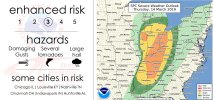
Agree 100 percent ... for what I’m seeing in long range teleconnections . April could get ugly ... stay tunedSo from Marginal here on D2 to 10%/hatched TOR on D1. It's gonna be one of those years