Kory
Member
We’ve got a couple long trackers in Southern IN.
Follow along with the video below to see how to install our site as a web app on your home screen.
Note: This feature may not be available in some browsers.
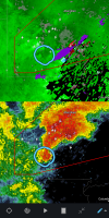
Yes they have...Strong unwarned couplet near Tremont MS. NWS Memphis has been super conservative lately.
Hook shape very similar to the Beauregard tornado earlier this month.That is an absolute monster approaching Seymour, IN.