• Welcome to TalkWeather!
    We see you lurking around TalkWeather! Take the extra step and join us today to view attachments, see less ads and maybe even join the discussion.
    CLICK TO JOIN TALKWEATHER

Severe WX May 2019 Plains Severe Event

A lot more variables than Monday, but yeah if things pan out, things could be volatile. Of course the highest tornado risk is in an area where flooding has closed a ton of roads so this isn't an good setup for anyone.
 
746d0a459bdf084d6414861f69f95f40.png


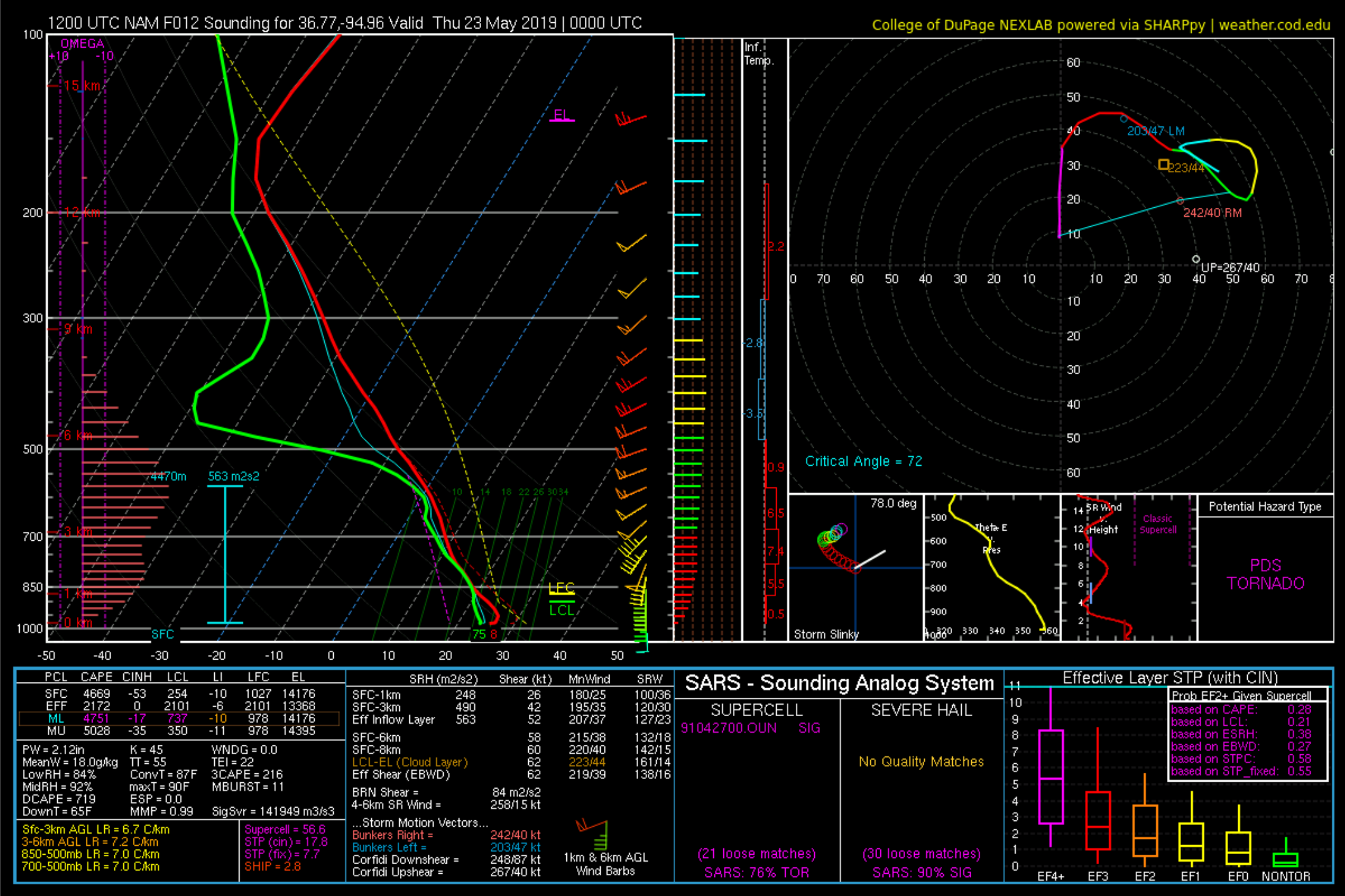
NAM 0000Z NE of Tulsa around the KS/MO/OK borders. Speaking of not being a good setup, looks to be a lot of HP supercells as well. Exactly what spotters don't need trying to do their jobs and exactly what Oklahoma doesn't need being flooded already.
 
Lil contaminated but jeez. Easily supportive of strong tornadoes if there's enough lift nosing in to get storms firing. IF that happens and they stay discrete, localized outbreak seems possible.
 
Hopefully people aren’t dumb enough to go chase in an area that’s already significantly flooded but I’m not holding my breath after some of the ridiculous stuff we saw the other day.
 
746d0a459bdf084d6414861f69f95f40.png


NAM 0000Z NE of Tulsa around the KS/MO/OK borders. Speaking of not being a good setup, looks to be a lot of HP supercells as well. Exactly what spotters don't need trying to do their jobs and exactly what Oklahoma doesn't need being flooded already.

Low-level shear is adequate but a bit lacking in my opinion. Cap isn't super strong but it is there. Definitely wary of putting my marbles in the HRRR basket, but I don't like it developing supercells throughout the day - - especially those that look to impact Oklahoma City and Tulsa.
 
Low-level shear is adequate but a bit lacking in my opinion. Cap isn't super strong but it is there. Definitely wary of putting my marbles in the HRRR basket, but I don't like it developing supercells throughout the day - - especially those that look to impact Oklahoma City and Tulsa.
That was my first thought actually, the biggest possible mitigating factors are a lack of low level shear and the cap. If the cap breaks we'll see some pretty explosive supercells, and if a storm is able to localize low level shear, some tornadoes as well.
 
16z surface obs show impressive temps and dews but a lot of cloud cover still lingering in central OK. If they can get a few hours of sun then it's game on since temperatures are running above NAM and HRRR indicated

1732
 
Yeah I'd counted out today completely until about 18 hours ago, it was looking like a quiet filler day between events and now I honestly think if we get initiation it could be far more destructive than Monday.
 
Just a hunch. Something big will happen in OK today.My meteorological reasoning will come later


Like I said this morning. And to my own meteorological reasoning...what that small CAP does, boundary interaction, and rapid moisture transport.
 
Back
Top