• Welcome to TalkWeather!
    We see you lurking around TalkWeather! Take the extra step and join us today to view attachments, see less ads and maybe even join the discussion.
    CLICK TO JOIN TALKWEATHER

Severe WX May 2019 Plains Severe Event


One of the comparisons made in this post was that the poor lapse rates could be compared to 4/14/12, as on a day that had poorer lapse rates, the storms still went up and caused significant damage. Looking at that sounding, however, the cap was significantly weaker on 4/14. On 4/27, the cap was about the same, but the lapse rates are stronger.

Looking at this, there could be one of two things going on: 1) Lapse rates have to be strong enough to overcome a stronger cap, and when the cap is stronger and lapse rates are weaker storms won't fire. This would be evidenced by 4/14 having a weaker cap and 4/27 having stronger lapse rates or 2) there's a variable we don't know about that's affecting storms being able to fire, whether it's something we already know of and aren't aware of the relevance or something else entirely.


0475fad82fc1c46b0f3773103d120b23.png
ecaefd0008e7ff009dae90db020261d1.png
ecda7a8efc593fbbd07502fb8408af21.png

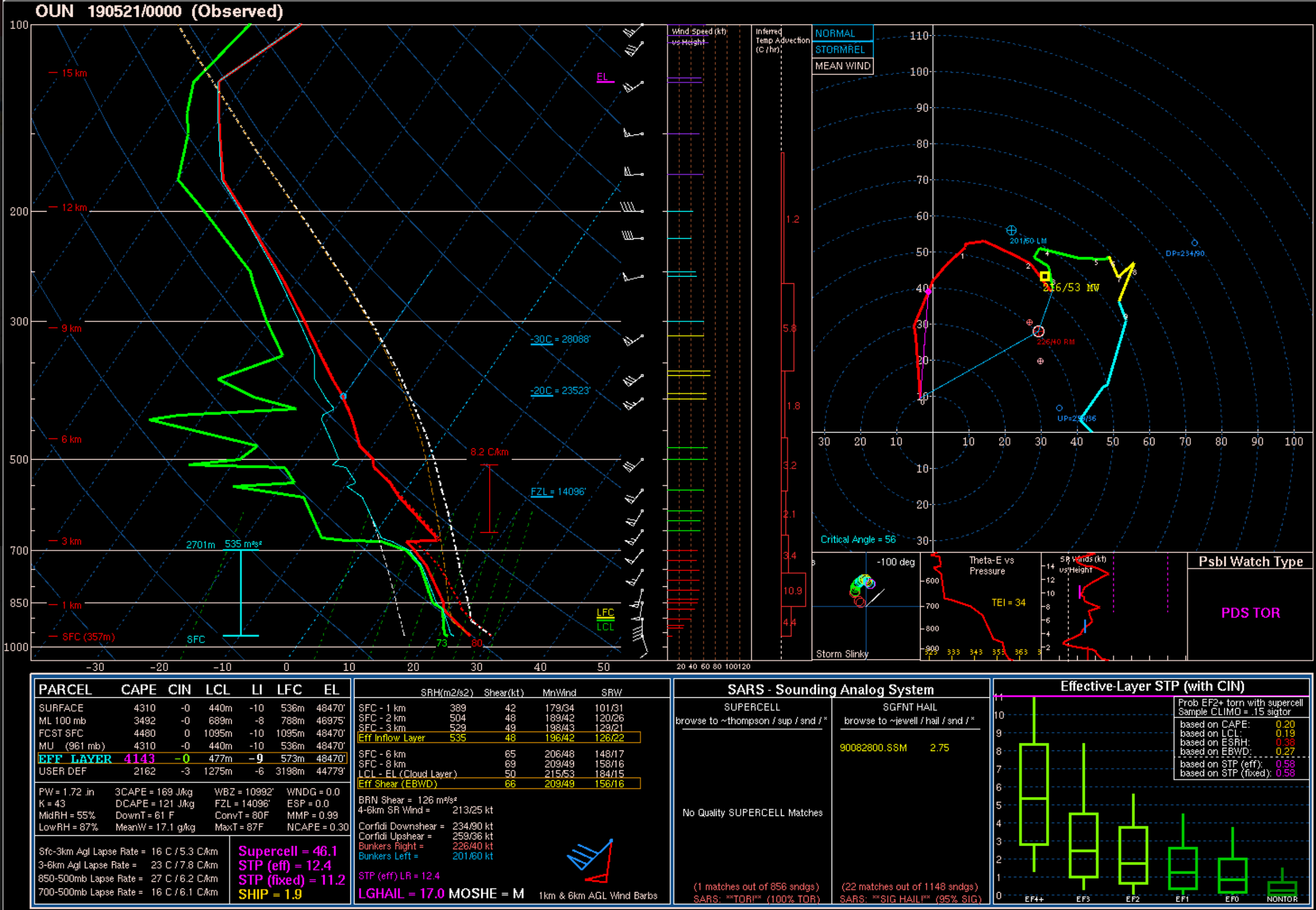
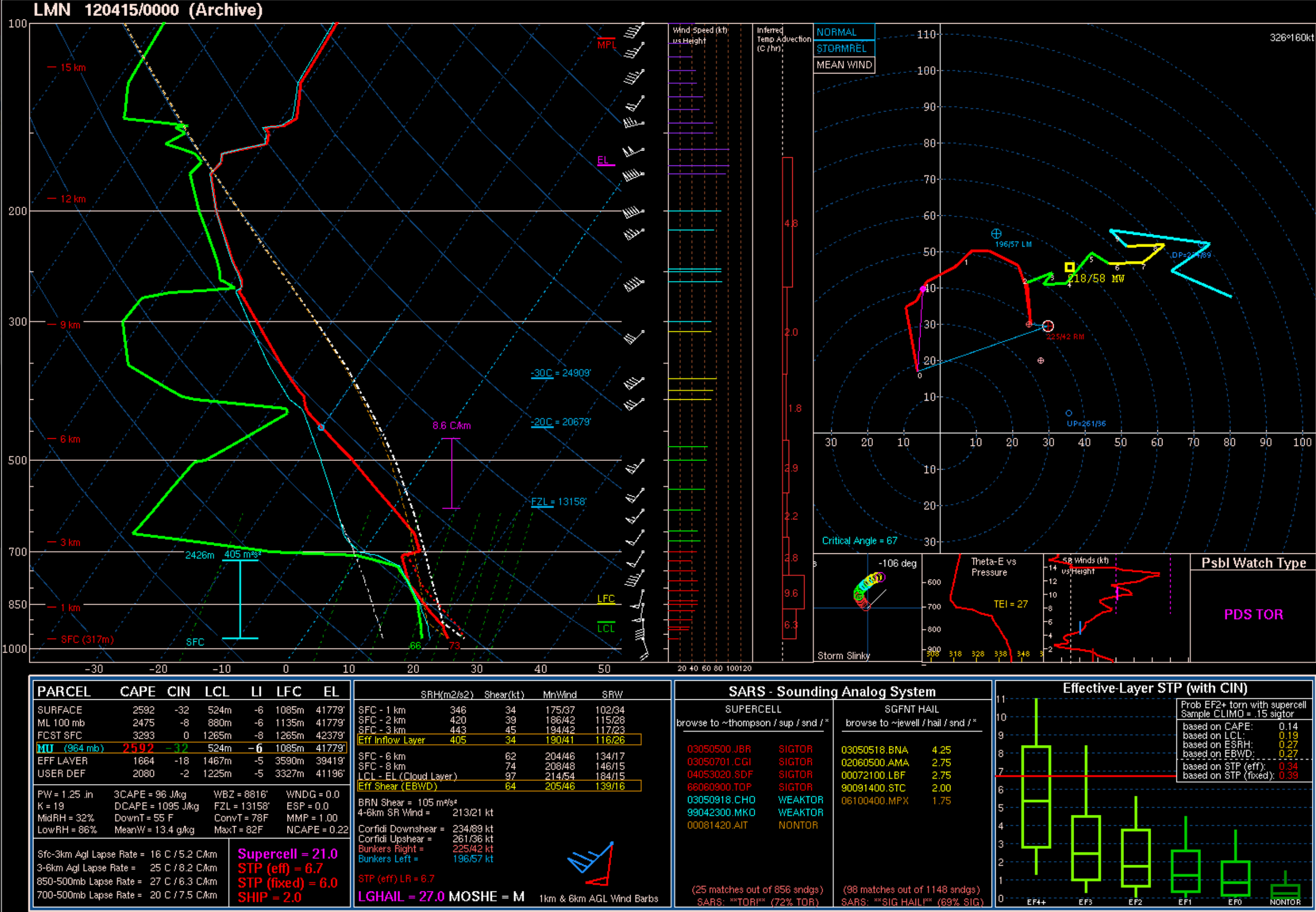
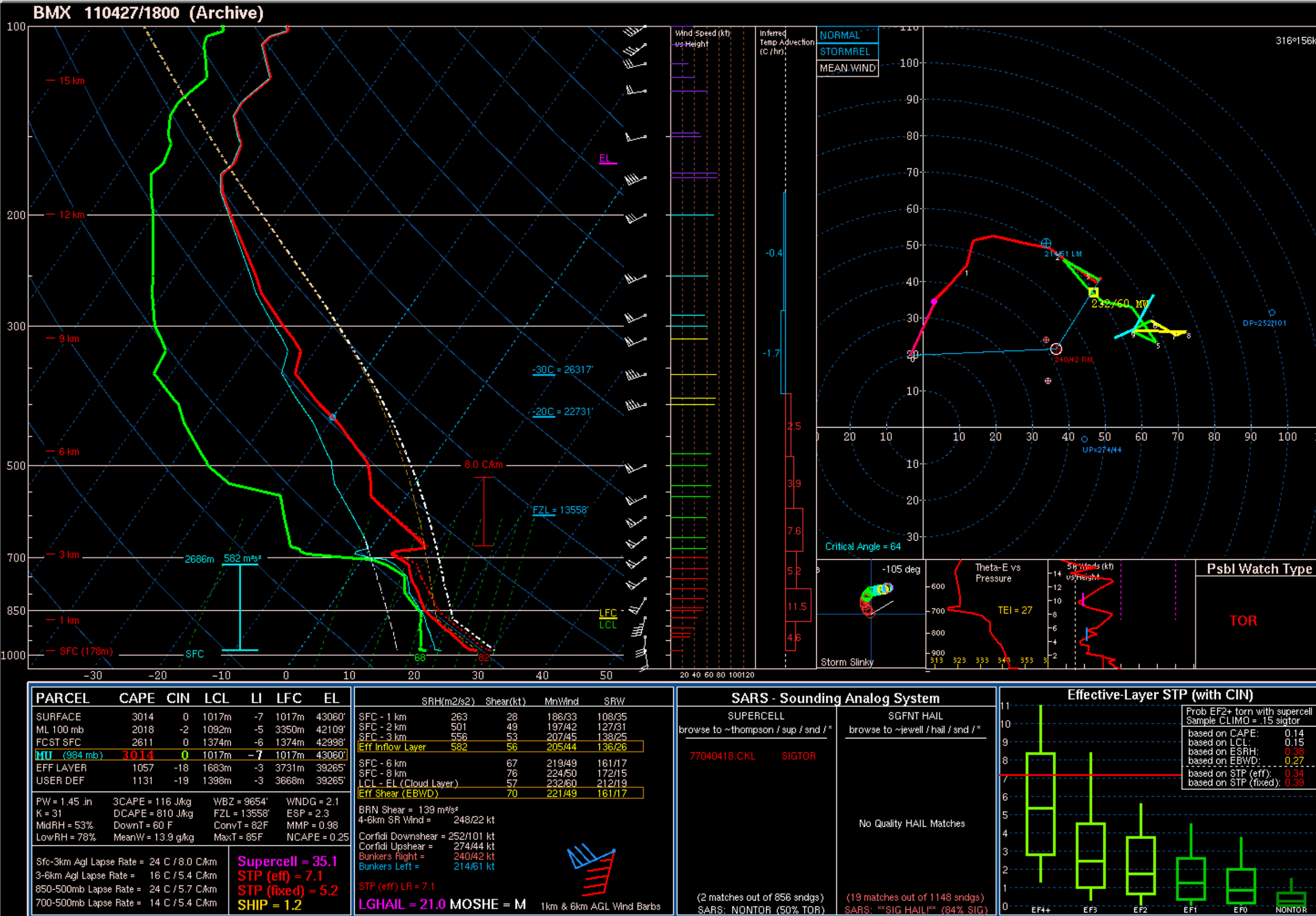
Here's all 3 soundings for those of you who don't want to look at the twitter thread. It's eerie how similar they are, and it indicates to me that there's something we just don't know yet.
 
I can’t find chasers on this tor...
 
It's a random QLCS spinup so not sure how many are in the area. It's weakening now but was very intense there for a minute
 
Another supercell with a textbook appearance is probably trying to drop a tor NW of Topeka. Lot of action this evening

Edit, PDS tor warning on that, large tornado NE of Delia, KS
 
Very large probably strong tornado just crossed from KS into NE. This, all in a SVR watch and entering the 2% tor probs on the outlook lol. Another supercell growing just N of Kansas City.

We have now officially surpassed yesterday in tornado reports with 30+.
 
Human nature will preclude us from ever eliminating natural disaster death tolls.

On another note, NAM 3k and HRRR (yeah, I know, I know) are now popping up convection in Oklahoma tornado in an environment expected to be dominated by height rises and other such mitigating factors BUT favorable for significant tornadoes in any cells that DO manage to get going. Might have some warnings tomorrow, who knows. After yesterday I am skeptical of the CAMs and I think morning soundings, observations, and features along the dryline are going to tell the story. 2019 is a weird year... I guess anything can happen. Sitting here watching isolated little supercells march across southern Illinois ahead of the line at the moment so I wouldn't BE shocked if weird stuff happened tomorrow.
 
The 00z HRW WRF-ARW and -NSSL are both blowing up big storms over central OK now too, but again, all the CAMs were wrong about yesterday so I want to take a peek at morning obs and soundings before starting to buy into those solutions. Capping and subsidence doesn't make me think it's going to be a big issue, buuuut, it's not something to just throw out either.
 
Who would have thought today of all days would have done stuff like this?

Sounds of that engine reminds me of a tank. Good catch!
 
So uh... Day One paints 10% hatched tor from Tulsa to Joplin. Many areas went from Marginal to Enhanced; very big change from Day Two outlook. But big questions on whether stuff can even initiate despite CAMs being aggressive on it.
 
Despite height falls and capping, yeah, today feels a little ominous. Not giving as much credence to CAMs as I usually do, but SPC, OUN, and TSA are all on the same page with it.
 
Back
Top