
My thoughts exactly - these guys are the pros though, the best of the best. I’m not being sarcastic eitherSeems like there would be a high risk area for the Mid-South. Kind of surprised its just the Northern portion of this event.
Navigation
Install the app
How to install the app on iOS
Follow along with the video below to see how to install our site as a web app on your home screen.
Note: This feature may not be available in some browsers.
More options
-
Welcome to TalkWeather! We see you lurking around TalkWeather! Take the extra step and join us today to view attachments, see less ads and maybe even join the discussion. CLICK TO JOIN TALKWEATHER
You are using an out of date browser. It may not display this or other websites correctly.
You should upgrade or use an alternative browser.
You should upgrade or use an alternative browser.
Severe WX March 30th- April 1st 2023 (South, Southeast, Ohio Valley, Upper Midwest)
- Thread starter Lake Martin EF4
- Start date
Jpgood97
Member
I’m interested in seeing how this progresses for the TN Valley. I never put too much stock into one particle model, but the helicity swaths have been pretty accurate for the last few systems as far as location. With that being said, all of north AL is in enhanced or slight risk and has solid UH swaths being painted the last 3 days. Wonder if we’ll see the moderate pulled further south, or if contamination and storm mode will mitigate the risk on eastward progression. As far as MS/TN/AR border…yikes
Sent from my iPhone using Tapatalk
Sent from my iPhone using Tapatalk
Equus
Member
First high since 3/25/21
The Level 4 Moderate Risk will probably be expanded south and east though including all of North MS into more of Western/Northwest Alabama.
cincywx
Member
shaping up to be quite a day. pds watch coming for the southern extent.
MESOSCALE DISCUSSION 0391
NWS STORM PREDICTION CENTER NORMAN OK
1044 AM CDT FRI MAR 31 2023
AREAS AFFECTED...ARKLATEX INTO PARTS OF THE MID SOUTH
CONCERNING...SEVERE POTENTIAL...TORNADO WATCH LIKELY
VALID 311544Z - 311745Z
PROBABILITY OF WATCH ISSUANCE...95 PERCENT
SUMMARY...THE THREAT FOR TORNADIC SUPERCELLS WILL INCREASE THIS
AFTERNOON. PDS TORNADO WATCH ISSUANCE IS EVENTUALLY EXPECTED FOR
PARTS OF THE REGION.
DISCUSSION...WEAK ELEVATED CONVECTION HAS BEEN ONGOING ACROSS PARTS
OF AR THIS MORNING, WITHIN A PLUME OF RICH LOW-LEVEL MOISTURE AND
ALONG THE PERIPHERY OF A LEAD SHORTWAVE MOVING ACROSS EASTERN
PORTIONS OF THE CENTRAL PLAINS. ADDITIONAL CONVECTIVE DEVELOPMENT
HAS BEEN NOTED RECENTLY INTO SOUTHEAST OK AND NORTHEAST TX.
WIDESPREAD CLOUDINESS WILL TEND TO LIMIT DIURNAL HEATING TO SOME
EXTENT, BUT GRADUAL WARMING AMID INCREASINGLY RICH LOW-LEVEL
MOISTURE WILL SUPPORT MLCAPE INCREASING INTO THE 1000-2000 J/KG
RANGE AND WEAKENING MLCINH WITH TIME.
AREA VWPS ALREADY DEPICT VERY FAVORABLE WIND PROFILES, WITH STRONG
LOW-LEVEL (0-1 KM SRH OF 200-400 M2/S2) AND DEEP-LAYER SHEAR
(EFFECTIVE SHEAR OF 60+ KT) EXPECTED TO PERSIST THROUGH THE DAY.
TORNADIC SUPERCELLS ARE EXPECTED TO EVENTUALLY EVOLVE ACROSS THE
REGION THIS AFTERNOON, WITH A FEW LONGER-LIVED SUPERCELLS CAPABLE OF
PRODUCING STRONG/INTENSE TORNADOES POSSIBLE, ESPECIALLY ACROSS AR
TOWARD THE MS VALLEY. ONSET TIMING OF THE GREATER THREAT REMAINS
SOMEWHAT UNCERTAIN, BUT ONE OR MORE TORNADO WATCHES WILL BE REQUIRED
BY EARLY AFTERNOON, WITH PDS TORNADO WATCH ISSUANCE EXPECTED ACROSS
PARTS OF AR TOWARD THE MS VALLEY.
TH2002
Member
- Messages
- 4,974
- Reaction score
- 11,116
- Location
- California, United States
- Special Affiliations
- SKYWARN® Volunteer
Not sure how the other models are handling the timing of peak convection in the Mid South but the GFS is showing the most conducive time for storms around 8 PM central tonight. Wouldn't be surprised if they decide to pull the trigger and upgrade that area to HIGH later on.Seems like there would be a high risk area for the Mid-South. Kind of surprised its just the Northern portion of this event.
Right where I thought it'd be lol
Gunna have a few wedges today
cincywx
Member
high risk coming for southern portion. wow.
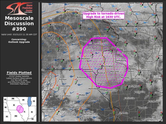
MESOSCALE DISCUSSION 0392
NWS STORM PREDICTION CENTER NORMAN OK
1047 AM CDT FRI MAR 31 2023
AREAS AFFECTED...PORTIONS OF EASTERN ARKANSAS...SOUTHWESTERN
TENNESSEE...AND NORTHERN MISSISSIPPI
CONCERNING...OUTLOOK UPGRADE
VALID 311547Z - 311645Z
SUMMARY...PORTIONS OF THE MODERATE RISK AREA OVER EASTERN AR,
SOUTHWESTERN TN, AND NORTHERN MS WILL BE UPGRADED TO A CATEGORICAL
HIGH RISK IN THE 1630 UTC CONVECTIVE OUTLOOK.
DISCUSSION...AN UPGRADE TO A TORNADO-DRIVEN HIGH RISK (30%
PROBABILITY) IS EXPECTED FOR THE 1630 UTC OUTLOOK. ENVIRONMENTAL
CONDITIONS ARE QUICKLY BECOMING FAVORABLE TO SUPPORT THE POTENTIAL
FOR NUMEROUS STRONG TO POTENTIALLY VIOLENT AND LONG-TRACK TORNADOES
ACROSS PORTIONS OF EASTERN AR, SOUTHWESTERN TN, AND NORTHERN MS.
PLEASE SEE THE FORTHCOMING DAY 1 OUTLOOK UPDATE FOR MORE
INFORMATION.
..LYONS/SMITH.. 03/31/2023
Geezhigh risk coming for southern portion. wow.
MESOSCALE DISCUSSION 0392
NWS STORM PREDICTION CENTER NORMAN OK
1047 AM CDT FRI MAR 31 2023
AREAS AFFECTED...PORTIONS OF EASTERN ARKANSAS...SOUTHWESTERN
TENNESSEE...AND NORTHERN MISSISSIPPI
CONCERNING...OUTLOOK UPGRADE
VALID 311547Z - 311645Z
SUMMARY...PORTIONS OF THE MODERATE RISK AREA OVER EASTERN AR,
SOUTHWESTERN TN, AND NORTHERN MS WILL BE UPGRADED TO A CATEGORICAL
HIGH RISK IN THE 1630 UTC CONVECTIVE OUTLOOK.
DISCUSSION...AN UPGRADE TO A TORNADO-DRIVEN HIGH RISK (30%
PROBABILITY) IS EXPECTED FOR THE 1630 UTC OUTLOOK. ENVIRONMENTAL
CONDITIONS ARE QUICKLY BECOMING FAVORABLE TO SUPPORT THE POTENTIAL
FOR NUMEROUS STRONG TO POTENTIALLY VIOLENT AND LONG-TRACK TORNADOES
ACROSS PORTIONS OF EASTERN AR, SOUTHWESTERN TN, AND NORTHERN MS.
PLEASE SEE THE FORTHCOMING DAY 1 OUTLOOK UPDATE FOR MORE
INFORMATION.
..LYONS/SMITH.. 03/31/2023
Muwx
Member
Double high risk. Has that ever happened before?
cincywx
Member
Double high risk. Has that ever happened before?
april 14, 2012 started that way.
Outlook upgrade MD’s (to High Risk) are pretty rare. Your usually already at High Risk with the morning update in many cases. A few this old timer can remember are Super Tuesday, 4/16/11, and I think a southern extension in the January 2017 Deep South outbreak. Any others recently?
Sent from my iPhone using Tapatalk
Sent from my iPhone using Tapatalk
notsoencrypted
Member
Oof, and Memphis inside that one. Really nervous about today.
Southern mode high risk coming too. Double-barrell high risk.
TornadoFan
Member
Guess I'll have to pull this out. Again.

Gail
Member
I hope everyone in that area knows how serious this is and takes it seriously. While I know they aren’t strangers to severe weather, I think most of the high risk days are around here and Oklahoma/Kansas area.
This aged well.This also sets up spatially for a high risk corridor. These type of days are why they issue high risks. They’ve made it clear in conversations and social media posts. We’ll see if the trigger is pulled at 1630z or a special update is released via MCD.
Again, confidence must be high that an area will receive convection (supercells), and that convection will have sufficient time within a parameter space that is supportive of tornadic supercells producing significant/violent tornadoes. This has that potential.
RollTide18
Member
Two different high risk areas today, has that ever happened?