• Welcome to TalkWeather!
    We see you lurking around TalkWeather! Take the extra step and join us today to view attachments, see less ads and maybe even join the discussion.
    CLICK TO JOIN TALKWEATHER

Severe WX March 30th- April 1st 2023 (South, Southeast, Ohio Valley, Upper Midwest)

Not sure how the other models are handling the timing of peak convection in the Mid South but the GFS is showing the most conducive time for storms around 8 PM central tonight. Wouldn't be surprised if they decide to pull the trigger and upgrade that area to HIGH later on.
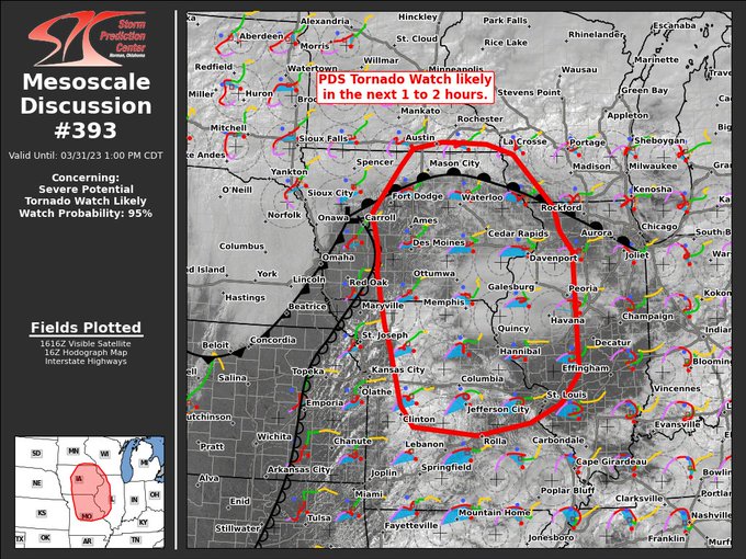
I post this and two minutes later, sure enough... hmm, did I speak too soon or too late?

Either way, I'm getting November '92 vibes from this setup...
 
I hope everyone in that area knows how serious this is and takes it seriously. While I know they aren’t strangers to severe weather, I think most of the high risk days are around here and Oklahoma/Kansas area.

I just messaged my friend in Cedar Rapids. They're likely paying attention as Cedar Rapids had some significant damage back in 2020 from a derecho, but I want him to be safe.
 
Wow, seeing a single high risk area these days is rare enough...
I guess I'd better unplug the phone charger from the outlet by the bed, and move it to the outlet by the sofa!
 
if anything, two distinct high risks highlight how far spc forecasting and technology has come. 20-30 years ago, you had high risks swallowing entire sections of the country. they are able to be very precise now. also, the use of the two high risks, which are issued very infrequently anymore, unfortunately highlights some serious confidence in a very bad day unfolding.

edit: i promise i did not see patrick marsh's tweet seeing basically the same thing o_O
 
Last edited:
Sitting at 60/53 now and sun really poking through. Will be curious if NE IL/Chicagoland gets added into more if not all MOD risk in next update.

Definitely unique day today. Never would have thought I'd see two high risks (maybe merge?) across two distinct geographical areas.
 
The energy in this from HRRR looks intense. With the Upgrade to that area, this is getting concerning real fast.

EHI.pngmcd0390.png
 
general question - how much will those small little temperature notch inversions on the soundings affect convection trying to fire in those areas?
 
I see two different ways this day could go down in the history books. It could either be "The Great Double High Risk SPC Forecasted Convective Amplification Deficiency" or "Devastating Tornado Outbreak of March 31, 2023" - because there's always the chance an event with an extremely high ceiling could Forecasted Convective Amplification Deficiency (5/20/2019) but I think we all know where this is unfortunately headed...
 
Fsj8IuLaAAARexy
 
Is this the earliest High risk ever issued this far north? The southern one is pretty normal, climatologically speaking, but the region of the northern one is usually more at risk of tornadoes in the summer months, not March.
Interestingly enough, there was a High Risk issued for the northern areas Missouri, Iowa, into Illinois on March 24th, 1988. Even more interesting is that the same areas were put under yet another High Risk on November 15th, 1988.
 
Back
Top