warneagle
Member
Yeah, I mean, you look at the thermos on the upstream soundings combined the kinematics that are going to be in place and that's a really worrying situation.approaching 3000 j/kg of cape before 10am on march 31st. what a setup.
Follow along with the video below to see how to install our site as a web app on your home screen.
Note: This feature may not be available in some browsers.
Yeah, I mean, you look at the thermos on the upstream soundings combined the kinematics that are going to be in place and that's a really worrying situation.approaching 3000 j/kg of cape before 10am on march 31st. what a setup.
Speaking of which, when do they typically do modifications to the D1 outlook? I thought the last scheduled mod was in the morning but occasionally they’ll do updates based off special soundings/weather balloons?A high risk will definetly be needed for the area around Illinois this afternoon.
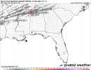
Mesoscale Discussion 0389
NWS Storm Prediction Center Norman OK
0906 AM CDT Fri Mar 31 2023
Areas affected...portions of South Dakota into western Minnesota
Concerning...Blizzard
Valid 311406Z - 312000Z
SUMMARY...To the north of a rapidly deepening surface cyclone,
widespread heavy snow and blizzard conditions are expected over
portions of SD and MN. heavy snow rates of 1-2 in/hr and widespread
low visibility from blowing snow are expected.
DISCUSSION...As of 1400 UTC, morning WV imagery showed a
well-developed upper low ejecting out of the central Rockies and
into the Plains. At the surface, an associated cyclone over eastern
NE and western IA is expected to rapidly deepen as strong height
falls and dynamic lift from the upper low pass overhead. Already
observed developing over portions of western NE and SD by regional
radar imagery, a broad precipitation shield should expand in
coverage and intensity through the next several hours in response to
the strong dynamic lift and mid-level warm advection. RAP soundings
across central and eastern SD are supportive of widespread heavy
snow with rates of 1-2 in/hr possible within banded structures.
Farther northeast strong mid-level warm advection has left a
resulting warm nose as observed by the 12z MPX sounding. This may
favor some mixed-phase precip and ice through the first part of the
afternoon. Snow should gradually expand northeastward into portions
of western MN tonight as the maximum in dynamic lift shifts with the
trough, and the lower temperature profile cools below freezing.
Concurrent with the risk for heavy snow, the surface low is expected
to rapidly deepen below 990 mb over IA and southern MN as it tracks
slowly northeastward through the day. Surface pressure falls on the
order of 1-2 mb per hour will support very strong gradient winds
along the backside of the surface low. 35-45 mph winds should
develop supporting widespread Blizzard conditions. Blowing snow and
poor visibility should first develop over central SD before slowly
expanding northeastward into eastern SD and MN later this evening.
Poor travel and dangerous winter weather conditions are most likely
over eastern SD this afternoon into the evening.
..Lyons.. 03/31/2023
...Please see www.spc.noaa.gov for graphic product...
ATTN...WFO...MPX...FGF...FSD...ABR...UNR...
Next updated Day 1 Outlook will be out by 10:30amSpeaking of which, when do they typically do modifications to the D1 outlook? I thought the last scheduled mod was in the morning but occasionally they’ll do updates based off special soundings/weather balloons?
Sorry if this is a stupid question, but is diurnal heating after cloud cover breaks up what causes a capping inversion to erode?Clouds are beginning to thin out over Mississippi. You can tell the Sun is trying to peek out over Smithville.
Yeah check out the 14z hrrr updrafts swaths now lol. Bonkers.Man, not a cloud in the sky in/around St. Louis.
Might be waiting for uptick in storm coverage for an afternoon-through-evening WW (they often issue separate watches for the morning convection).MCD had a 95% probability of a watch… MCD is gone and no watch. Don’t see that often.
Yeah my biggest fail modes would be the mode going linear too quickly - or the weird low level thermal/temperature inversions in the south14z HRRR with even more clearing this afternoon. I don't see a bust with this one. Junk convection could be a bit of an issue, but I think its going to be a rough night.
Yes as well as other factors. But yes that's basically it.Sorry if this is a stupid question, but is diurnal heating after cloud cover breaks up what causes a capping inversion to erode?
WouldNext updated Day 1 Outlook will be out by 10:30am
Yes, they issue a 1630z midday outlook. Will be out by 12:30 PM EDT/11:30 AM CDT. Zulu is a 4 hour adjustment now.Speaking of which, when do they typically do modifications to the D1 outlook? I thought the last scheduled mod was in the morning but occasionally they’ll do updates based off special soundings/weather balloons?
One of the unfortunate things about DST - we have to wait an extra hour for SPC outlooksYes, they issue a 1630z midday outlook. Will be out by 12:30 PM EDT/11:30 AM CDT. Zulu is a 4 hour adjustment now.