• Welcome to TalkWeather!
    We see you lurking around TalkWeather! Take the extra step and join us today to view attachments, see less ads and maybe even join the discussion.
    CLICK TO JOIN TALKWEATHER

Severe WX March 30th- April 1st 2023 (South, Southeast, Ohio Valley, Upper Midwest)

It was NE of Selmer, TN. I believe it is the 'Purdy Community Center'.

Had good connections and brick construction.

2145519
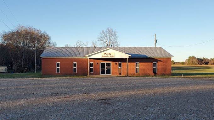
It didn’t look like it had…any…interior walls based on the fact that no wall marks are present on the slab floor…I’m probably wrong though considering the fact that…100% of brick buildings have interior walls Of some kind now a days….

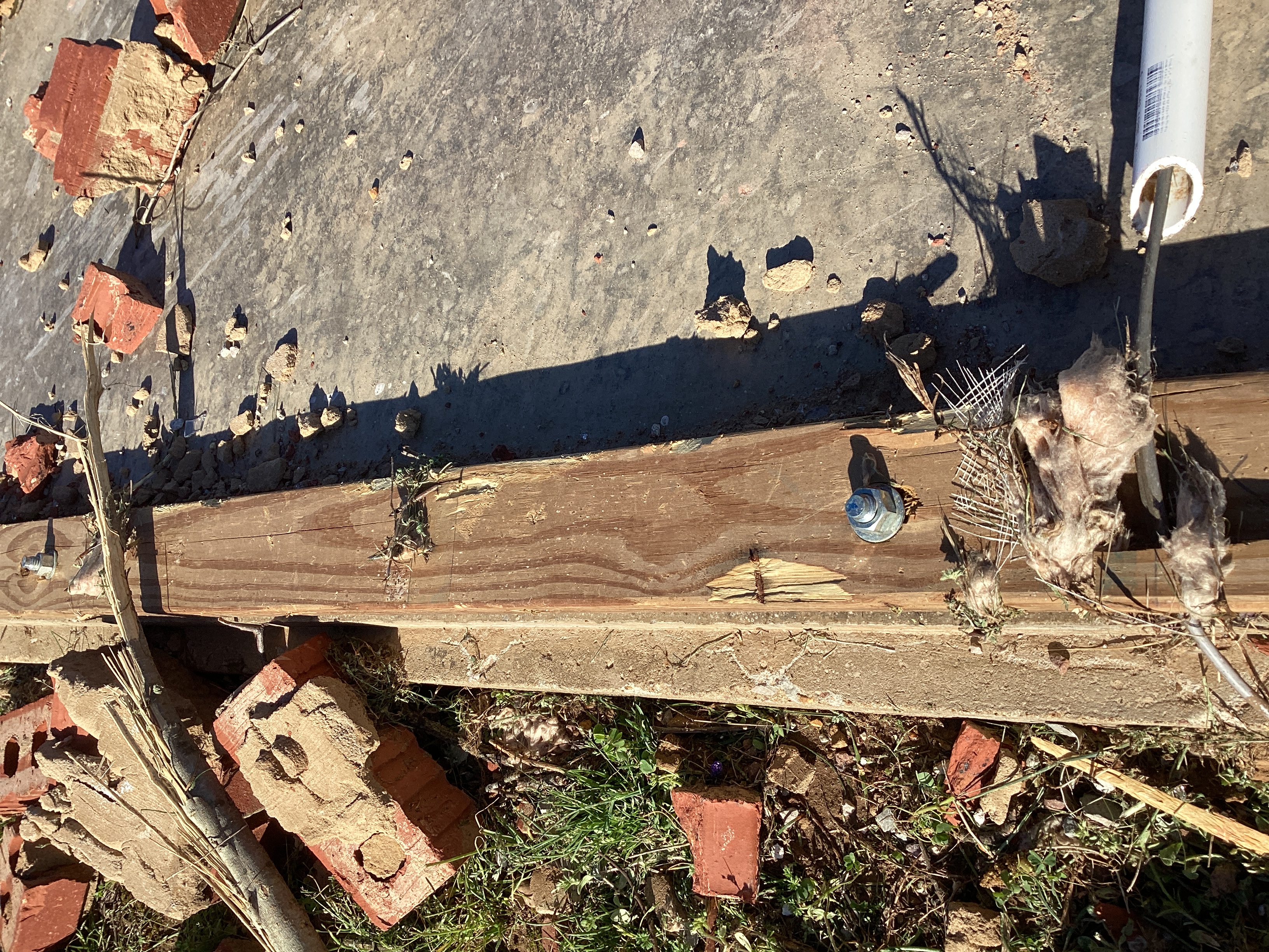
But if this one didn’t…yyeeahh that alone would compromise the structures stability and integrity 10 fold…
 
Per NWS standard practice a WFO has to call in a secondary, seasoned survey team to go above HE EF3. Perhaps MEG is taking the easy way out by deliberately inaccurately describing the damage (interior walls remain standing, sure buddy) so they can avoid having to do so.
 
Per NWS standard practice a WFO has to call in a secondary, seasoned survey team to go above HE EF3. Perhaps MEG is taking the easy way out by deliberately inaccurately describing the damage (interior walls remain standing, sure buddy) so they can avoid having to do so.
I still haven’t forgiven them for New Wren. That was such a half @ssed job they pulled there.
 
I still haven’t forgiven them for New Wren. That was such a half @ssed job they pulled there.
Holly Springs 2015 was almost worse, though it did at least get rated a LE EF4 (should have been EF5 though) unlike New Wren. In previous posts I've counted at least twenty homes along the Holly Springs path that went completely unsurveyed.
 
Holly Springs 2015 was almost worse, though it did at least get rated a LE EF4 (should have been EF5 though) unlike New Wren. In previous posts I've counted at least twenty homes along the Holly Springs path that went completely unsurveyed.
What were the reasons Holly Springs wasn’t a 5? Vilonia Syndrome a year later?
 
What were the reasons Holly Springs wasn’t a 5? Vilonia Syndrome a year later?
Same reason New Wren wasn't a 5. The Holly Springs Motorsports Park (the tornado's first peak in intensity IMO) was completely skipped by MEG and only documented thanks to an excellent survey by @CAL. Its second and primary peak intensity in the Lamar Rd vicinity was barely surveyed - MEG only surveyed one leveled home that wasn't even in the core of the damage path. The highest rated damage point was a large, well built home that was mostly slabbed despite the fact the tornado was already weakening when it struck.
 
It's still a better survey than some of MEG's more egregious ones, breaching the violent category is so near impossible now that 155 is a decent call compared to just not surveying the highest end stuff in events of the previous decade; really think 165 would be a better call if they don't want to go violent but at least the structures got looked at to begin with lol
 
Same reason New Wren wasn't a 5. The Holly Springs Motorsports Park (the tornado's first peak in intensity IMO) was completely skipped by MEG and only documented thanks to an excellent survey by @CAL. Its second and primary peak intensity in the Lamar Rd vicinity was barely surveyed - MEG only surveyed one leveled home that wasn't even in the core of the damage path. The highest rated damage point was a large, well built home that was mostly slabbed despite the fact the tornado was already weakening when it struck.
Yeah, that guy said that tornado damage was at least high-end EF4++
 
Not trying to make outright accusations here because hopefully it's still preliminary, but it almost seems like the Robinson survey was intentionally botched considering the area where aerial imagery shows potentially violent damage (and this being the area where it peaked on radar), that there's literally ZERO DI's along that portion of the path...


Wait what?

Just MEG doing MEG things. Absolutely ridiculous...
Also here's a photo of the asphalt scouring that occurred nearby. I'd love to hear an explanation, if there even is one. If you have to essentially lie about the state of the structure (ie "walls still standing") to get it down to the wind speed you want to rate it at, you're doing something wrong imo. Use the limits set by the scale, or don't survey. That's my two cents on this bs.
2145516
 
Last edited:
It's still a better survey than some of MEG's more egregious ones, breaching the violent category is so near impossible now that 155 is a decent call compared to just not surveying the highest end stuff in events of the previous decade; really think 165 would be a better call if they don't want to go violent but at least the structures got looked at to begin with lol
I can't say I agree, as I've seen recent tornadoes rated EF4 for seemingly less. EF4 isn't insanely difficult to get, and we see them every year, so I definitely wouldn't describe it as impossible, especially when you look at the EF4s of 2022. One of them was even based on a house that didn't have anchor bolts. In my opinion, this has much more to do with the specific WFO responsible for the survey, rather than the current state of the scale's application (at least when it comes to ratings below EF5).

Edit: After taking a closer look, I can see that this building appeared to entirely lack interior walls. This means that once roof or wall failure occurs, wind can rush the building's interior and quite literally "burst" it like a balloon. That may have been what happened here, but still, the anchor bolts, brick veneer, and pavement scouring (not that reliable I know, but still) still makes me uncomfortable with a rating in the EF3 range. The Chastain Manor clubhouse in Tuscaloosa was a similar type of structure, and still received an EF4 rating.
 
Last edited:
Not trying to make outright accusations here because hopefully it's still preliminary, but it almost seems like the Robinson survey was intentionally botched considering the area where aerial imagery shows potentially violent damage (and this being the area where it peaked on radar), that there's literally ZERO DI's along that portion of the path...
Is it possible they are still analyzing? I remember it took a while for the Pembroke-Black Creek, GA tornado to be upped to EF4 last year, and it wasn't til later that the violent damage points were added to the DAT. But still, I don't like the huge gap in DIs along with a lack of statements saying they are still working on the final rating.
 
Is it possible they are still analyzing? I remember it took a while for the Pembroke-Black Creek, GA tornado to be upped to EF4 last year, and it wasn't til later that the violent damage points were added to the DAT. But still, I don't like the huge gap in DIs along with a lack of statements saying they are still working on the final rating.
Hopefully that is what's going on, but the fact that it's been a week and there's literally two damage points for 20+ miles of path is questionable to say the least.
 
This area south of Robinson needs to be surveyed. That was a large home off of N White Tail Hollow Road that appears to have been completely destroyed. Also several other homes severely damaged in the area near N 1100th Street (appears to be an erratic damage pattern with multiple vortices). Not sure about the area SW of Robinson since the video ends there.

Screenshot 2023-04-06 at 8.49.36 PM.png
 
This area south of Robinson needs to be surveyed. That was a large home off of N White Tail Hollow Road that appears to have been completely destroyed. Also several other homes severely damaged in the area near N 1100th Street (appears to be an erratic damage pattern with multiple vortices). Not sure about the area SW of Robinson since the video ends there.

View attachment 19876
Judging by this video, there are at least 4-5 DOD 10 homes along that gap where's there's no damage information. It's not like those homes are inaccessible to the survey team either.
 
Back
Top