Equus
Member
Ah yes a day where the gradient winds are so strong the eventual intense QLCS actually feels like somewhat of a lull
Follow along with the video below to see how to install our site as a web app on your home screen.
Note: This feature may not be available in some browsers.
I’m planning to fill up a couple of gas cans for my portable generator just in case.Good thing I got my whole house generator serviced, and there aren't big trees right next to my home.
Yes!School buses would be a nightmare.


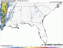
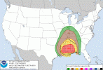
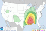
It's one reason why I'm a little confused with the tornado potential from SPC. We will definitely see QLCS spin-ups....but long track/strong? I feel like we need more instability for that.....and most of the unstable air will remain along the Gulf Coast tomorrow.It's very rare , but I can't remember the last long track tornado in a QCLS. The wind fields are scary with this event, thank goodness the cape is low with this event. I expect a lot of wind reports, and a lot of whack a mole with tornadoes on the radar.
Correct, I do remember that, but this isn't April 27, that's a 1/40 year event. I remember that also taking us by surprise. I know they can happen for sure,, but I'm just not sold on that happening. We could see 200 plus wind reports though.Morning QLCS on 4/27/11 produced numerous strong tornadoes, some of them fairly long-track even by discrete supercell standards (20-30ish miles). As with everything about that day, even cutting it in half would be a pretty exceptional event.
Several strong tornadoes (up to EF3) have occurred with nighttime QLCS's here in the upper Midwest, most recently in the Chicago area last year.
The 40 year return rate comments about 4/27 have always been strictly about the afternoon violent tornado outbreak, not about the morning QLCS. That was a serial derecho with embedded strong tornadoes, and even though that doesn't happen too often, it has been seen several times before. I just don't think the ingredients for that level of strong tornado QLCS threat will be with us. It would take likely 1500+ CAPE as the average in the instability axis, just based on the environmental profile that early morning, and we don't quite have that for this. But I do think a couple of tornadoes in the QLCS may be EF2 or maybe up to lower EF3 (we see that a good bit more often than a lot of people like to admit), and because of the fast storm motions, tornadoes of any intensity in the line may be a slight touch longer-tracked than they otherwise would be. But even if there are a couple of strong tornadoes in the line, the big deal tomorrow is going to be the widespread 70-80 mph wind swath with what will probably be a serial derecho.Correct, I do remember that, but this isn't April 27, that's a 1/40 year event. I remember that also taking us by surprise. I know they can happen for sure,, but I'm just not sold on that happening. We could see 200 plus wind reports though.
Problem is the short ones can happen between radar scans and by the time you warn for theme, they are already gone unless you get 1 or 2 that stay down for 10 minutes plus. It will be interesting to see how the nws warns tomorrow. I know Jackson will issue at least 15 tornado warningsThe 40 year return rate comments about 4/27 have always been strictly about the afternoon violent tornado outbreak, not about the morning QLCS. That was a serial derecho with embedded strong tornadoes, and even though that doesn't happen too often, it has been seen several times before. I just don't think the ingredients for that level of strong tornado QLCS threat will be with us. It would take likely 1500+ CAPE as the average in the instability axis, just based on the environmental profile that early morning, and we don't quite have that for this. But I do think a couple of tornadoes in the QLCS may be EF2 or maybe up to lower EF3 (we see that a good bit more often than a lot of people like to admit), and because of the fast storm motions, tornadoes of any intensity in the line may be a slight touch longer-tracked than they otherwise would be. But even if there are a couple of strong tornadoes in the line, the big deal tomorrow is going to be the widespread 70-80 mph wind swath with what will probably be a serial derecho.
I'm not a fan of the "generational outbreak" terminology anyway. I get why it's used to convey the rarity of days like 4/27/11, but it also implies that we won't see another day like that until around 2051. That's not how probability works, as we know.The 40 year return rate comments about 4/27 have always been strictly about the afternoon violent tornado outbreak, not about the morning QLCS. That was a serial derecho with embedded strong tornadoes, and even though that doesn't happen too often, it has been seen several times before. I just don't think the ingredients for that level of strong tornado QLCS threat will be with us. It would take likely 1500+ CAPE as the average in the instability axis, just based on the environmental profile that early morning, and we don't quite have that for this. But I do think a couple of tornadoes in the QLCS may be EF2 or maybe up to lower EF3 (we see that a good bit more often than a lot of people like to admit), and because of the fast storm motions, tornadoes of any intensity in the line may be a slight touch longer-tracked than they otherwise would be. But even if there are a couple of strong tornadoes in the line, the big deal tomorrow is going to be the widespread 70-80 mph wind swath with what will probably be a serial derecho.
Me neither. I'm of the opinion that another event like that will happen when the atmosphere supports it, whether it is next month or it waits until 300 years from now.I'm not a fan of the "generational outbreak" terminology anyway. I get why it's used to convey the rarity of days like 4/27/11, but it also implies that we won't see another day like that until around 2051. That's not how probability works, as we know.
Correct! The am outbreak was bad enough but not the "generational" event that pm. Birmingham has "lucked" out over the last year with severe weather threats reduced by flooding rains. I use the quotes cause the floods have caused death & destruction on their own. Didn't Easter 2020 also feature EF2-3s in the QLCS line?The 40 year return rate comments about 4/27 have always been strictly about the afternoon violent tornado outbreak, not about the morning QLCS. That was a serial derecho with embedded strong tornadoes, and even though that doesn't happen too often, it has been seen several times before. I just don't think the ingredients for that level of strong tornado QLCS threat will be with us. It would take likely 1500+ CAPE as the average in the instability axis, just based on the environmental profile that early morning, and we don't quite have that for this. But I do think a couple of tornadoes in the QLCS may be EF2 or maybe up to lower EF3 (we see that a good bit more often than a lot of people like to admit), and because of the fast storm motions, tornadoes of any intensity in the line may be a slight touch longer-tracked than they otherwise would be. But even if there are a couple of strong tornadoes in the line, the big deal tomorrow is going to be the widespread 70-80 mph wind swath with what will probably be a serial derecho.