Casuarina Head
Member
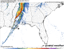
While very damaging winds appear to present a significant threat, I am still very skeptical about the potential for an “outbreak” including EF2+ tornadoes. An isolated discrete cell and QLCS spin-ups may occur, but the overall setup simply does not portend an outbreak. One would need more instability and a broader-based trough to favour an outbreak with EF2+ events. Nevertheless, the wind alone is very disconcerting, but at least the overnight threat should not be very significant at this rate.An appreciable severe-weather risk appears increasingly likely
across the Lower Mississippi Valley and Middle Gulf Coast region on
Wednesday/Day 4. This includes the potential for widespread damaging
winds and tornadoes, including the possibility of a regional tornado
outbreak including strong (EF2+) tornadoes.
From the SPC.