- Thread starter
- #101
DetectiveWX
Member
Not to draw comparisions and criticism, but I'm getting the April 4-5, 2011 vibes or more recently the Dec 15 derecho outbreak.
Follow along with the video below to see how to install our site as a web app on your home screen.
Note: This feature may not be available in some browsers.
Speaking on the tornado threat only, I've got a bad feeling that we will see a bad tornado come out of the southern more semi-discrete mode, especially late in the evening in the Mobile and Florida Panhandle region as broken supercells and a semi-discrete mode are expected to interact with better wind shear and kinematic support as the night goes on. There will undoubtedly be multiple spin-ups within the line, but those will probably be very hard to track and see.
Yeah we kind of got some of that in the same area with the last system, which is what produced the New Orleans tornado. If we get that kind of broken line structure like that again, it could be even worse given the wind fields. Obviously this system is going to be a big problem regardless due to the straight-line wind damage potential, but the idea of getting semi-discrete storms going in the presence of these dynamics is not a pleasant one to contemplate.HRRR has certainly been...disconcerting in that regard. 00Z run held serve with that look.
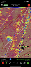
The NAM hodos for LA has been disturbing for tomorrow00Z HRRR seemed to pull some UH further east than last run.View attachment 12955
No, these would still be severe thunderstorm warnings. However, if a severe thunderstorm warning is tagged for 80 mph winds, it now triggers the wireless emergency alerts on mobile devices. Many EMA offices and city/county officials will also sound sirens in cases like that.So would NWS offices issue tornado warnings for thunderstorms with 80+ mph winds? James Spann is harping to treat tstm warns like tornadoes Wed nite.
Yes I was about to say the same thing and I do recall Svr Tstorm Warnings triggering alerts when winds get to certain epic levels in the past.No, these would still be severe thunderstorm warnings. However, if a severe thunderstorm warning is tagged for 80 mph winds, it now triggers the wireless emergency alerts on mobile devices. Many EMA offices and city/county officials will also sound sirens in cases like that.
This is actually a new thing that has just recently started (first made official back in the summer), with the inclusion of tiered impact tags to severe thunderstorm warnings. When a severe thunderstorm warning gets a "destructive" impact tag in the text, either for 80+ mph winds or baseball or larger hail, wireless emergency alerts will now get triggered.Yes I was about to say the same thing and I do recall Svr Tstorm Warnings triggering alerts when winds get to certain epic levels in the past.
.png")
...Parts of eastern LA...much of MS...AL...FL Panhandle...
Southern portions of the front/dryline will move much slower
compared to farther north, resulting in a longer duration of
boundary-layer moistening. A line of convection should become
evident by 21Z from southwest MS into parts of southern LA, moving
across MS and into north-central AL by about 03Z. The subtle lift,
combined with ample low-level moisture beneath an intense low-level
jet, will favor tornadic supercells which may peak during the night.
Effective SRH will remain high, averaging 400-500 m2/s2, with proper
hodograph elongation in the mid and high levels. Given the long
duration and slow eastward movement of this line of supercells, and
the magnitude of the forecast hodographs, a few intense tornadoes
could occur. However, the threat will become limited late in the
period due to decreasing instability to the east of about longitude
86W.
Great! I had actually asked about severe storm "levels" at Basic Skywarn Training last week (advanced was last night, great timing) & there are 3 not just 2. So all EMAs follow the 80+ mph wind/2.75" hail emergency rules. Baseball size hail probably won't be a problem this go round though. I had asked/wondered about a PDS Severe Thunderstorm Watch for this system as the wind threat is there. But given the likelihood of embedded tornadoes that might not work. The last PDS tstm watch had 95/90 wind threats but just 20/20 tornadoes. 95/90 winds but with 50 torn probs is more likely today-tonight. Could/Would the SPC issue a PDS Tornado watch but for straight line winds & not tornadoes?This is actually a new thing that has just recently started (first made official back in the summer), with the inclusion of tiered impact tags to severe thunderstorm warnings. When a severe thunderstorm warning gets a "destructive" impact tag in the text, either for 80+ mph winds or baseball or larger hail, wireless emergency alerts will now get triggered.
Yeah I thought that the SPC might expand Moderate a little further east. Birmingham is basically there (west Jeffco & Bessemer is) but I thought at least to Pell City & Sylacauga would go Mod. The SPC has split Jeffco AL a lot lately. I guess by now we know that they won't go High for just extreme straight line winds threats today & tonight.Moderate maintained on new D1; significant expansion of 15 hatch tornado risk, interestingly enough
View attachment 12956
Without a doubt I know the alerts coming out on cell phones are newer so to say, I guess I’m referring to earlier days when there was a time or two they did the whole tornado sirens procedure when it was “just” a high end severe thunderstorm with high winds. I recall there even being a debate on when to go there with tstorm winds alone but this was years ago.This is actually a new thing that has just recently started (first made official back in the summer), with the inclusion of tiered impact tags to severe thunderstorm warnings. When a severe thunderstorm warning gets a "destructive" impact tag in the text, either for 80+ mph winds or baseball or larger hail, wireless emergency alerts will now get triggered.