• Welcome to TalkWeather!
    We see you lurking around TalkWeather! Take the extra step and join us today to view attachments, see less ads and maybe even join the discussion.
    CLICK TO JOIN TALKWEATHER

Severe WX March 23-25th, 2023

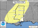
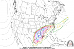
GFS is suggesting this will be yet another I-20 and south event. Not sure what it's doing with the moisture between FH084 and 108, when a broad warm sector of >60 dewpoints drastically shrinks even as the surface low intensifies, which you'd think would yield greater poleward moisture flux.

Could be one of those annoying patterns for chasers/severe wx enthusiasts where an early season pattern that would otherwise yield something big gets limited by an ill-timed cold air scouring of the Gulf like we had recently, after it had stayed relatively warm all winter until then.

OTOH, about 100 hours ago the GFS had the surface low for this event tracking through Minnesota with dewpoints barely touching 50 at the triple point, so...
 
You didn't do you job again Kevin, I hereby revoke your thread making privilege and give it to lake martin ef4.

Jk lol your following your own word, nonetheless a potent weather event looks to be on its way
The last thread I created about wore me out :D 
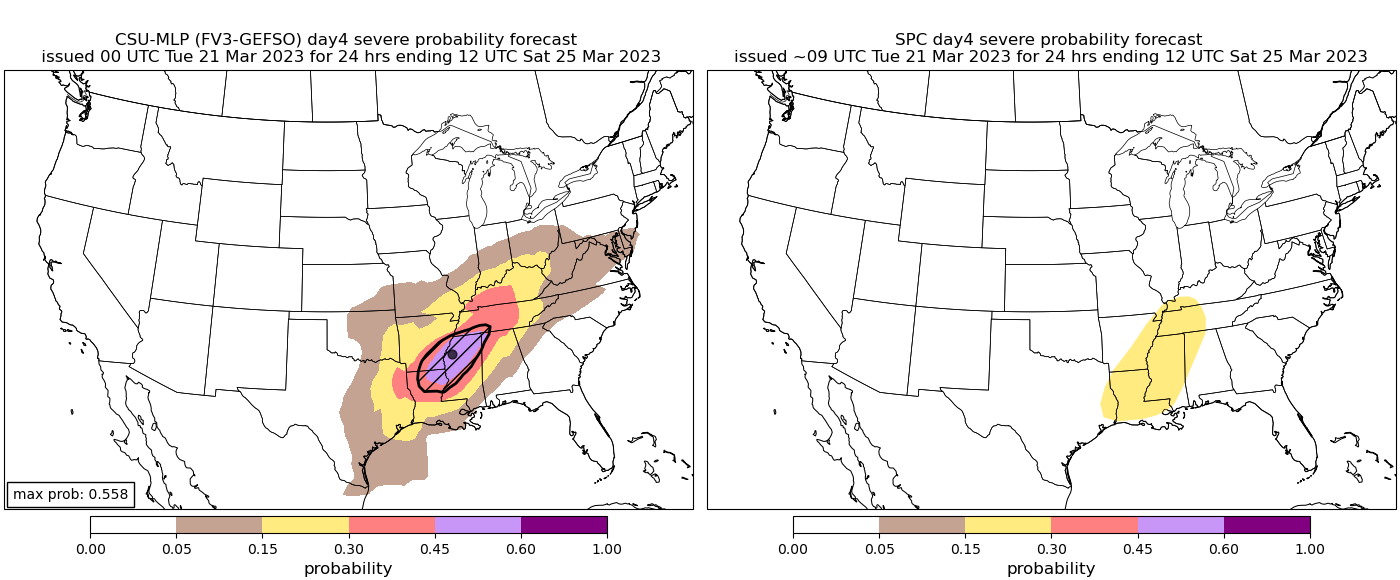
I have decided not to really pay attention to ANY system until about D3, so I probably won’t create any threads anytime soon. Anything D4+ can change waaay too much and I have grown tired of the model uncertainty and flip flopping leading up to the event.

I still get email alerts when someone DOES create a new “Severe Wx threat..” thread OR makes a comment in the Severe Wx 2023 thread. I still want a heads up about severe weather in my area (W Central GA/E Central AL), but I take it with a grain of salt…. (Until D3 hahahahha).

Im still here:
Mr Bean Thumbs Up GIF
 
I'd say a pretty robust event is coming up at the end of this week, (Friday) if models hold true a barely sub 1000mb low and potentially around a 1000sbcape spells trouble typically for our area.

Past analogs.. ✓
Look test..✓
Potentially a good mesh of not extreme shear and not a extreme lack of instability ✓
Reminds me of a similar event a few years back...march 25th 2021 maybe?.. from a quick glance didn't have extreme instability nor extreme shear and relative lack of dry air for the Alabama vicinity.

Actually verified instability topped 1700sbcape on the bham sounding that day so maybe a good bit higher instability that day than compared to forecasts for this Friday.

Currently doesn't look like Alabama is the prime zone though, more like missippi and potentially into west Alabama if I had to guess...

Lots more data to pour over into coming days.
 
Last edited:
My forecasted high for Friday is near 85. The record high temperature for Tupelo, MS in March is 89. Set back in 2020 and 2016. The record high temperature for Aberdeen, MS in March is 95 set back in 1929. It's possible that Tupelo could get near that record high on Friday.
 
This might turn out to be more of a heavy rain/flash flood event for North MS and Mid-South region than a severe weather event. BUT having said that, we've seen with these recent events where the models have to play catch up (plus we know how models handle the instability/moisture return) so you can't totally rule out a significant severe weather threat over a greater area. A lot to nail down during the next few days. Might do another updated graphic tomorrow.
 
Several of the GFS ensemble members show a significantly healthy supercell composite parameter set Saturday at 06z (1am Central Time). The operational EURO has also shown a favorable influx of instability and shear late in the period into Alabama.
 
Seems like a decent consensus between the two major models on ideal ejection path. Seems like it's sticking some.

Seems like instability will struggle to become robust, probably end up being a low cape event, unless mesoscale models uptrend.
 
Latest from SPC concerning Friday.
 

Attachments

  • MS_swody4_PROB.png
    MS_swody4_PROB.png
    322.8 KB · Views: 0
  • 202303210859_SWOD48.png
    202303210859_SWOD48.png
    74.6 KB · Views: 0
12z NAM shows a strong low level jet of 50 knots.

Both the NAM and GFS are big on the severe threat across far east Texas, northern LA, southern AR to western MS. Point soundings show enlarged effective inflow layer and significant low-level wind turn.
 
Last edited:
12z NAM shows a strong low level jet of 50 knots.

Both the NAM and GFS are big on the severe threat across far east Texas, northern LA, southern AR to western MS. Point soundings show enlarged effective inflow layer and significant low-level wind turn.

Yeah, the 12Z NAM in particular checks a lot of boxes for a significant tornado event across most of that area (and a larger portion of the region than the GFS has been showing).

Caveats:

1.) It's at the far end of its range.

2.) There's some pretty significant mid-level backing on forecast soundings along the dryline (although soundings further out in the warm sector, and particularly along the warm front, don't have it).
Yeah one thing I noticed is the NAM is a lot slower, kindve throws a wrench in which areas see a bigger threat.
 
Was waiting on the new nam run seems like it's lagging behind on releasing or either the time change has skewed my internal release schedule haha
 
12z NAM CWASP and precipitable water values.
 

Attachments

  • PWTRnam212F084.png
    PWTRnam212F084.png
    293.3 KB · Views: 0
  • CWASPnam212F084.png
    CWASPnam212F084.png
    277.5 KB · Views: 0
It's a little too quiet on this thread with an impending severe wx threat. LOL!
 
Lol, I think we've seen so many busts, it's sucked the life out of us haha
That’s exactly why, at least in my case. I was actually thinking about this today, when was the last time we had a severe threat with good model agreement, decent parameters, and one that actually verified? We had the early January Dixie Surprise but was it the November 4th outbreak? Not really sure to be honest.

I can’t remember if there was something else that wasn’t very well forecasted on the Nov 4th outbreak, was it the instability?

Whether it be possibly wonky model Parameterization, the ingredients not lining up in the right way yet, or it’s just going to be one of those seasons is yet to be seen.
 
Last edited:
Back
Top