warneagle
Member
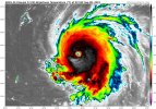
Pressure below 930 mb according to the dropsonde
Follow along with the video below to see how to install our site as a web app on your home screen.
Note: This feature may not be available in some browsers.
Pressure below 930 mb according to the dropsonde
A beauty.
939
WTNT43 KNHC 080252
TCDAT3
Hurricane Lee Discussion Number 11
NWS National Hurricane Center Miami FL AL132023
1100 PM AST Thu Sep 07 2023
The Air Force Reserve Hurricane Hunters have found that Lee has
skyrocketed to category 5 strength. The aircraft measured peak
700-mb flight-level winds of 148 kt and trustworthy SFMR winds
slightly over 140 kt, and dropsonde data shows that the minimum
pressure has plummeted to 928 mb. Based on these data, the initial
intensity is set at 140 kt, and Lee's maximum winds have increased
by an incredible 70 kt over the past 24 hours. The hurricane has a
clear 15 n mi-wide eye, with an infrared eye temperature as warm
as 21 C surrounded by convective cloud tops as cold as -76 C.
Additional strengthening appears likely, as Lee remains in a
low-shear environment and over very warm waters near 30 degrees
Celsius, and there are no signs of an imminent eyewall replacement.
In fact, based on guidance from UW-CIMSS, the probability of a
secondary eyewall formation during the next 24 hours is well below
climatology. There is some chance that moderate deep-layer
southwesterly shear could develop over the hurricane, but this
could be offset by strong upper-level divergence and thus have
little to no impact. To account for the recent rate of
intensification, the NHC intensity forecast is slightly above the
IVCN and HCCA consensus aids and shows a peak intensity of 155 kt in
12 hours. Amazingly, the 1800 UTC HAFS-A and -B runs show a peak
intensity between 170-180 kt, but that's getting into rarefied air.
The NHC forecast will be adjusted accordingly if those solutions
begin looking like a more distinct possibility. Only very gradual
weakening is shown after 12-24 hours, and it is likely that Lee's
intensity will fluctuate for much of the forecast period. Lee is
forecast to remain a dangerous category 4 or 5 hurricane for the
next 5 days.
For the next 5 days--through next Tuesday evening--Lee is expected
to maintain a steady west-northwestward track, passing well to the
north of the northern Leeward Islands, the Virgin Islands, and
Puerto Rico. The hurricane is currently moving at about 12 kt, but
it is expected to slow down considerably through early next week as
the steering ridge to its north builds southwestward, effectively
blocking Lee's progress. The NHC track forecast remains of high
confidence through day 5, and again, no significant changes were
required from the previous forecast. Although there are some
indications that Lee might begin a northward turn around the middle
of next week, it is still way to soon to focus on specific model
scenarios that far out into the future.
KEY MESSAGES:
1. Lee has become a dangerous category 5 hurricane, and further
strengthening is forecast overnight. Lee's core is expected to move
well north of the northern Leeward Islands, the Virgin Islands, and
Puerto Rico this weekend and early next week.
2. Dangerous surf and life-threatening rip currents are likely in
the northern Leeward Islands beginning Friday. These conditions
will spread westward and northward, affecting Puerto Rico,
Hispaniola, the Turks and Caicos, the Bahamas, and Bermuda through
the weekend.
3. It is way too soon to know what level of impacts, if any, Lee
might have along the U.S. East Coast, Atlantic Canada, or Bermuda
late next week, particularly since the hurricane is expected to
slow down considerably over the southwestern Atlantic. Regardless,
dangerous surf and rip currents are expected along most of the U.S.
East Coast beginning Sunday. Continue to monitor updates to Lee's
forecast during the next several days.
FORECAST POSITIONS AND MAX WINDS
INIT 08/0300Z 17.3N 52.4W 140 KT 160 MPH
12H 08/1200Z 18.1N 54.0W 155 KT 180 MPH
24H 09/0000Z 19.1N 56.1W 150 KT 175 MPH
36H 09/1200Z 20.1N 58.0W 145 KT 165 MPH
48H 10/0000Z 20.9N 59.6W 140 KT 160 MPH
60H 10/1200Z 21.5N 60.9W 135 KT 155 MPH
72H 11/0000Z 22.1N 62.2W 130 KT 150 MPH
96H 12/0000Z 23.2N 64.7W 125 KT 145 MPH
120H 13/0000Z 24.1N 66.6W 115 KT 130 MPH
$$
Forecaster Berg
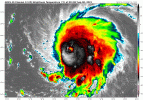
EWRC? Not nearly the look this morning it had yesterday.