- Thread starter
- Moderator
- #161
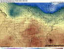
Dorian looks to be heading pretty much due west right now. On track to pass south of most offshore tropical model guidance points.
Follow along with the video below to see how to install our site as a web app on your home screen.
Note: This feature may not be available in some browsers.
The current forecasting is them “thinking” the high pressure system to the north will weaken from what i am seeing. Like you said too much uncertainty now.It looks like it has a heading around 290-295 and at 26N 73W on point with the 06z guidance and euros 12z from yesterday. Big shift in the HWRF today, and further east among the globals. I believe it was Hurricane Maria? Or one around that time frame where the system seemed to be teasing the forecast track and did everything but cooperate for days. That's to say there's always a lot of uncertainty even if you have model agreement across the board. Nobody on the coast should let their guard down and I'm certain they won't. The unpredictability I think has been communicated to the public rather well by the NHC & media.
There's so much uncertainty on Dorian's eventual track that it's definitely a time to focus on the overall cone the NHC uses versus being married to the actual forecast track. A somewhat minor 15-25 mile shift in Dorian's track over the next few days, or subtle changes in the ridge or trough, could have out-sized impacts on Dorian's eventual path. I feel zero confidence saying Florida will experience a landfall, and I also feel no confidence to say that Dorian is going out to sea.
The NHC is splitting the difference right now, and I honestly think that's largely because that's the safest and most logical solution at this point. To me, there's no clear indicators one way or the other, and the NHC are the best in the business. They know that. And they know they've got to have a forecast fit for public consumption. That's why they almost always just gradually adjust their track when models change (even with significant model changes).
We could see a continued trend to the NE which pushes Dorian OTS, or we might see the models start to trend back westward. There's very little skill in determining the path 4-5 days out when you have such a complex setup and (at times) divergent model solutions. I know one thing for certain...if anyone tells you they've got it all figured out...they absolutely do not.
The only thing that I see this morning that could change this is that the ridge to the north and west appears to be extended a little further east than before, if that trend continues, the weakness will not be as prominent, and if it extends further, the "escape route" could be missed by the storms slower movement. I would feel better is I saw a true trough building in...that is not the case..it is truly the ridge weakening...and weakening north of the storm..a big difference.I understand what your saying, but from Florida’s standpoint do really think most of models that will come into consensus today farther east based on the main Euro and GFS and then all of a sudden 24 hours later change and then shift back west? I just don’t see envision that happening as a possibility. It took at least a few days for the Euro to change it’s mind before it decided to go with the offshore solution and given that the storm will be closer to land later today than it was a couple days ago it seems less likely things will change. I see this as an out to sea storm with a slight chance of a minimal hurricane landfall in South Carolina or North Carolina area.
I understand what your saying, but from Florida’s standpoint do really think most of models that will come into consensus today farther east based on the main Euro and GFS and then all of a sudden 24 hours later change and then shift back west? I just don’t see envision that happening as a possibility. It took at least a few days for the Euro to change it’s mind before it decided to go with the offshore solution and given that the storm will be closer to land later today than it was a couple days ago it seems less likely things will change. I see this as an out to sea storm with a slight chance of a minimal hurricane landfall in South Carolina or North Carolina area.

Per the gfs, the turn north isnt expected until tomorrow night.Dorian still moving west.