CoreyandFrosty
Member
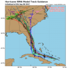
Wow this hurricane really is huge in size. If the track is just right, I could see Atlanta getting hurricane force winds.
Follow along with the video below to see how to install our site as a web app on your home screen.
Note: This feature may not be available in some browsers.
Southern florida doesn't do much to weaken hurricanes due the the Everglades.If this hurricane rides up Fl, it will be very weak by the time it reaches Atlanta right? No way category 1 winds can reach ATL if this is over land the whole time.
Supposedly the trough that is bringing us ( in N AL) the nice weather today will kick it out to the east. My concern is that the trough will move out more quickly than forecast or that the storm will slow some and let it ride up the backside of the trough. I haven't seen that modeled anywhere, but it is something that I have been considering for the past few days. Also, Mark Sudduth at Hurricane Track.com is a really good resource for all hurricanes. His HurricaneImpact app is something I look at regularly. I have no connection to him at all, just appreciate his work.What is to keep this storm from pulling a westward move like Katrina? I am new here, and just really enjoy reading all of your ideas!
That is seriously my dream. I wanna do that!Just watching a woman in a wind tunnel on CNN who is regretting she volunteered for this every second.....

Well, *that's* not exactly hitting the Georgia and South Carolina coast... That brings it to my back yard!While we wait for the 00z runs, the official NHC track has shifted west.