• Welcome to TalkWeather!
    We see you lurking around TalkWeather! Take the extra step and join us today to view attachments, see less ads and maybe even join the discussion.
    CLICK TO JOIN TALKWEATHER

Archive Former Major Hurricane Irma

JayF

Technical Administrator
Staff member
Administrator
Moderator
Technical Admin
Sustaining Member
Messages
1,628
Reaction score
899
Location
Hartselle, al
HAM Callsign
KB4JCS
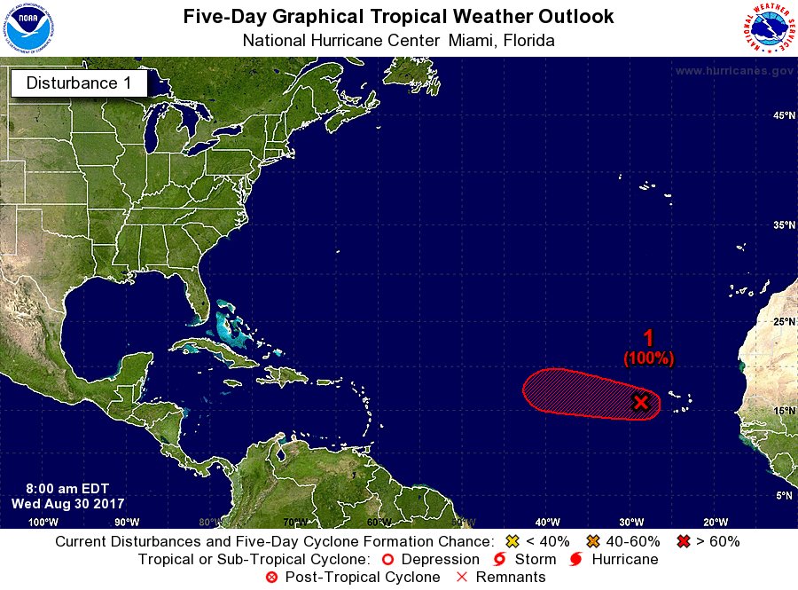
MIAMI, Florida - NOAA's National Hurricane Center issued a Tropical Weather Outlook at 2 p.m. Eastern Daylight Time on Tuesday, August 29, 2017, due to the presence of an area of low pressure that could become a Tropical Storm Jose later this week.


The area of low pressure (red X above), dubbed Invest 93L, is located near the Cabo Verde Islands.

Showers and thunderstorms associated with Invest 93L have become better organized since yesterday and will likely form into Tropical Depression 11 by Thursday over the eastern Atlantic.

NHC forecasters say that Invest 93L will move westward at 15 to 20 mph over the tropical Atlantic during the next several days.

Invest 93L has a 90% chance of becoming a tropical cyclone within the next five days.

http://news.brevardtimes.com/2017/08/2017-invest-93l-projected-path.html
 

WesL

"Bill, I'm talkin' imminent rueage"
Administrator
Moderator
Sustaining Member
Messages
3,423
Reaction score
2,777
Location
Fayetteville, AR
Special Affiliations
  1. SKYWARN® Volunteer


A little far out to be making that call.... IMO
 
  • Thread starter
  • Admin
  • #3

JayF

Technical Administrator
Staff member
Administrator
Moderator
Technical Admin
Sustaining Member
Messages
1,628
Reaction score
899
Location
Hartselle, al
HAM Callsign
KB4JCS
Yeah no doubt. I figure 92L has a better chance of being Irma than 93L.
 

akt1985

Member
Messages
1,073
Reaction score
613
Location
Madison, Alabama
If 93L develops, the GFS has a track similar to the Labor Day Hurricane of 1935. The EURO has the storm going out to sea after hitting the Leeward Islands.
 

Mike S

Administrator
Staff member
Administrator
Moderator
PerryW Project Supporter
Messages
2,078
Reaction score
1,307
Location
Meridianville, Al
Special Affiliations
  1. SKYWARN® Volunteer
Advisories likely to be initiated at 11am EDT

DIeaOZVVwAAYS5Y.jpg:large
 
  • Thread starter
  • Admin
  • #7

JayF

Technical Administrator
Staff member
Administrator
Moderator
Technical Admin
Sustaining Member
Messages
1,628
Reaction score
899
Location
Hartselle, al
HAM Callsign
KB4JCS
Looks like this will be Irma after all.
 
  • Thread starter
  • Admin
  • #8

JayF

Technical Administrator
Staff member
Administrator
Moderator
Technical Admin
Sustaining Member
Messages
1,628
Reaction score
899
Location
Hartselle, al
HAM Callsign
KB4JCS
Current Model Guidance for Path of Irma


storm_93.gif
 
  • Thread starter
  • Admin
  • #9

JayF

Technical Administrator
Staff member
Administrator
Moderator
Technical Admin
Sustaining Member
Messages
1,628
Reaction score
899
Location
Hartselle, al
HAM Callsign
KB4JCS
Intensity Forecast for TS Irma

11L_intensity_latest.png
 
  • Like
Reactions: KoD

Snowfan

Member
Messages
8
Reaction score
0
Location
Not telling
ZCZC MIATCDAT1 ALL
TTAA00 KNHC DDHHMM

Tropical Storm Irma Discussion Number 3
NWS National Hurricane Center Miami FL AL112017
1100 PM AST Wed Aug 30 2017

Irma continues to become better organized, with the development of
a small CDO feature and increased banding near the center. An
earlier high-resolution Windsat microwave overpass showed that Irma
has a tight inner core and a low-level eye-like feature was
present. A Dvorak classification of T3.5 from TAFB is the basis
for the initial intensity of 55 kt. Irma is expected to steadily
strengthen during the next couple of days while it moves through a
low-shear and moist environment, and remains over warm sea
surface temperatures. After that time, slightly cooler SSTs and
lower mid-level moisture may temper the intensification process.
However, the statistical aids, HWRF, and most of the consensus
models make Irma a major hurricane by the end of the forecast
period. The NHC forecast is fairly similar to the previous advisory
through 48 hours, but is above the earlier forecast thereafter. The
new official intensity forecast could still be a little conservative
as it remains a little below the SHIPS/LGEM guidance and the ICON
consensus at days 4 and 5.

Irma is moving westward at about 10 kt to the south of deep-layer
ridge over the eastern Atlantic. The track forecast reasoning is
about the same as the previous advisory, with Irma expected to turn
west-northwestward on Thursday, then continue on that heading
for a couple of days. The high pressure ridge over the central
Atlantic is forecast to strengthen later this week, which is
expected to result in Irma turning west-southwestward by the
weekend. There is still some spread among the track models, so the
NHC forecast lies near a blend of the typically reliable GFS and
ECMWF, and the HFIP corrected consensus.


FORECAST POSITIONS AND MAX WINDS

INIT 31/0300Z 16.4N 32.2W 55 KT 65 MPH
12H 31/1200Z 16.8N 33.6W 65 KT 75 MPH
24H 01/0000Z 17.3N 35.5W 75 KT 85 MPH
36H 01/1200Z 17.7N 37.3W 85 KT 100 MPH
48H 02/0000Z 18.0N 39.5W 90 KT 105 MPH
72H 03/0000Z 17.6N 44.3W 95 KT 110 MPH
96H 04/0000Z 16.8N 49.0W 100 KT 115 MPH
120H 05/0000Z 16.2N 53.5W 105 KT 120 MPH

$$
Forecaster Brown

NNNN
 

JayF

Technical Administrator
Staff member
Administrator
Moderator
Technical Admin
Sustaining Member
Messages
1,628
Reaction score
899
Location
Hartselle, al
HAM Callsign
KB4JCS
GFS has Irma curving north and staying out of the Caribbean. The Euro has it coming closer to the Caribbean and a few have it going further south.
 

South AL Wx

Member
Meteorologist
Messages
366
Reaction score
492
Location
Wetumpka, AL
Special Affiliations
  1. SKYWARN® Volunteer
Well, that was quick! Irma is already a category 2 hurricane:

SUMMARY OF 1100 AM AST...1500 UTC...INFORMATION
-----------------------------------------------
LOCATION...16.9N 33.8W
ABOUT 650 MI...1050 KM W OF THE CABO VERDE ISLANDS
ABOUT 1845 MI...2975 KM E OF THE LEEWARD ISLANDS
MAXIMUM SUSTAINED WINDS...100 MPH...155 KM/H
PRESENT MOVEMENT...WNW OR 290 DEGREES AT 10 MPH...17 KM/H
MINIMUM CENTRAL PRESSURE...979 MB...28.91 INCHES


Tyler Penland

Mountain Snow Miser
Emeritus Moderator
Messages
254
Reaction score
154
Location
Blowing Rock, NC; Elevation 3,575ft
Well, that was quick! Irma is already a category 2 hurricane:

SUMMARY OF 1100 AM AST...1500 UTC...INFORMATION
-----------------------------------------------
LOCATION...16.9N 33.8W
ABOUT 650 MI...1050 KM W OF THE CABO VERDE ISLANDS
ABOUT 1845 MI...2975 KM E OF THE LEEWARD ISLANDS
MAXIMUM SUSTAINED WINDS...100 MPH...155 KM/H
PRESENT MOVEMENT...WNW OR 290 DEGREES AT 10 MPH...17 KM/H
MINIMUM CENTRAL PRESSURE...979 MB...28.91 INCHES

Well she's taking off. I really think the rapid strengthening is gonna pull her further north than the Euro is showing.
vis0-lalo.gif
 

JayF

Technical Administrator
Staff member
Administrator
Moderator
Technical Admin
Sustaining Member
Messages
1,628
Reaction score
899
Location
Hartselle, al
HAM Callsign
KB4JCS
Irma will is forecasted by NHC to be a Major Hurricane sometime today.

IRMA_145426_5day_cone_no_line_and_wind.png
 

South AL Wx

Member
Meteorologist
Messages
366
Reaction score
492
Location
Wetumpka, AL
Special Affiliations
  1. SKYWARN® Volunteer
Why is the NHC track south of all of the Models?

Here's what NHC says in their discussion:

Irma has moved somewhat south of and slower than all of the model
guidance since yesterday.

Guidance continues to trend southward, following the trend of
the ECMWF model starting yesterday. Given the strength of the ridge
and depth of the tropical cyclone, there are no obvious reasons to
discount the anomalous west-southwestward motion seen in most of the
guidance. Little change is made to the track forecast in short
range, but the track is shifted southward and westward at long
range, though not as far southwest as the overnight ECMWF and ECMWF
ensemble models.
 

WesL

"Bill, I'm talkin' imminent rueage"
Administrator
Moderator
Sustaining Member
Messages
3,423
Reaction score
2,777
Location
Fayetteville, AR
Special Affiliations
  1. SKYWARN® Volunteer
Irma has moved somewhat south of and slower than all of the model
guidance since yesterday.
Almost never a good sign this far out. Thankful we have the humans at NHC who can forecast this thing especially for those island nations. Hang on folks. I think it is going to be Irma's Wild Ride.
 

Blountwolf

Member
PerryW Project Supporter
Sustaining Member
Messages
777
Reaction score
1,301
Location
Blount Springs
Well, that escalated quickly.
 
Logo 468x120
Back
Top