- Admin
- #41
- Messages
- 2,433
- Reaction score
- 2,273
- Location
- Meridianville, Al
- Special Affiliations
- SKYWARN® Volunteer
Follow along with the video below to see how to install our site as a web app on your home screen.
Note: This feature may not be available in some browsers.
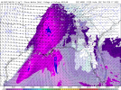
New SPC D2 upgraded to ENH for parts of the outlook area. Upgrade is for tornadoes (some strong) and damaging winds.
View attachment 12251

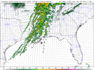
...Arklatex region eastward across the Mid South and central Gulf
Coast region...
Widespread showers and embedded thunderstorms will be ongoing at the
start of the period from southeastern Kansas southward to eastern
Oklahoma and Arkansas and into northeastern Texas at the start of
the period, near and ahead of the advancing surface low/cold front.
Meanwhile, largely elevated, warm advection-induced convection will
extend northeastward across the Mid Mississippi and Ohio Valleys and
vicinity. While meager CAPE is expected early in the period, strong
flow aloft suggests that locally damaging wind gusts will be a
possibility from the Arklatex region eastward toward the Mississippi
Delta area through mid afternoon.
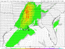
With time, deepening of the low and associated strengthening of
low-level southerlies will allow persistent northward theta-e
advection to combine with modest/local diurnal warming, eventually
yielding evolution of mixed-layer CAPE up to about 500 J/kg. Across
Kentucky and areas north, a cool boundary layer should persist,
resulting in slightly stable conditions beneath evolving, modest
instability. However, this thermodynamic concern is partially
offset by stronger ascent aloft spreading across this region --
along with the deepening low expected to track along roughly the
Ohio River through late afternoon and into the evening. With this
ascent likely to maintain partially forced convection, and given
exceptionally strong/veering flow with height across this region,
potential for locally damaging winds and a couple of tornadoes
remains a possibility.
Farther south, greater low-level theta-e advection suggests that the
boundary layer will become at least neutral, and therefore greater
certainty of surface- or near-surface-based storms exists -- both
near the advancing cold front, and also with associated warm
advection-driven bands of convection in the free warm sector. As
noted above, very strong shear -- with south-southwesterly 850 mb
winds in excess of 50 to 60 kt increasing to west-southwesterly at
70 to 90 kt at mid levels -- is suggestive of supercells, and
attendant risk for damaging winds and several -- and possibly
locally strong/damaging -- tornadoes. As such, an upgrade to
enhanced risk is being introduced, centered across the Tennessee
Valley area from late afternoon through the evening hours.


Franklin County Schools (AL) | Closing Early at 12:30PM Thursday | Public School |
Lauderdale County Schools | Virtual Learning Thursday | Public School |
Muscle Shoals City Schools | Early Dismissal at 1:00PM on 2022-02-17 | Public School |
Russellville City Schools | Early Dismissal at 1:00PM Thursday | Public School |
Tuscumbia City Schools | Early Dismissal at 1:00PM on 2022-02-17 | Public School |

Florence City Schools dismissing at 11:30If we start seeing more of these we may should start a separate thread, but some north Alabama school systems are closing early on Thursday, and one will be virtual all day.
Franklin County Schools (AL)Closing Early at 12:30PM Thursday Public School
Lauderdale County SchoolsVirtual Learning Thursday Public School
Muscle Shoals City SchoolsEarly Dismissal at 1:00PM on 2022-02-17 Public School
Russellville City SchoolsEarly Dismissal at 1:00PM Thursday Public School
Tuscumbia City SchoolsEarly Dismissal at 1:00PM on 2022-02-17 Public School
Looks like line with embedded super cells. Usually can drop a few tornadoes but they aren’t long lived, usually one storm is the storm of the day with this type of an event
Showers and thunderstorms likely, then showers and possibly a thunderstorm after 11am. Some of the storms could be severe. High near 73. Windy, with a south wind 15 to 20 mph increasing to 25 to 30 mph in the afternoon. Winds could gust as high as 50 mph. Chance of precipitation is 100%. New rainfall amounts between 1 and 2 inches possible.