JasonL
Member
Please No!Trends will have to be monitored, but I'm really considering that Helene could pull a track similar to Opal.
Follow along with the video below to see how to install our site as a web app on your home screen.
Note: This feature may not be available in some browsers.
Please No!Trends will have to be monitored, but I'm really considering that Helene could pull a track similar to Opal.
Excessive Rainfall Discussion
NWS Weather Prediction Center College Park MD
410 PM EDT Tue Sep 24 2024
Day 2
Valid 12Z Wed Sep 25 2024 - 12Z Thu Sep 26 2024
...THERE IS A MODERATE RISK OF EXCESSIVE RAINFALL OVER PORTIONS OF
NORTHERN GEORGIA THROUGH THE SOUTHERN APPALACHIANS...
...2030Z Update...
...Southern Appalachians...
In coordination with FFC/Peachtree City; GSP/Greer, SC; and
MRX/Morristown, TN forecast offices, a Moderate Risk upgrade was
introduced with this update.
There was unanimous agreement in the 12Z guidance of an eastward
shift in the axis of heaviest rainfall associated with training
storms ahead of an advancing cold front across Tennessee, Alabama,
and Georgia. This will be the making of a predecessor rain event,
or PRE. The PRE will take advantage of increasing deep tropical
moisture streaming north ahead of what is forecast to be Hurricane
Helene, which will be moving northward into the eastern Gulf. The
tropical moisture running into the front from the east will oppose
the westward movement of the front, and frankly the upper level
trough associated therewith as well.
The expected stalling of the front will allow the storms that form
along it to train northward. This pattern alone is favorable for
flash flooding, but once the storms reach northern Georgia, western
Carolinas, and far eastern Tennessee, then they will have the
terrain of the southern Appalachians to contend with. The mountains
will help uplift the moisture and storms, resulting in localized
enhancement of the rain. Lower FFGs in the terrain will mean flash
flooding will be more common there. Further south, the axis of the
PRE's storms will likely be in or very near Atlanta. Urban effects
will also increase the flash flooding potential, as well as the
impacts deriving therefrom. Thus, the Moderate Risk includes all of
the Atlanta Metro as well.
While the PRE, as the name implies, is not expected to be nearly as
impactful for this region as the rainfall from Helene expected
Thursday, the potential for multiple inches of rain so soon before
the arrival of rain associated with a major hurricane will greatly
exacerbate the impacts from flooding from Helene's rains. The
aforementioned eastward shift in the guidance has significantly
worsened the potential threat from Helene's rains, as the areas now
expected to see the worst of the rains from the PRE will also be
within the core rain plume from Helene.
...Florida...
The Slight Risk in the Florida Big Bend Region was left alone as
this area will be in the crosshairs for some of Helene's worst
rains. The rains will be fairly light when they become steady
through the evening, but pick up in intensity through the early
morning hours. Enough rain may fall there before 12Z for localized
flooding impacts, though by far the worst impacts will hold into
the Day 3/Thursday time period.
A Slight Risk area was introduced for the urban centers (Tampa
through Ft. Myers) of Florida's West Coast with this update. Training
convection associated with multiple back-to-back bands of rain on
the outer fringes of Helene's circulation may cause local flash
flooding, especially in the urban areas. Given antecedent wet
conditions and the potential for frictional effects to result in
band development along the coast, the Slight Risk was added with
the somewhat higher confidence of flash flooding there.
Wegman
Excessive Rainfall Discussion
NWS Weather Prediction Center College Park MD
410 PM EDT Tue Sep 24 2024
Day 3
Valid 12Z Thu Sep 26 2024 - 12Z Fri Sep 27 2024
...THERE IS A MODERATE RISK OF EXCESSIVE RAINFALL OVER PORTIONS OF
THE SOUTHEAST...
...2030Z Update...
In coordination with all of the impacted offices, the Moderate Risk
was expanded north to include much of the east facing slopes of the
Southern Appalachians with this update.
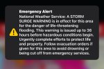
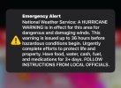
What is forecast to be Major Hurricane Helene is forecast to make
landfall in the Big Bend Region of the Florida Panhandle Thursday
evening. Around and well ahead of the arrival of the center of
circulation, bands of locally very heavy rain will impact all of
the Florida Panhandle and portions of the west coast of the Florida
Peninsula. PWATs with Helene are expected to be nearly off the
charts, as the much larger than normal hurricane draws nearly
unlimited moisture from the much warmer than normal eastern Gulf
and efficiently converts it to heavy rainfall. Areas of the Florida
Peninsula east of the track will contend with storm surge along
the coast, which will impact drainage from the heavy
rain...resulting in excessive rainfall flooding due to poor
drainage. Thus, the Slight continues along the Florida Peninsula,
with the Moderate closer to the track.
Fortunately, Helene is likely to be moving at its fastest forward
speed when it makes landfall in the Big Bend region. This should
somewhat reduce the impact potential of the heavy rain. Thus, for
now, a High Risk along the Gulf Coast is not yet anticipated, but
will certainly continue to be considered with new and changing
guidance.
Further north, the intensifying southeast flow ahead of Helene's
center will advect increasingly deep tropical moisture into Georgia
and the Carolinas. The previous day's PRE will give way to the
primary rainfall shield with Helene, only resulting in increasingly
heavy rainfall into north Georgia and the Carolinas, especially
overnight Thursday night. The Moderate Risk was expanded north to
account for the PRE, Helene's rainfall, and the much more dangerous
nature of the impacts from nighttime flash flooding. Mudslides and
landslides will become increasingly common in the southern
Appalachians as rainfall amounts approaching 12 inches are
expected. Despite recent dry conditions in this area, PWATs
exceeding 3 inches in some areas will support storms easily capable
of overwhelming the soils resulting in a very healthy percentage of
the rainfall converting to runoff.
The area from metro Atlanta, much of north Georgia, the western tip
of South Carolina, and much of the mountains of western North
Carolina are considered in a higher-end Moderate Risk, with
increasing potential of eventually needing a High Risk upgrade for
this area. This is for a few reasons: 1) The PRE shifting east (as
mentioned in the D2 discussion) will prime many of the same
southeast facing slopes much more efficiently than in previous
forecasts. 2) Increasing rainfall totals with PWATs potentially
getting as high as 3 inches in some areas means that much more
efficient warm rain processes. 3) Southeast flow perpendicular to
the southwest to northeast orientation of the southern Appalachians
will maximize the upslope component of the flow, resulting in more
rain. 4) Terrain issues, especially after multiple inches of rain
Wednesday could mean multiple mudslides and landslides which could
cut off whole communities from the road network.
For Atlanta, any ERO risk upgrades will be dependent on significant
rain from the PRE on Day 2/Wednesday in the city, as otherwise on
Day 3 the rainfall in Atlanta will likely be similar to surrounding
areas.
The surrounding Slight Risks have generally been expanded in all
directions: In the Florida Peninsula, convergence along the East
Coast with the expansive wind field may result in heavy rain in
urban areas from Orlando to Jacksonville.
Given the eastward shift in the guidance and that much of Helene's
moisture will shift northeast well after landfall, the Slight has
been expanded to include all of South Carolina and central North
Carolina.
Finally, the Slight has also been expanded west to cover nearly all
of Tennessee. Much of the westward shift in the guidance will be
with some of Helene's moisture as it dissipates being absorbed into
a cutoff low over the Mississippi Valley, resulting in a conveyor
belt of moisture and heavy rain over much of Tennessee. That heavy
rain will continue westward with a jet eventually moving into
Missouri and Arkansas by Day 4/Friday. Flash and urban flooding
across the major Tennessee cities from Chattanooga, Nashville,
Knoxville and maybe as far west as Memphis will be possible.
Wegman


Opals tracks looks like it was several hundred miles west of Helene is forecast to be no???Trends will have to be monitored, but I'm really considering that Helene could pull a track similar to Opal.
Correct, though a detour through the Yucatan could influence Helene's track to a significant degree.Opals tracks looks like it was several hundred miles west of Helene is forecast to be no???
Georgia can keep Helene, as far as I'm concerned. I don't think we really want her around.I'm liking the current track very little rain and less wind here in Birmingham. Unless this thing jogs west more
Shhhhh… Helene might hear youGeorgia can keep Helene, as far as I'm concerned. I don't think we really want her around.

I agree! I'll be happy either way as long as the Georgia Alabama game isn't a slop fest hahaGeorgia can keep Helene, as far as I'm concerned. I don't think we really want her around.


 www.wctv.tv