ashtonlemleywx
Member
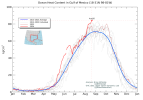
I respect your opinion and explanations. I chase tornadoes not hurricanes, so I'm not a tropical expert. I'm just wondering where do you think the dry air comes from if the SAL has nothing to do with it? If the dusty air from the SAL doesn't make dry air, what is doing it? If you have a better explanation I would love to hear it because I want to understand these things.4 named storms 2 hurricanes and a major along with 40+ ace before mid August is by no stretch of the imagination “below average”.
This isn’t like 2020 with a bunch of slop storms that would’ve never been named 20 years ago. Literally only 4 seasons are ahead of this one in terms of ace as of now.
View attachment 29631
Sal hasn’t been a “huge hindrance” at all otherwise this wouldn’t be the case, and this is despite it being above average this year as well, which comes back to my point that Sal only affects the ability of convection to pop up.
It has no bearing on already established tropical waves, you’re getting Sal confused with dry air, which are NOT the same thing.
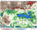
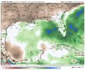
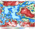
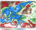
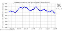
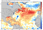
Seems like the western side of the MDR is getting dominated by dry air and dust at the moment. We have the warmest Atlantic on record, favorable wind shear, and the MDR is typically more active at this point. I know a lot can change between now and then....but I'm going to die on the hill saying that SAL has a lot to do with it. I think without the SAL... the Atlantic would've exploded into something extraordinary by now given the favorable conditions.
Maybe I need to be re-educated on the whole subject, but I've always heard that the SAL typically dies down and starts producing less dust/dry air around 2nd-3rd week of August.... is it just a coincidence that is typically the time the "Tropical light switch" flips on and things ramp up?
Also I don't know if I would use ACE as an indicator of an above average season, especially in August. I would maybe wait towards end of season to start throwing ACE around. Go subtract the 1 anomalous July Cat 5 from the equation and you have an average/below average ACE.
Last edited: