
- Moderator
- #281
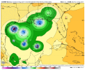
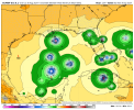
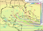
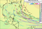
The chances for a nasty tropical situation about to unfold seems pretty high.
Follow along with the video below to see how to install our site as a web app on your home screen.
Note: This feature may not be available in some browsers.
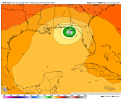
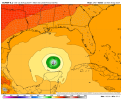
Yep. I would be very worrisome for something getting into the Caribbean and especially Gulf going forward. SST and OHC (Oceanic Heat Content) both remain well above normal in both areas.The chances for a nasty tropical situation about to unfold seems pretty high.
Yep. I would be very worrisome for something getting into the Caribbean and especially Gulf going forward. SST and OHC (Oceanic Heat Content) both remain well above normal in both areas.


This season is about to get very interesting.


.jpg")

Yeah, I'm seeing a lot of the boomerang effect on Twitter, even from proper mets, regarding seasonal potential. One thing I do agree with is that official outlets should probably not go so hard on actual specific numerical forecasts for hurricane seasons, because it just sets us up for failure regarding public communications.And yes I Atmospheric Anti-Climax my totals this season. I went too aggressive but it was solely based on what I've learned over the years. Obviously we still have so much to learn. But I'll be even more foolish if I just sat back and said nothing else will happen the rest of the season.
The sentiment I saw from a few folks was just generally doing an "active, average, underactive" scheme, and also avoiding hyperactivity descriptors.Which brings up a question if we should start doing or looking into probabilistic Hurricane forecasting instead of the whole total numbers. I personally might look into doing that next year. Just food for thought


