Sawmaster
Member
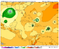
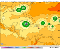
Invest 98l now so more storm details should be coming soon.
Follow along with the video below to see how to install our site as a web app on your home screen.
Note: This feature may not be available in some browsers.
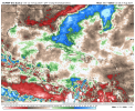
ZCZC MIATWOAT ALL
TTAA00 KNHC DDHHMM
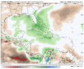
Tropical Weather Outlook
NWS National Hurricane Center Miami FL
800 AM EDT Sat Aug 10 2024
For the North Atlantic...Caribbean Sea and the Gulf of Mexico:
1. Near the Lesser and Greater Antilles (AL98):
Shower and thunderstorm activity has increased since yesterday in
association with a tropical wave located roughly midway between the
Cabo Verde Islands and the Lesser Antilles. Gradual development of
this system is possible during the next couple of days while it
moves westward to west-northwestward across the central tropical
Atlantic. Afterwards, conditions are expected to become more
conducive for development, and a tropical depression is likely to
form by the early to middle part of next week while the system
approaches and then moves near or over the Lesser Antilles. The
system is forecast to continue moving generally west-northwestward
and could approach portions of the Greater Antilles by the middle to
latter part of next week.
* Formation chance through 48 hours...low...30 percent.
* Formation chance through 7 days...high...80 percent.
Forecaster Reinhart
I mean I agree with most of what you are saying....but it has been a huge hindrance this season and I don't think it's overhyped.People over estimate the effects of Sal, as it’s present all season long. Sal is simply a continues plume of dust that creates an elevated mixed layer effect, or cap.
It can be a hindrance to convection trying to initiate but it has no impact on already established tropical waves.
It’s the amount of precipitable water/ mid level relative humidity that matters, and there’s quite a lot of it and will only increase from here.
View attachment 29613
4 named storms 2 hurricanes and a major along with 40+ ace before mid August is by no stretch of the imagination “below average”.I mean I agree with most of what you are saying....but it has been a huge hindrance this season and I don't think it's overhyped.
I know Beryl was record breaking, but other than that this season is below average to this point. We air halfway through August haven't even made it the "E" storm yet.

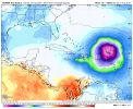
Not really? Seems to be on track per NHC, it already has close to TS force winds and simply needs a well defined center to be classified.PTC 5 seems to be struggling to consolidate longer than expected...perhaps moving too fast for its own good. Didn't we see this with at least one system last year or in 2022?


 www.wjcl.com