• Welcome to TalkWeather!
    We see you lurking around TalkWeather! Take the extra step and join us today to view attachments, see less ads and maybe even join the discussion.
    CLICK TO JOIN TALKWEATHER
  • April 2024 Weather Video of the Month
    Post your nominations now!

2023 Tropical Weather

Messages
539
Reaction score
478
Location
Northern Europe
The big high over Texas is going to shift north east which should make things more favorable for the Gulf.
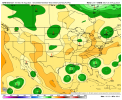
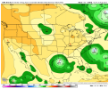
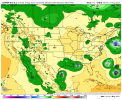
I’m not so sure about that. The EPS, if anything, shows mid-level ridging becoming even more entrenched by D5. Moreover, the pattern depicted is retrogressive. Anything that develops over or near the Gulf during the next five days would likely head due west or even south of due west, toward the U.S.–Mexico border or perhaps far South Texas. On the other hand, a piece of the monsoonal trough that has just left West Africa, currently positioned near 12°N 35°W, is projected to be near the northeastern Caribbean by D5. If such a system were to intensify, it might stall east of the Bahamas and then head west-northwestward, across FL and toward the northwestern Gulf Coast. A stronger system, forming in the MDR, would be more likely to affect the Gulf Coast than a homegrown one, given the strength and orientation of ML ridging. Even so, at this stage either solution seems unlikely to me.
 

Clancy

Member
Messages
3,195
Reaction score
6,016
Location
Macland, Georgia
Checks calendar. August 15th. Atlantic:
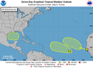
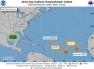
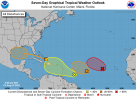
Eastern Atlantic systems are under increasingly watchful eyes at the NHC.
1692202464833.png
ZCZC MIATWOAT ALL
TTAA00 KNHC DDHHMM

Tropical Weather Outlook
NWS National Hurricane Center Miami FL
800 AM EDT Wed Aug 16 2023

For the North Atlantic...Caribbean Sea and the Gulf of Mexico:

1. Central Tropical Atlantic:
Disorganized showers and thunderstorms located over the central
tropical Atlantic are associated with an elongated trough of low
pressure centered about 750 miles west-southwest of the Cabo Verde
Islands. Environmental conditions appear conducive for gradual
development of this system, and a tropical depression could form
during the next several days while moving toward the west or
west-northwest at about 10 mph across the central tropical Atlantic.
* Formation chance through 48 hours...low...30 percent.
* Formation chance through 7 days...medium...50 percent.

2. Eastern Tropical Atlantic:
A tropical wave moving off the west coast of Africa is producing a
large area of disorganized showers and thunderstorms. This system
is forecast to move toward the west-northwest at about 15 mph, with
an area of low pressure expected to form in a day or so near or
just to the west of the Cabo Verde Islands. Further development of
the low is possible, and a tropical depression could form over the
weekend before environmental conditions become unfavorable early
next week.
* Formation chance through 48 hours...low...20 percent.
* Formation chance through 7 days...medium...40 percent.

3. Western Gulf of Mexico:
A broad area of low pressure could form in the central or western
Gulf of Mexico by the beginning of next week. Some slow development
of this system is possible thereafter as it moves westward and
approaches the western Gulf of Mexico coastline by the middle of
next week.
* Formation chance through 48 hours...low...near 0 percent.
* Formation chance through 7 days...low...20 percent.

Forecaster Bucci
 
Messages
539
Reaction score
478
Location
Northern Europe
Yet another high-end Category-4+ cyclone, Hilary, is likely developing over the EPAC. Current satellite-derived imagery indicates an exceedingly well-developed outflow-channel in all quadrants but the northwestern, and an eye is rapidly becoming visible. Northwesterly shear is likely the only impediment at the moment, but PWATs, heat content, and SSTA, along with structural organisation, all favour rapid intensification in the short term. The contrast between the active EPAC and a still-struggling Atlantic as we near climatological peak is telling. Moreover, models, particularly the reliable EC and UKMET, continue to temper expectations in regard to the two new INVESTs over the east-central MDR, reducing projected short-to-medium-term intensities, while remaining relatively bearish in regard to the potential GoM system. Despite this, the main negative factor in the Atlantic to date, as mentioned previously, has not been Niño-induced shear, but rather dry, stable air—the latter likely related, in part, to the warm subtropical North Atlantic.
 

JBishopwx

Member
Sustaining Member
Messages
944
Reaction score
2,152
Location
Ackerman, MS
Special Affiliations
  1. SKYWARN® Volunteer
Atlantic side of things this morning.
 

Attachments

  • 367703309_664555565613745_3545316781895355128_n.jpg
    367703309_664555565613745_3545316781895355128_n.jpg
    139.1 KB · Views: 0
Messages
539
Reaction score
478
Location
Northern Europe
Aside from stable air, the global models show Niño-induced, TUTT-related shear over most of the MDR within five days. For this reason the latest 18Z/06Z EPS suites have become much less bullish in regard to the two waves in the east-central MDR. Now that +ENSO-linked feedback is beginning to play a role, significant impacts on the CONUS may be hard to come by for the rest of the season, fortunately (unless one counts potential crossovers from the EPAC, like Hilary). If this year were similar to 1965, major impacts on the CONUS would be more likely: but Hurricane Betsy, notwithstanding +ENSO, did not also have to contend with warm SSTA in the subtropical Atlantic. So this +ENSO is going to be more unfavourable in the Atlantic than a typical Niño, owing to the fact that the warmest SSTA are in the subtropics rather than the MDR, which was not the case in 1965. No one should “cancel” the season, of course, but I’ll be honest: the chances of “cancelling” are better than average this year, even compared to those of a “typical” +ENSO-type setup.
 

Jacob

Member
Messages
1,299
Reaction score
850
Location
Roy, UT
It could certainly get interesting around here...
WeatherStory3.png

Going to be a good bit of flooding from Hillary for sure. I was hoping for a little more easterly track to get more of the moisture up my way, but that’s looking less and less likely.
 

Taylor Campbell

Moderator
Moderator
PerryW Project Supporter
Messages
2,147
Reaction score
2,272
Location
Wedowee, AL
Special Affiliations
  1. SKYWARN® Volunteer
I see that the NHC labeled the tropical feature that I’ve been following since it left Africa last Friday.
 
Last edited:
Messages
539
Reaction score
478
Location
Northern Europe
Models, especially the EPS, continue to delay the development and reduce the intensities of the four systems in the Atlantic basin. At the current rate I doubt that any of the aforementioned systems will develop, or in the best case move beyond depression-status. There is simply too much stability, and as time goes by, El Niño only enhances shear toward September. I am cautiously optimistic that the U.S. will catch a respite from Atlantic activity this year. Hilary, as mentioned, is potentially another story, but personally I think that the -PMM and dry air will take a toll prior to landfall, thereby reducing the potential precipitation somewhat. I doubt that the worst-case scenarios will come close to verifying.
 

Taylor Campbell

Moderator
Moderator
PerryW Project Supporter
Messages
2,147
Reaction score
2,272
Location
Wedowee, AL
Special Affiliations
  1. SKYWARN® Volunteer
The lead disturbance marked at 10%/30% by the NHC approaching the Lesser Antilles appears to be the primary concern for impacts to the islands in a few days and potentially the US in the long term. The operational EURO over the course of several runs recently continues to track this feature into the Caribbean with genesis into a deeper surface low. The EURO has done a good job with this system way back around the 8th of August.
 

JPWX

Member
Messages
1,609
Reaction score
4,390
Location
Smithville MS
Here's the latest Ensemble guidance
 

Attachments

  • gfs-ensemble-all-avg-conus-mslp_ens_min-3288800 (1).png
    gfs-ensemble-all-avg-conus-mslp_ens_min-3288800 (1).png
    117.9 KB · Views: 0
  • gfs-ensemble-all-avg-conus-mslp_ens_min-3288800.png
    gfs-ensemble-all-avg-conus-mslp_ens_min-3288800.png
    112.8 KB · Views: 0
  • cmc-ensemble-all-avg-conus-mslp_ens_min-2975600.png
    cmc-ensemble-all-avg-conus-mslp_ens_min-2975600.png
    109.2 KB · Views: 0
  • ecmwf-ensemble-avg-conus-mslp_ens_min-3440000.png
    ecmwf-ensemble-avg-conus-mslp_ens_min-3440000.png
    146.7 KB · Views: 0
Logo 468x120
Top