
Navigation
Install the app
How to install the app on iOS
Follow along with the video below to see how to install our site as a web app on your home screen.
Note: This feature may not be available in some browsers.
More options
-
Welcome to TalkWeather! We see you lurking around TalkWeather! Take the extra step and join us today to view attachments, see less ads and maybe even join the discussion. CLICK TO JOIN TALKWEATHER
You are using an out of date browser. It may not display this or other websites correctly.
You should upgrade or use an alternative browser.
You should upgrade or use an alternative browser.
2023 Tropical Weather
- Thread starter JBishopwx
- Start date

TH2002
Member
- Messages
- 4,973
- Reaction score
- 11,113
- Location
- California, United States
- Special Affiliations
- SKYWARN® Volunteer
Just saw a brush fire today, meanwhile I'm also in a Tropical Storm Watch. Hoo boy...
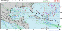
Hilary Local Watch/Warning Statement/Advisory Number 9
National Weather Service San Diego CA EP092023
829 AM PDT Fri Aug 18 2023
CAZ048-182330-
/O.NEW.KSGX.TR.A.2009.230818T1529Z-000000T0000Z/
San Bernardino and Riverside County Valleys-The Inland Empire-
829 AM PDT Fri Aug 18 2023
...TROPICAL STORM WATCH IN EFFECT...
A Tropical Storm Watch means tropical storm-force winds are possible
somewhere within this area within the next 48 hours
* LOCATIONS AFFECTED
- Riverside
- San Bernardino
- Ontario
- Rancho Cucamonga
- Temecula
* WIND
- LATEST LOCAL FORECAST: Equivalent Tropical Storm force wind
- Peak Wind Forecast: 35-45 mph with gusts to 60 mph
- Window for Tropical Storm force winds: Sunday afternoon
until early Monday morning
- THREAT TO LIFE AND PROPERTY THAT INCLUDES TYPICAL FORECAST
UNCERTAINTY IN TRACK, SIZE AND INTENSITY: Potential for wind 39
to 57 mph
- PLAN: Plan for hazardous wind of equivalent tropical storm
force.
- PREPARE: Efforts to protect property should now be
underway. Prepare for limited wind damage.
- ACT: Act now to complete preparations before the wind
becomes hazardous.
- POTENTIAL IMPACTS: Limited
- Damage to porches, awnings, carports, sheds, and unanchored
mobile homes. Unsecured lightweight objects blown about.
- Many large tree limbs broken off. A few trees snapped or
uprooted, but with greater numbers in places where trees
are shallow rooted, especially in coastal and valley
locations that don`t typically experience strong winds.
Some fences and roadway signs blown over.
- A few roads impassable from debris, particularly within
urban or heavily wooded places. Hazardous driving
conditions on bridges and other elevated roadways.
- Scattered power and communications outages.
* FLOODING RAIN
- LATEST LOCAL FORECAST: Flood Watch is in effect
- Peak Rainfall Amounts: 2-4 inches, with locally higher
amounts
- THREAT TO LIFE AND PROPERTY THAT INCLUDES TYPICAL FORECAST
UNCERTAINTY IN TRACK, SIZE AND INTENSITY: Potential for major
flooding rain
- PLAN: Emergency plans should include the potential for
major flooding from heavy rain. Evacuations and rescues are
likely.
- PREPARE: Strongly consider protective actions, especially
if you are in an area vulnerable to flooding.
- ACT: Heed any flood watches and warnings. Failure to take
action will likely result in serious injury or loss of life.
- POTENTIAL IMPACTS: Extensive
- Major rainfall flooding may prompt many evacuations and
rescues.
- Rivers and tributaries may rapidly overflow their banks in
multiple places. Small streams, creeks, canals, arroyos,
and ditches may become dangerous rivers. In mountain areas,
destructive runoff may run quickly down valleys while
increasing susceptibility to rockslides and mudslides.
Flood control systems and barriers may become stressed.
- Flood waters can enter many structures within multiple
communities, some structures becoming uninhabitable or
washed away. Many places where flood waters may cover
escape routes. Streets and parking lots become rivers of
moving water with underpasses submerged. Driving conditions
become dangerous. Many road and bridge closures with some
weakened or washed out.
* TORNADO
- LATEST LOCAL FORECAST:
- Situation is somewhat favorable for tornadoes
- THREAT TO LIFE AND PROPERTY THAT INCLUDES TYPICAL FORECAST
UNCERTAINTY IN TRACK, SIZE AND INTENSITY: Potential for a few
tornadoes
- PLAN: Emergency plans should include the potential for a
few tornadoes.
- PREPARE: If your shelter is particularly vulnerable to
tornadoes, prepare to relocate to safe shelter before
hazardous weather arrives.
- ACT: If a tornado warning is issued, be ready to shelter
quickly.
- POTENTIAL IMPACTS: Limited
- The occurrence of isolated tornadoes can hinder the
execution of emergency plans during tropical events.
- A few places may experience tornado damage, along with
power and communications disruptions.
- Locations could realize roofs peeled off buildings,
chimneys toppled, mobile homes pushed off foundations or
overturned, large tree tops and branches snapped off,
shallow-rooted trees knocked over, moving vehicles blown
off roads, and boats pulled from moorings.
* FOR MORE INFORMATION:
- rivcoready.org
$$
Crossing my fingers for no earthquakes for y'all.Just saw a brush fire today, meanwhile I'm also in a Tropical Storm Watch. Hoo boy...
TH2002
Member
- Messages
- 4,973
- Reaction score
- 11,113
- Location
- California, United States
- Special Affiliations
- SKYWARN® Volunteer
Many thanks! Considering how stressful this season has been (personal and family drama unrelated to the weather) and how close I live to the SAF, I can do without another double-whammy for a while!Crossing my fingers for no earthquakes for y'all.
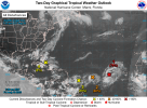
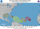
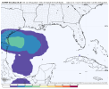
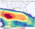
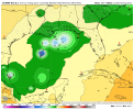
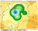
Meanwhile the 18z GFS Ensemble has additional storm or storms entering the Gulf late month. The Canadian and Euro have shown the same thing as well.
Attachments

TH2002
Member
- Messages
- 4,973
- Reaction score
- 11,113
- Location
- California, United States
- Special Affiliations
- SKYWARN® Volunteer
Hilary Local Watch/Warning Statement/Advisory Number 13
National Weather Service San Diego CA EP092023
806 AM PDT Sat Aug 19 2023
CAZ048-192315-
/O.CON.KSGX.TR.W.2009.000000T0000Z-000000T0000Z/
San Bernardino and Riverside County Valleys-The Inland Empire-
806 AM PDT Sat Aug 19 2023
...TROPICAL STORM WARNING REMAINS IN EFFECT...
* LOCATIONS AFFECTED
- Riverside
- San Bernardino
- Ontario
- Rancho Cucamonga
- Temecula
* WIND
- LATEST LOCAL FORECAST: Equivalent Tropical Storm force wind
- Peak Wind Forecast: 35-45 mph with gusts to 60 mph
- Window for Tropical Storm force winds: Sunday morning until
Monday morning
- THREAT TO LIFE AND PROPERTY THAT INCLUDES TYPICAL FORECAST
UNCERTAINTY IN TRACK, SIZE AND INTENSITY: Potential for wind 39
to 57 mph
- The wind threat has remained nearly steady from the
previous assessment.
- PLAN: Plan for hazardous wind of equivalent tropical storm
force.
- PREPARE: Remaining efforts to protect property should be
completed as soon as possible. Prepare for limited wind
damage.
- ACT: Move to safe shelter before the wind becomes hazardous.
- POTENTIAL IMPACTS: Limited
- Damage to porches, awnings, carports, sheds, and unanchored
mobile homes. Unsecured lightweight objects blown about.
- Many large tree limbs broken off. A few trees snapped or
uprooted, but with greater numbers in places where trees
are shallow rooted, especially in coastal and valley
locations that don`t typically experience strong winds.
Some fences and roadway signs blown over.
- A few roads impassable from debris, particularly within
urban or heavily wooded places. Hazardous driving
conditions on bridges and other elevated roadways.
- Scattered power and communications outages.
* FLOODING RAIN
- LATEST LOCAL FORECAST: Flood Watch is in effect
- Peak Rainfall Amounts: Additional 2-4 inches, with locally
higher amounts
- THREAT TO LIFE AND PROPERTY THAT INCLUDES TYPICAL FORECAST
UNCERTAINTY IN TRACK, SIZE AND INTENSITY: Potential for extreme
flooding rain
- The flooding rain threat has remained nearly steady from
the previous assessment.
- PLAN: Emergency plans should include the potential for
extreme flooding from heavy rain. Evacuations and rescues
are likely.
- PREPARE: Urgently consider protective actions from extreme
and widespread rainfall flooding.
- ACT: Heed any flood watches and warnings. Failure to take
action will likely result in serious injury or loss of life.
- POTENTIAL IMPACTS: Devastating to Catastrophic
- Extreme rainfall flooding may prompt numerous evacuations
and rescues.
- Rivers and tributaries may overwhelmingly overflow their
banks in many places with deep moving water. Small streams,
creeks, canals, arroyos, and ditches may become raging
rivers. In mountain areas, deadly runoff may rage down
valleys while increasing susceptibility to rockslides and
mudslides. Flood control systems and barriers may become
stressed.
- Flood waters can enter numerous structures within multiple
communities, some structures becoming uninhabitable or
washed away. Numerous places where flood waters may cover
escape routes. Streets and parking lots become rivers of
raging water with underpasses submerged. Driving conditions
become very dangerous. Numerous road and bridge closures
with some weakened or washed out.
* TORNADO
- LATEST LOCAL FORECAST:
- Situation is unfavorable for tornadoes
- THREAT TO LIFE AND PROPERTY THAT INCLUDES TYPICAL FORECAST
UNCERTAINTY IN TRACK, SIZE AND INTENSITY: Tornadoes not expected
- The tornado threat has remained nearly steady from the
previous assessment.
- PLAN: Tornadoes are not expected. Showers and thunderstorms
with gusty winds may still occur.
- PREPARE: Little to no preparations needed to protect
against tornadoes at this time. Keep informed of the latest
tornado situation.
- ACT: Listen for changes in the forecast.
- POTENTIAL IMPACTS: Little to None
- Little to no potential impacts from tornadoes.
* FOR MORE INFORMATION:
- rivcoready.org
$$
akt1985
Member
Is Jim Cantore in Southern California this weekend?
TH2002
Member
- Messages
- 4,973
- Reaction score
- 11,113
- Location
- California, United States
- Special Affiliations
- SKYWARN® Volunteer
I'd really like to know who thought it was a good idea to go ahead with the Padres games in San Diego and the Post Malone concert at Glen Helen...
Apparently someone who doesn't know there's a hurricane headed towards CaliforniaI'd really like to know who thought it was a good idea to go ahead with the Padres games in San Diego and the Post Malone concert at Glen Helen...
I'd really like to know who thought it was a good idea to go ahead with the Padres games in San Diego and the Post Malone concert at Glen Helen...
Forecast from NWS calls for 1.5-2" in San Diego with peak wind gusts around 35MPH. Why would they cancel the Padres game? They'll obviously delay it if it is raining.
Note: The Padres are playing a doubleheader today instead of playing tomorrow, which makes sense to get the game in with the rain tomorrow.
Last edited:
TH2002
Member
- Messages
- 4,973
- Reaction score
- 11,113
- Location
- California, United States
- Special Affiliations
- SKYWARN® Volunteer
They did reschedule tomorrow's game and push it forward to 5:40 this evening, which I guess is fine considering it isn't supposed to start raining that far west until late tonight at the earliest. Though I am half expecting the concert to get rained out...Forecast from NWS calls for 1.5-2" in San Diego with peak wind gusts around 35MPH. Why would they cancel the Padres game? They'll obviously delay it if it is raining.

Thanksgivingbrown
Member
How come there’s not a dedicated Hilary thread? Millions are affected by this rare weather event
- Thread starter
- #179
- Thread starter
- #180